- Courses
- GS Full Course 1 Year
- GS Full Course 2 Year
- GS Full Course 3 Year
- GS Full Course Till Selection
- CSAT
- 5 LAYERED ARJUNA Mentorship
- Public Administration Optional
- Online Program
- GS Recorded Course
- NCERT Batch
- Polity Module Course
- Geography Module Course
- Economy Module Course
- AMAC Module Course
- Modern India, Post Independence & World History Module Course
- Environment Module Course
- Governance Module Course
- Science & Tech. Module Course
- International Relations and Internal Security Module Course
- Disaster Management Module Course
- Ethics Module Course
- Essay Module Course
- Current Affairs Module Course
- ABOUT US
- OUR TOPPERS
- TEST SERIES
- FREE STUDY MATERIAL
- VIDEOS
- CONTACT US
PLACES IN NEWS 14th MARCH 2025
PLACES IN NEWS 14th MARCH 2025
14-03-2025

Tigray Region
Why in news?
- Ethiopia’s Tigray regional government has appealed for urgent intervention as factional fighters, including militias from the Amhara region and Eritrean forces, seize key towns.
- This escalation follows the fragile 2022 peace deal between the Tigray People's Liberation Front (TPLF) and Ethiopia’s federal government, raising fears of renewed conflict and humanitarian crises
About Tigray Region:
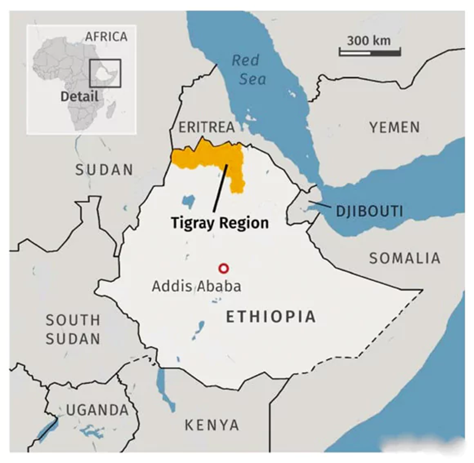
- Location and Geography:
- The Tigray region is Ethiopia’s northernmost state, sharing borders with Eritrea to the north, Amhara to the south, and the Afar region to the east.
- The region covers approximately 102,000 square kilometres, with Mekele as its capital and largest city.
- Tigray is characterised by rugged terrain, plateaus, and river valleys, making it strategically significant in Ethiopia’s history.
- Background of Clashes:
- The Tigray People’s Liberation Front (TPLF) was once the dominant political force in Ethiopia but clashed with the federal government in November 2020, leading to a brutal two-year civil war.
- The war resulted in hundreds of thousands of deaths, massive displacement, and a severe humanitarian crisis, pushing millions to the brink of famine.
- The conflict officially ended with the Pretoria Peace Agreement in November 2022, leading to the establishment of a TPLF-led interim government.
- However, internal divisions within the TPLF emerged in October 2024, when Debretsion Gebremichael expelled interim leader Getachew Reda, escalating tensions in the region.
- Recent Developments:
- On March 11, 2025, a faction of the TPLF seized Adigrat, the second-largest town in Tigray, replacing the government-appointed administrator.
- The next day, the group took control of Adi-Gudem, near Mekele, where armed clashes left several wounded.
- Interim leader Getachew Reda condemned these actions as a “potential coup attempt,” calling for Ethiopia’s federal government and the international community to intervene.
- TPLF’s deputy chairman, Amanuel Assefa, denied violating the Pretoria Agreement, insisting the issue is a local law enforcement matter.
- The situation remains volatile, with fears of a return to full-scale conflict in the war-torn region.
Kanger Valley National Park
Why in news?
- Kanger Valley National Park in Chhattisgarh, known for its biodiversity, limestone caves, and tribal heritage, has been added to UNESCO’s Tentative List of World Heritage Sites.
About Kanger Valley National Park:
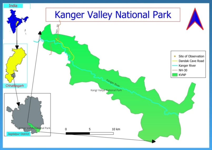
- Location:
- Kanger Valley National Park, also known as Kanger Ghati National Park, is situated in the Bastar region of Chhattisgarh.
- Established in 1982, it spans approximately 200 sq km, extending from Teerathagarh waterfalls in the west to the Kolab River (Odisha border) in the east.
- The Kanger River flows centrally through the park, which is known for its dense forests, limestone caves, and rich biodiversity.
- Flora and Fauna:
- The park boasts mixed moist deciduous forests, with a significant presence of sal, teak, and bamboo. It is one of the last untouched virgin forests in peninsular India.
- Over 550 plant species have been recorded, including medicinal plants, climbers, and ferns, with 43 rare species.
- Kanger Valley is home to a diverse range of wildlife, including tigers, leopards, sambar deer, sloth bears, wild boars, and langurs.
- It also harbours cave-dwelling species like blind fish and bats. The Bastar hill myna, the state bird of Chhattisgarh, is a key attraction.
- The park supports 144 bird species, including eagles, owls, drongos, and peacocks. Reptiles like crocodiles, monitor lizards, and pythons also thrive here.
- Heritage and Significance:
- The park is renowned for its limestone caves, such as Kotumsar, Kailash, and Dandak, which feature magnificent stalactites and stalagmites.
- The Teerathgarh waterfalls, Kanger Dhara, and Bhainsa Darha enhance its scenic beauty.
- Rich in tribal heritage, the park is a centre for ecotourism, wildlife research, and conservation.
Cauvery River
Why in news?
The Cauvery River's water level is dropping due to extreme heat, raising concerns over water scarcity and agricultural impacts in affected regions.
About Cauvery River:
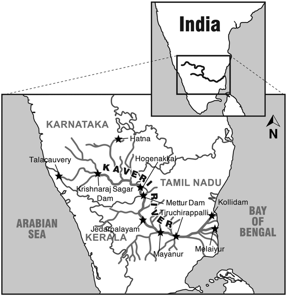
- Origin and Course
- The Cauvery River (also known as Kaveri) is a major river flowing across Southern India. It is the third largest river in the region after the Godavari and Krishna.
- The Cauvery basin covers an area of 81,155 km², spanning Tamil Nadu, Karnataka, Kerala, and Puducherry.
- It originates from Talakaveri in the Brahmagiri Hills of the Western Ghats in Kodagu district, Karnataka, at an altitude of 1,341 m (4,400 ft).
- It flows for about 320 km in Karnataka before entering Tamil Nadu, where it travels another 416 km, finally emptying into the Bay of Bengal near Poompuhar, Mayiladuthurai district. The river covers a total length of 800 km.
- The major tributaries of the Cauvery include Amaravati, Arkavati, Bhavani, Hemavati, Kabini, Lakshmana Tirtha, and Noyyal. These tributaries significantly contribute to the river’s flow and irrigation potential.
- Cultural and Economic Significance
- The Cauvery River is one of the seven sacred rivers of Hinduism. It is revered as the goddess Kaveri and is mentioned in texts like the Mahabharata and Puranas.
- The river is also known as Ponni, meaning the "golden one," due to the rich silt deposits it carries.
- The Cauvery basin has historically supported kingdoms, cities, and agriculture.
- Economically, the river is a lifeline for agriculture, particularly in Tamil Nadu and Karnataka, where it supports the cultivation of rice, sugarcane, and plantation crops.
- It also serves as a source of drinking water and plays a crucial role in hydroelectric power generation.
- Major dams on the river include Krishna Raja Sagara, Mettur, Bhavanisagar, and Kabini, which regulate irrigation and electricity production.
- Reasons Behind Dropping Water Levels
- Weak monsoons: The Southwest monsoon (June-September) and Northeast monsoon (October-December) are the primary sources of rainfall for the river. Deficient rainfall reduces the flow and storage capacity.
- Climate change: Rising temperatures increase evaporation, leading to a shortage of water in reservoirs and reduced groundwater recharge.
- Deforestation and urbanisation: Large-scale land-use changes in the Cauvery basin have impacted natural water retention.
- Over-extraction of water: Excessive irrigation, industrial use, and population pressure lead to rapid depletion.
- Interstate water disputes: Ongoing conflicts between Karnataka and Tamil Nadu over water allocation worsen the management of available resources.
- Impact of Depleting Water Levels
- Agriculture crisis: Lower water availability affects paddy, sugarcane, and other crops, leading to economic distress for farmers.
- Drinking water shortage: Several cities like Bengaluru and Chennai rely on Cauvery water for drinking purposes.
- Hydropower reduction: Lower reservoir levels impact electricity production, leading to power shortages.
- Ecosystem damage: The decrease in flow affects aquatic biodiversity, including species like the humpbacked mahseer and mugger crocodile.
- Disputes intensify: Reduced water flow fuels conflicts between states, affecting cooperative governance.
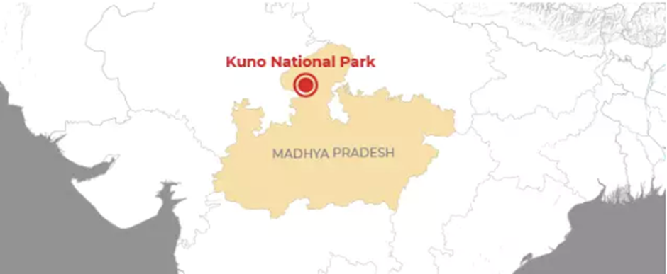
Kuno National Park
Why in news?
- Ancient Stone Age rock art was discovered in Kuno National Park, Madhya Pradesh, featuring human, animal, and geometric figures, offering insights into prehistoric life and early human artistic expressions in Central India.
About Kuno National Park:
-
- Location:
- Location:
- Kuno National Park, located in the Sheopur and Morena districts of Madhya Pradesh, India, spans 748.76 km² and derives its name from the Kuno River.
- Initially established as a wildlife sanctuary in 1981, it was upgraded to a national park in 2018.
- The park has gained prominence for the reintroduction of cheetahs from Africa and its potential to host Asiatic lions.
- Flora and Fauna
- Flora and Fauna
- Kuno National Park is characterized by tropical dry deciduous forests and grasslands, supporting a diverse range of flora.
- The dominant trees include Acacia, Tendu, Palash, and Dhok, while the park’s grasslands provide an ideal habitat for herbivores.
- The park is home to leopards, sloth bears, dholes, wolves, hyenas, jackals, and foxes. It also supports herbivores like sambar deer, chital, nilgai, blackbuck, and chinkara.
- The recent reintroduction of African cheetahs has made Kuno a significant site for conservation.
- Additionally, the Kuno River houses reptiles such as mugger crocodiles and gharials.
|
UPSC CSE PYQs Q1. Consider the following pairs:
How many of the above pairs are correctly matched? (2023)
Answer: Option D
|
|
Also Read |
|
| Public Administration Optional | |
| UPSC Monthly Magazine | Question Answer Practice For UPSC |


PLACES IN NEWS 23rd APRIL 2025

PLACES IN NEWS 22nd APRIL 2025

PLACES IN NEWS 21st APRIL 2025
Karol Bagh Metro Pillar No. 112, Above Domino's, 22B, First Floor, New Delhi - 110060
Copyright © 2024-2026 ENSURE IAS. All rights reserved.