- Courses
- GS Full Course 1 Year
- GS Full Course 2 Year
- GS Full Course 3 Year
- GS Full Course Till Selection
- Answer Alpha: Mains 2025 Mentorship
- MEP (Mains Enrichment Programme) Data, Facts
- Essay Target – 150+ Marks
- Online Program
- GS Recorded Course
- Polity
- Geography
- Economy
- Ancient, Medieval and Art & Culture AMAC
- Modern India, Post Independence & World History
- Environment
- Governance
- Science & Technology
- International Relations and Internal Security
- Disaster Management
- Ethics
- NCERT Current Affairs
- Indian Society and Social Issue
- NCERT- Science and Technology
- NCERT - Geography
- NCERT - Ancient History
- NCERT- World History
- NCERT Modern History
- CSAT
- 5 LAYERED ARJUNA Mentorship
- Public Administration Optional
- ABOUT US
- OUR TOPPERS
- TEST SERIES
- FREE STUDY MATERIAL
- VIDEOS
- CONTACT US
PLACES IN NEWS 23rd APRIL 2025
PLACES IN NEWS 23rd APRIL 2025

Strait of Gibraltar
Why in news?
a. Bengal swimmer Sayoni Das recently became the first Asian woman to successfully swim across the Strait of Gibraltar.
About Strait of Gibraltar:
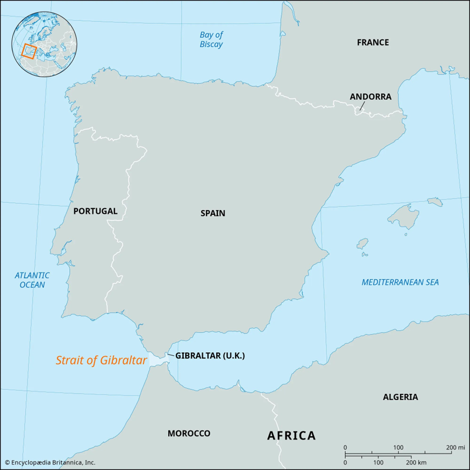
Location and Geography:
- The Strait of Gibraltar is a narrow body of water that separates Europe from Africa, serving as the only natural link between the Atlantic Ocean and the Mediterranean Sea.
- To the north, it is bordered by Spain and the British Overseas Territory of Gibraltar, and to the south, by Morocco and the Spanish enclave of Ceuta.
- The strait is approximately 58 km long and 13 km wide at its narrowest point between Morocco’s Point Cires and Spain’s Point Marroquí.
- At the western end, between Cape Trafalgar (Spain) and Cape Spartel (Morocco), the width increases to about 43 km, while the eastern end, between the Rock of Gibraltar and Mount Hacho/Jebel Moussa, is about 23 km wide.
- These two geographical features on the eastern end are historically known as the
Pillars of Heracles (or Hercules).
-
- The depth of the strait varies between 300 and 900 meters, creating a significant marine gap between Spain’s high plateau and the Atlas Mountains of North Africa.
- The Strait was geologically formed due to the northward movement of the African Plate colliding with the European Plate.
- Water Flow and Economic Significance:
- The strait experiences unique water movement due to the difference in salinity between the Atlantic and the Mediterranean. Less saline Atlantic water flows inward on the surface, while highly saline Mediterranean water flows outward beneath it.
- The Strait of Gibraltar is among the busiest maritime routes in the world, serving as a strategic chokepoint for international shipping and naval movement.
- It plays a crucial role in global trade, facilitating the passage of goods between
Europe, Africa, Asia, and the Americas.
-
- An important commercial hub along the strait is Tanger-Med Port in Morocco, which significantly boosts regional trade and logistics.
- Due to its geographical and strategic importance, the strait holds not only economic value but also geopolitical and military significance.
Pahalgam
Why in news?
a. On April 22, 2025, a terrorist attack in Baisaran Valley near Pahalgam, Jammu and Kashmir, resulted in the deaths of at least 28 individuals, including Indian tourists, two foreign nationals, and local residents.
About Pahalgam:
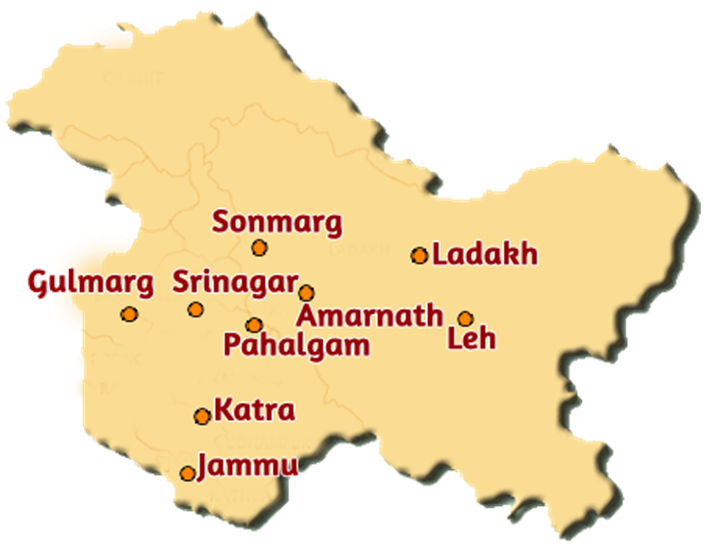
- Location and Geography:
- Pahalgam is a picturesque town in the Anantnag district of Jammu and Kashmir, nestled at an altitude of about 2,200 meters in the Lidder Valley, a tributary of the Jhelum River.
- Located around 95 km from Srinagar, it is a major tourist destination, known for trekking, river rafting, and trout fishing.
- It is also the starting point for the Amarnath Yatra, attracting thousands of Hindu pilgrims annually.
- Details of recent terror attack:
- On 22 April 2025, a group of four to six militants carried out a brutal attack on civilians at Baisaran meadow, a remote but popular site near Pahalgam.
- Dressed in military-style uniforms, the attackers posed as security personnel before opening fire indiscriminately. At least 28 people were killed, including 24 Indian tourists, 2 foreign nationals (from Nepal and the UAE), and 2 locals. Over 20 others were injured.
-
- According to survivors, victims were singled out based on religion—attackers demanded names, asked victims to recite the kalma, and checked for circumcision to identify and spare Muslims.
- Women were largely spared, with one assailant allegedly telling a woman she was left alive to “narrate the horrors” to Prime Minister Narendra Modi.
- The incident marks the deadliest civilian attack in the Kashmir Valley since the
abrogation of Article 370 in August 2019.
-
- The Resistance Front (TRF), a proxy of Pakistan-based Lashkar-e-Taiba, claimed responsibility, citing opposition to the settlement of "outsiders" in the region.
- Rise in militancy in Jammu & Kashmir (2021–2025):
- Despite an earlier decline, Jammu and Kashmir has witnessed a resurgence of militancy, particularly in the Jammu region, which remained largely peaceful for two decades.
- Key Patterns & Facts
- Jammu region witnessed 31 terror incidents since 2021, resulting in the deaths of 47 security personnel and 19 civilians.
- Kashmir Valley recorded 263 incidents, claiming 68 security forces and
75 civilians.
-
- Major affected areas include:
- Chenab Valley: Doda, Kishtwar, Ramban
- Pir Panjal Region: Rajouri and Poonch
- Major affected areas include:
- Reasons Behind the Resurgence:
- Thinning of Security Grid: After the 2020 Galwan clash, troops were redeployed to the China border, weakening internal security.
- Cross-Border Infiltration: 20–25 well-trained militants infiltrated via LoC, especially in Poonch-Rajouri and Kathua-Doda corridors.
- Challenging Topography: Dense forests and rugged terrain offer cover, aiding militant movement.
- Lack of Local Intelligence: Troop redeployment led to a vacuum in local surveillance.
- Technological Sophistication: Terrorists now use encrypted apps and social media for coordination.
- Trust Deficit with Civilians: Botched operations and rights violations have eroded local cooperation.
- Shift to Local Militants: Rising use of local youth as foot soldiers to mask Pakistan’s involvement.
- Emergence of New Groups: Multiple new outfits complicate intelligence operations.
-
- Political Targeting: Attacks are timed to disrupt elections and the narrative of restored peace post-Article 370.
- Government Response
- Zero-Tolerance Policy: Strict enforcement of anti-terror laws and coordinated crackdowns.
- Security Enhancements: Night patrols, drone surveillance, and proactive search operations.
- Intelligence Sharing: Greater inter-agency collaboration to preempt threats.
- Community Engagement: Efforts to reconnect with local communities, especially Gujjar-Bakarwals, for grassroots intelligence.
- Border Vigilance: Improved fencing and monitoring at the LoC and international border.
Jim Corbett Tiger Reserve
Why in news?
a. Corbett Tiger Reserve in Uttarakhand will install radio collars on tigers to monitor movements and reduce human-wildlife conflicts.
About Jim Corbett Tiger Reserve:
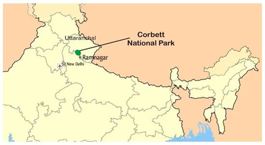
- Location and Geography:
-
- Jim Corbett Tiger Reserve, situated in Uttarakhand’s Nainital district, is India’s first national park, originally established in 1936 as Hailey National Park.
- It was renamed in 1956 after Jim Corbett, a British conservationist and hunter.
- The reserve spans 1,288.31 sq. km, including a core zone of 520.8 sq. km and a
buffer area of 466.31 sq. km.
-
- It lies between the Lesser Himalayas in the north and the Siwalik Hills in the south, encompassing features like hills, grasslands, ravines, and the Patli Dun valley formed by the Ramganga River.
- The elevation ranges from 360 to 1,040 meters, contributing to its rich ecological diversity.
- Flora and Fauna:
- The reserve is dominated by moist deciduous forests, primarily featuring sal, haldu, mango, peepal, and rohini trees.
- In total, there are 617 plant species, including 110 types of trees. Forests cover
73% of the park, with grasslands occupying 10%.
-
- Jim Corbett hosts over 50 species of mammals, 580 species of birds, and 25 species of reptiles.
- It is home to flagship species like the Bengal tiger, Indian elephant, leopard, sloth bear, chital, and crocodiles.
- As per the 2022 tiger census, the park shelters around 260 tigers, making it one of the densest tiger habitats in India.
- The elephant population was estimated at around 1,100 in 2019.
- Human-Wildlife Conflict:
- The rise in human-wildlife conflict is attributed to factors like habitat encroachment, expanding human settlements, and unregulated ecotourism.
- Wildlife corridors have been disrupted by infrastructure and increasing vehicular traffic, pushing animals like tigers and elephants closer to human populations.
- Instances of livestock predation, crop raiding, and occasional attacks on humans have increased. In response, authorities have begun fitting radio collars on tigers to monitor their movements and mitigate conflict.
- Ecotourism and Conservation:
- Jim Corbett is a popular ecotourism destination. While tourism has brought economic benefits to local communities, it has also led to environmental degradation.
- Issues include soil compaction, vegetation loss, fuelwood collection, littering, and noise pollution.
- Despite these challenges, the reserve continues to play a vital role in Project Tiger. It is part of the Terai Arc Landscape Program, aimed at restoring
wildlife corridors across northern India and Nepal for the tiger, elephant, and
rhinoceros.
Salal Dam
Why in news?
a. Salal Dam authorities opened spillway gates as heavy rainfall caused water levels in the Chenab River to rise significantly.
About Salal Dam:
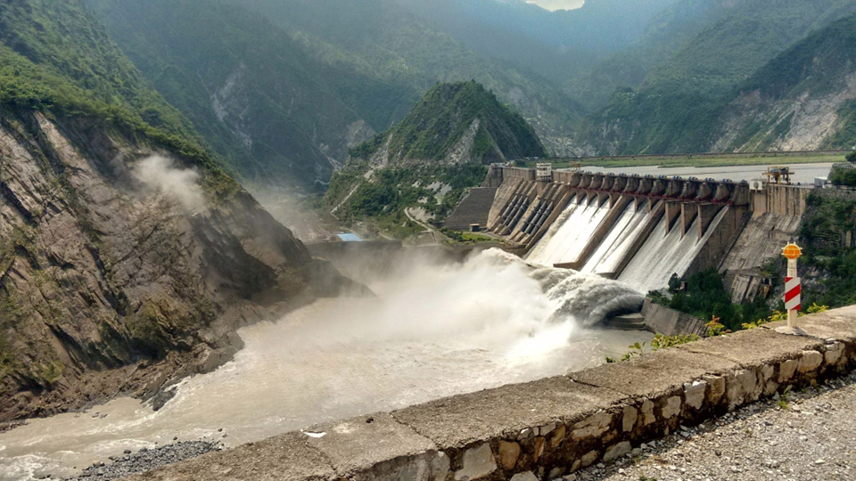
- Location and Geography:
- The Salal Dam, also known as the Salal Hydroelectric Power Station, is a run-of-the-river hydroelectric project located on the Chenab River in the Reasi district of Jammu and Kashmir.
- It lies near Salal village, a few kilometers south of Matlot, where the river takes a southerly turn.
- The Marala Headworks in Pakistan is located 72 km downstream, from where Pakistan diverts water via major canals.
- Historical and Strategic Significance:
-
- The project was conceived in 1920, with feasibility studies initiated in 1961 and a final design prepared by 1968.
- Construction started in 1970 by the Central Hydroelectric Project Control Board under the Ministry of Irrigation and Power.
- It was the first hydroelectric project in Jammu and Kashmir built under the Indus Water Treaty.
|
Also Read |
|
| NCERT Books For UPSC | |
| UPSC Monthly Magazine | Best IAS Coaching in Delhi |


PLACES IN NEWS 10th MAY 2025

PLACES IN NEWS 9th MAY 2025

PLACES IN NEWS 8th MAY 2025
Karol Bagh Metro Pillar No. 112, Above Domino's, 22B, First Floor, New Delhi - 110060
Very Important Instruction For Any Issue, Student Must Produce His/Her Fee Receipt. Without Fee Receipt, It Will Not Be Possible To Track Your Details. If You Have Been Given Any Special Consideration, You Must Keep That In Writing And Produce In Case Of Conflict.
Copyright © 2024-2026 ENSURE IAS. All rights reserved.