- Courses
- GS Full Course 1 Year
- GS Full Course 2 Year
- GS Full Course 3 Year
- GS Full Course Till Selection
- Online Program
- GS Recorded Course
- NCERT (Recorded 500+ Hours)
- Polity Recorded Course
- Geography Recorded Course
- Economy Recorded Course
- AMAC Recorded Course
- Modern India, Post Independence & World History
- Environment Recoded Course
- Governance Recoded Course
- Science & Tech. Recoded Course
- International Relations and Internal Security Recorded Course
- Disaster Management Module Course
- Ethics Recoded Course
- Essay Recoded Course
- Current Affairs Recoded Course
- CSAT
- 5 LAYERED ARJUNA Mentorship
- Public Administration Optional
- ABOUT US
- OUR TOPPERS
- TEST SERIES
- FREE STUDY MATERIAL
- VIDEOS
- CONTACT US
PLACES IN NEWS 10th APRIL 2025
PLACES IN NEWS 10th APRIL 2025
10-04-2025

Taiwan Strait
Why in news?
- China launched military drills in the Taiwan Strait, signalling pressure on Taiwan amid rising tensions and increasing U.S.-Taiwan ties.
About Taiwan Strait:
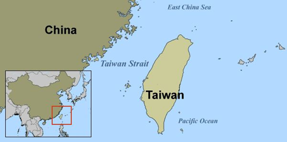
- Location:
- The Taiwan Strait is a 180-kilometre-wide body of water that separates Taiwan from the south-eastern coast of mainland China, primarily the Fujian province.
- It connects the East China Sea in the north to the South China Sea in the south, making it a vital maritime link in East Asia.
- The strait is a crucial passage for regional and global shipping, with numerous vessels transiting daily through its waters for trade and energy supply routes.
- Geostrategic Importance:
- Trade and Maritime Route: The Taiwan Strait is part of key international shipping lanes. Disruption in this route can impact global trade, especially the flow of semiconductors and electronic components from Taiwan.
- Military and Strategic Significance: Control over the Taiwan Strait offers strategic leverage in East Asia. China views the strait as part of its internal waters, while Taiwan and many Western nations, including the U.S., consider it international waters. This dispute enhances its geopolitical sensitivity.
- Cross-Strait Relations and Regional Tensions: The strait lies at the heart of China-Taiwan tensions. China considers Taiwan a breakaway province, while Taiwan asserts its democratic self-governance. The growing U.S.-Taiwan defence cooperation and frequent arms sales to Taiwan have further strained the situation, prompting Chinese military drills and aerial incursions near the strait as a show of force.
- Flashpoint of US-China Rivalry: The Taiwan Strait has become a symbol of the wider strategic rivalry between the U.S. and China. The U.S. supports Taiwan through the Taiwan Relations Act and naval transits through the strait, which China views as interference in its sovereignty. This has led to increasing militarisation and frequent military standoffs in the region.
- Global Stability and Security: Any conflict in the Taiwan Strait could escalate quickly, involving global powers and destabilising the Indo-Pacific region. It is, therefore, a critical point for maintaining peace and stability in East Asia.
Agasthyamalai Biosphere Reserve
Why in news?
- The Supreme Court has directed the Central Empowered Committee (CEC) to carry out a detailed survey of the Agasthyamalai Biosphere Reserve to detect encroachments and unauthorized non-forestry activities.
About Agasthyamalai Biosphere Reserve:

- Location and Geography:
- The Agasthyamalai Biosphere Reserve is situated at the southernmost tip of the Western Ghats, a globally recognised biodiversity hotspot.
- It spans the states of Kerala (Thiruvananthapuram and Kollam districts) and Tamil Nadu (Tirunelveli and Kanniyakumari districts).
- The reserve covers an area of around 3,500 square kilometres, encompassing evergreen, semi-evergreen, and montane forests.
- The region includes prominent protected areas such as the Periyar Tiger Reserve (Kerala), Srivilliputhur Grizzled Squirrel Wildlife Sanctuary, Kalakkad-Mundanthurai Tiger Reserve (Tamil Nadu), and Neyyar, Peppara, and Shendurney Wildlife Sanctuaries.
- Ecological Features:
- Flora: The biosphere is home to over 2,254 species of plants, including 405 endemic species. It also harbours rare medicinal herbs that hold significant value in Ayurveda.
- Fauna: The reserve supports 79 species of mammals, including 20 endemic species such as tigers, elephants, and the grizzled giant squirrel.
- Avifauna: Approximately 337 bird species are recorded here, with 20 being endemic to the region.
- Reptiles and Amphibians: There are 88 reptile and 45 amphibian species, many of which exhibit high levels of endemism.
- Cultural and Indigenous Significance:
- The reserve is home to the Kani tribe, with a population of around 30,000. They are known for their traditional ecological knowledge and sustainable resource use practices.
- Agasthyamalai holds religious and cultural importance, being associated with Sage Agastya, a revered figure in Hindu mythology and Ayurvedic medicine.
- Regulatory Framework and Conservation Measures:
- Biosphere Reserves in India are governed under the Man and the Biosphere (MAB) Programme and national environmental laws.
- To protect their integrity, non-forestry activities such as encroachments, illegal constructions, and commercial exploitation are strictly regulated or prohibited.
- The region is divided into core, buffer, and transition zones, with the core areas being fully protected from human interference to conserve biodiversity.
Chittorgarh Fort
Why in news?
- Rajasthan informed the Supreme Court it is considering a mining ban within 10 km of Chittorgarh Fort to protect heritage.
About Chittorgarh Fort:
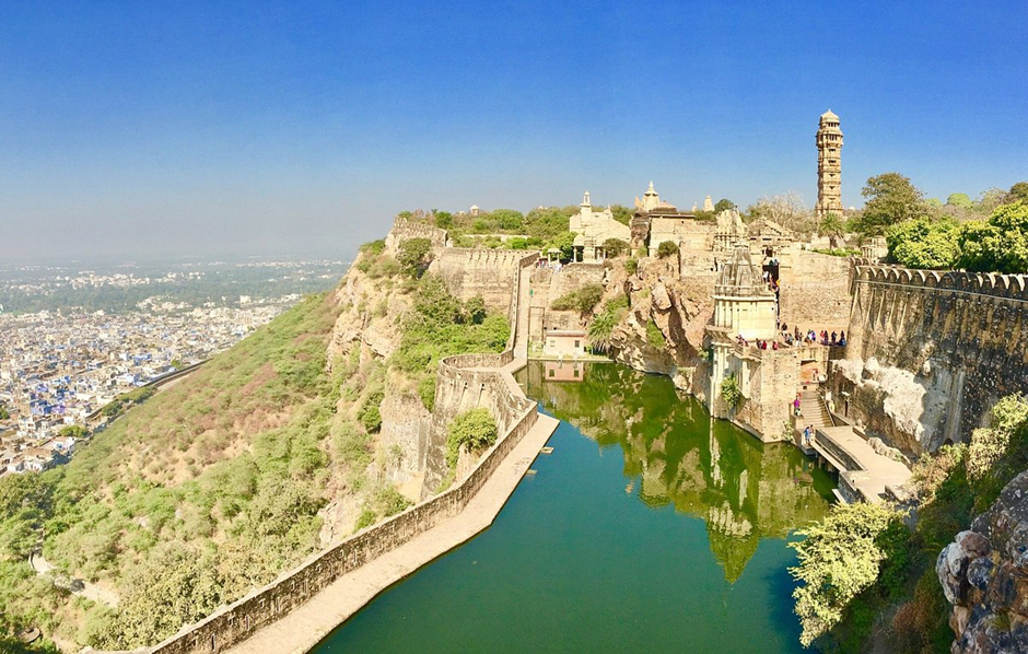
- Location:
- Chittorgarh Fort is located in the Chittorgarh district of Rajasthan, perched on a 180-metre-high hill near the banks of the Berach River.
- Sprawling across 700 acres with a 13 km circumference, it is among the largest forts in India.
- Historical and Cultural Significance:
- Constructed in the 7th century A.D. by Chitrangada Mori, a local Maurya ruler, the fort later came under the control of the Sisodia Rajputs of Mewar in 728 CE.
- It served as the capital of Mewar and played a vital role in the history of Rajput resistance against invading armies.
- The fort has witnessed the heroism of legendary figures such as Maharana Pratap, Rana Kumbha, Jaimal, Patta, Gora, and Badal.
- Designated as a UNESCO World Heritage Site (WHS) in 2013, Chittorgarh Fort is recognised for its exceptional cultural and architectural value.
- It features seven massive gates—including the Ram Pol (main gate)—designed to defend against enemy invasions.
- The fort’s structure, built with lime mortar, rises 500 metres above ground level.
- Inside the fort are four palaces, 19 temples (both Hindu and Jain), 20 water bodies, and four memorials, showcasing its spiritual and cultural richness.
- The annual Jauhar Mela, held at the fort, commemorates the jauhar of Rani Padmini, where Rajput women chose self-immolation over dishonour during invasions, symbolising purity and valour in Rajput tradition.
- Reason Behind the Mining Ban:
- To preserve this historical marvel, the Supreme Court recently directed action to prevent damage from mining and blasting activities in the surrounding region.
- The Rajasthan government informed the court that it is considering a ban on mining within a 10 km radius of the fort.
- The move aims to safeguard the structural integrity of the monument, which is threatened by vibrations from mining blasts.
- Given its World Heritage Site status and deep cultural significance, protecting Chittorgarh Fort is vital for heritage conservation and for honouring the legacy of Rajputana courage and sacrifice.
Godavari River
Why in news?
- The Maharashtra Navnirman Sena has urged authorities to clean the Godavari River ahead of the 2027 Kumbh Mela to ensure environmental sanctity.
About Godavari River:
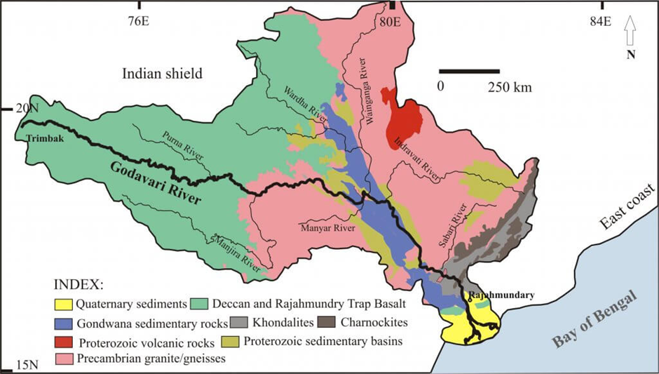
- Origin and Course:
- The Godavari River, often referred to as the Dakshina Ganga (Southern Ganges), is the second longest river in India after the Ganga.
- Originating from Trimbakeshwar in Nashik district, Maharashtra, it flows eastwards for about 1,465 km across the Deccan Plateau and empties into the Bay of Bengal near Yanam (Puducherry UT), forming a vast delta.
- Covering a drainage basin of 312,812 km², the river traverses Maharashtra, Telangana, Andhra Pradesh, Chhattisgarh, and Odisha, draining about 10% of India's land area.
- It is divided into upper, middle, and lower basins, governed by the Godavari Water Disputes Tribunal for interstate water sharing.
- The river has several important tributaries. On the left bank: Purna, Pranhita, Indravati, and Sabari—with Pranhita contributing the largest sub-basin.
- On the right bank: Pravara, Manjira, and Manair.
- These tributaries enhance the river's water volume, making it crucial for irrigation, drinking water, and hydropower projects, including the Jayakwadi, Sriram Sagar, Polavaram, and Dowleswaram dams.
- Cultural and Religious Significance:
- The Godavari is considered sacred in Hinduism. The Kumbh Mela at Nashik is a major religious congregation on its banks.
- Towns like Nashik, Nanded, Bhadrachalam, and Rajamahendravaram are prominent pilgrimage centres.
- The river’s seven distributaries near its mouth are traditionally associated with the Sapta Rishis, giving it deep mythological relevance.
- Economic and Ecological Significance:
- The basin is vital for agriculture, fisheries, and transportation. The river provides water to drought-prone areas of Marathwada and Telangana and supports major irrigation and lift projects like Kaleshwaram.
- The river passes through biodiversity-rich zones like the Papi Hills, Eastern Ghats, and mangrove ecosystems near the delta. However, the river faces environmental stress due to damming, pollution, and reduced seasonal flow.
Kaziranga National Park
Why in news?
- Ex-Cricketer Sachin Tendulkar recently explored Kaziranga National Park, feeding elephants and experiencing a jeep safari.
About Kaziranga National Park:
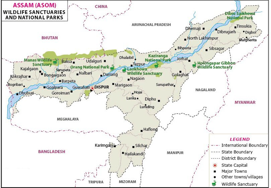
- Location:
- Kaziranga National Park is located in the northeastern state of Assam, India, along the southern bank of the Brahmaputra River.
- It spans across the Golaghat and Nagaon districts and covers an area of approximately 1,030 square kilometres, making it one of the largest national parks in India.
- Kaziranga is situated in a floodplain and is bounded by the Karbi Anglong Hills to the south, contributing to its unique geographic and ecological diversity.
- Biodiversity:
- Kaziranga is renowned for its rich biodiversity, primarily as the habitat of the endangered Indian rhinoceros, which constitutes about 70% of the world's population of this species.
- The park is home to over 2,000 species of plants, more than 500 species of birds, and 100 species of mammals, including the Bengal tiger, wild buffalo, and elephants.
- The ecosystem is a mix of tall grasslands, wetlands, and forested areas, which support a wide variety of flora and fauna, making it a UNESCO World Heritage Site.
- Key Features:
- World Heritage Site: Kaziranga was declared a UNESCO World Heritage Site in 1985 due to its exceptional biodiversity and the critical role it plays in the conservation of the Indian rhinoceros and other endangered species.
- Conservation Efforts: The park has been the focus of extensive conservation efforts, including anti-poaching measures and habitat restoration projects, which have helped increase the populations of species like the Indian rhinoceros and tigers.
- Tourism and Accessibility: Kaziranga is a major eco-tourism destination, attracting visitors for its jeep safaris and elephant rides, where tourists can observe wildlife in their natural habitat.
- Flood Management: The park experiences annual flooding due to the Brahmaputra River, which replenishes the ecosystem but also presents challenges for wildlife conservation during the monsoon season.
|
Also Read |
|
UPSC Foundation Course |
|
| UPSC Monthly Magazine | CSAT Foundation Course |


Anti-Submarine Warfare Shallow Water Craft INS Arnala

Astronomers Detect Eleven New Active Galactic Nuclei

Scientists Make Strange 2d Metals Sought for Future Technologies
Karol Bagh Metro Pillar No. 112, Above Domino's, 22B, First Floor, New Delhi - 110060
Copyright © 2024-2026 ENSURE IAS. All rights reserved.