- Courses
- GS Full Course 1 Year
- GS Full Course 2 Year
- GS Full Course 3 Year
- GS Full Course Till Selection
- Online Program
- GS Recorded Course
- NCERT (Recorded 500+ Hours)
- Polity Recorded Course
- Geography Recorded Course
- Economy Recorded Course
- AMAC Recorded Course
- Modern India, Post Independence & World History
- Environment Recoded Course
- Governance Recoded Course
- Science & Tech. Recoded Course
- International Relations and Internal Security Recorded Course
- Disaster Management Module Course
- Ethics Recoded Course
- Essay Recoded Course
- Current Affairs Recoded Course
- CSAT
- 5 LAYERED ARJUNA Mentorship
- Public Administration Optional
- ABOUT US
- OUR TOPPERS
- TEST SERIES
- FREE STUDY MATERIAL
- VIDEOS
- CONTACT US
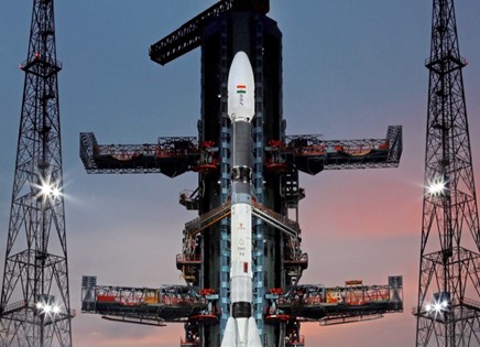
ISRO’S NEW NavIC SATELLITE NVS-01
ISRO’S NEW NavIC SATELLITE NVS-01

Latest Context
Recently, the Indian Space Research Organisation (ISRO) launched its satellite the NVS-01 by using the GSLV-F12. It was accurately placed into a Geosynchronous Transfer Orbit after a 19-minute flight.
Key Facts: GSLV-F12 is the 15th flight of India’s GSLV (Geosynchronous Satellite Launch Vehicle) and the 9th flight with an indigenous cyro stage. It is the 6th operational flight of a GSLV with an indigenous cryogenic stage.
Features of NVS-01
- Concept: It is the first of the second-generation satellites of ISRO’s NVS (Navigational Satellite) series of payloads. It is the heaviest constellation having a weight of 2,232 kg. It carried navigation payloads L1, L5 and S bands.
- Objective: Its aim is to provide continuity for the NavIC (Navigation in Indian Constellation) services. It is an Indian Regional Navigation Satellite System (similar to GPS) that provides accurate and real-time navigation within India and up to a 1,500 km region around the country. There are seven satellites in the Indian Regional Navigation Satellite System (IRNSS) constellation, operationally named NavIC, weighing much less — around 1,425 kg — at liftoff in the first generation.
- Atomic Clock: It will have a Rubidium atomic clock onboard which is a significant technology developed by India. Due to failed atomic clocks, some of the existing satellites in the navigation constellation lost their ability to provide accurate location data. Satellite-based positioning systems rely on precise time measurements from atomic clocks to determine object locations. In case clocks do not function properly, they cannot provide exact information of location anymore.
- L1 Signals: It will send signals in a third frequency, L1, besides the L5 and S frequency signals that the existing satellites provide, increasing interoperability with other satellite-based navigation systems. It is most commonly used in the Global Positioning System (GPS). In addition, it will increase the use of regional navigation systems in wearable devices and personal trackers which are used in low-power, single-frequency chips.
- Longer Mission Life: More than 12 years will be its mission life. Presently, the mission life of existing satellites is 10 years.
Features of Navigation in Indian Constellation (NavIC)
Concept: It is structured with a constellation of 7 satellites and a network of ground stations operating 24×7. There are a total of eight satellites but only seven are active. Out of seven, three satellites are in geostationary orbit and four satellites are in geosynchronous orbit. On 1st July 2013, the first satellite of constellations was launched and the eighth satellite IRNSS-1I was launched in April 2018.
- IRNSS was renamed NavIC by India’s Prime Minister in 2016 with the seventh launch of the constellation's satellite (IRNSS-1G). International Maritime Organization (IMO) recognised it as a part of the World-Wide Radio Navigation System (WWRNS) for operation in the Indian Ocean Region in 2020.
Application of Navigation in Indian Constellation (NavIC)
- Integration with mobile phones;
- Accurate timing (as for ATMs and power grids);
- Mapping and geodetic data capture.
- Terrestrial, aerial and marine navigation;
- Disaster management;
- Vehicle tracking and fleet management (especially for the mining and transportation sector);
Benefits of Regional Navigation System
- Regional Navigation System: NavIC is India's own regional navigation system developed by ISRO. It covers the Indian landmass extending up to 1500 km. The fundamental objective of NavIC is to fulfil the positioning and navigation needs of users in this specific region.
- Ground Stations: ISRO is constantly functioning for establishing ground stations in countries such as Russia. France, and Japan. They will increase the exactness and coverage area of NavIC signals through better triangulation.
- Signal Reception: At a 90-degree angle, NavIC signals reach India enabling the signals to penetrate congested areas, dense forests, and mountainous terrain. On the contrary, by arriving at an angle, GPS signals can sometimes pose challenges for reception in certain locations.
- Availability: They are basically designed to serve the Indian region. Therefore, users can expect reliable access to NavIC signals within the coverage area even in remote or hard-to-reach areas.
Other Navigation Systems operational in the world
Four Global Systems:
- GPS from the U.S.
- GLONASS from Russia.
- Galileo from European Union
- BeiDou from China.
Two Regional Systems:
- NavIC from India
- QZSS from Japan.

Q.1 Which one of the following countries has its own Satellite Navigation System? (2023)
a. Australia
b. Canada
c. Israel
d. Japan
Ans: d
Q.2 With reference to the Indian Regional Navigation Satellite System (IRNSS), consider the following statements: (2018)
1. IRNSS has three satellites in geostationary and four satellites in geosynchronous orbits.
2. IRNSS covers entire India and about 5500 sq. Km beyond its borders.
3. India will have its own satellite navigation system with full global coverage by the middle of 2019.
Which of the statements given above is/are correct?
(a) 1 only
(b) 1 and 2 only
(c) 2 and 3 only
(d) None
Ans: (a)
Mains
Q.1 Why is Indian Regional Navigational Satellite System (IRNSS) needed? How does it help in navigation? (2018)
Anti-Submarine Warfare Shallow Water Craft INS Arnala

Astronomers Detect Eleven New Active Galactic Nuclei

Scientists Make Strange 2d Metals Sought for Future Technologies
Karol Bagh Metro Pillar No. 112, Above Domino's, 22B, First Floor, New Delhi - 110060
Copyright © 2024-2026 ENSURE IAS. All rights reserved.