- Courses
- GS Full Course 1 Year
- GS Full Course 2 Year
- GS Full Course 3 Year
- GS Full Course Till Selection
- Online Program
- GS Recorded Course
- NCERT (Recorded 500+ Hours)
- Polity Recorded Course
- Geography Recorded Course
- Economy Recorded Course
- AMAC Recorded Course
- Modern India, Post Independence & World History
- Environment Recoded Course
- Governance Recoded Course
- Science & Tech. Recoded Course
- International Relations and Internal Security Recorded Course
- Disaster Management Module Course
- Ethics Recoded Course
- Essay Recoded Course
- Current Affairs Recoded Course
- CSAT
- 5 LAYERED ARJUNA Mentorship
- Public Administration Optional
- ABOUT US
- OUR TOPPERS
- TEST SERIES
- FREE STUDY MATERIAL
- VIDEOS
- CONTACT US
Government to make NaVIC mandatory in all devices
Government to make NaVIC mandatory in all devices

Latest Context:
Mandatory Integration of India's Navigation System (NavIC) in All Devices.
Introduction:
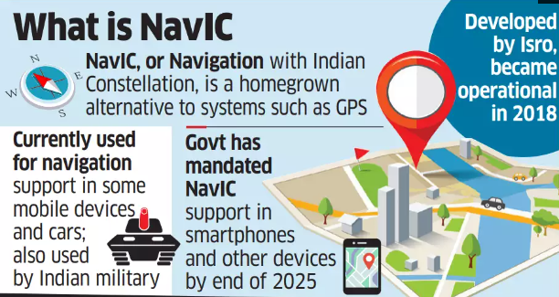
In a transformative move, the Indian government has announced its decision to mandate the use of the Indian Constellation of Navigation (NavIC) in all devices. This significant shift comes as an alternative to the prevalent reliance on the USA's Global Positioning System (GPS) for navigation purposes. NavIC, developed by the Indian Space Research Organization (ISRO), is a homegrown navigation satellite system comprising seven satellites, ready to revolutionize the navigation landscape.
NavIC: An Overview
NavIC, formerly known as the Indian Regional Navigation Satellite System, is a self-contained navigation system comprising seven satellites. Among these, four satellites are positioned in geostationary orbit, while the remaining three operate in inclined geosynchronous orbit. The system extends its coverage to encompass the entire landmass of India, extending up to 1,500 kilometres (930 miles) beyond its borders.
NavIC's Advantages Over GPS:
The transition to NavIC is driven by several notable advantages it offers over GPS:
- Enhanced Positioning Accuracy: NavIC boasts an impressive positioning accuracy of 10 meters, surpassing GPS's 20-meter accuracy. This improvement is attributed to NavIC's utilization of dual-frequency bands within the spectrum.
- Reduced Signal Blockages: NavIC's satellite positioning, situated at a higher altitude above the Earth's surface, significantly diminishes signal interruptions in challenging terrains such as the Himalayan mountains and other terrestrial obstacles.
The Necessity for NavIC Integration:
The government's decision to make NavIC mandatory serves various strategic and practical purposes:
- Promoting Local Industry: By mandating NavIC integration, the government seeks to encourage the development and growth of local industries that rely on NavIC-based solutions, fostering technological innovation and self-reliance.
- Facilitating Drone Usage: NavIC's precise navigation capabilities will simplify and enhance the utilization of drones for logistics, surveillance, and various applications.
- Supporting National Policies: The move aligns with India's Shakti Plan and logistic policy, streamlining the adoption of advanced navigational technologies for strategic purposes and national development.
- Reducing Foreign Dependency: By reducing reliance on foreign satellite systems, India gains greater autonomy and security in strategic positioning.
Applications of NavIC:
NavIC's applications extend across diverse domains, including terrestrial, aerial, and marine navigation, disaster management, precise timing for various sectors, scientific research, and more.
Global Navigation Systems:
Besides NavIC, several other navigation systems operate globally:
- Russia's GLONASS: Russia's Global Navigation Satellite System provides global coverage and positioning services.
- Europe's Galileo: The European Union's Galileo navigation system offers independent and precise positioning for various applications.
- China's Beidou: China's Beidou navigation system, now known as BDS, rivals GPS and offers global navigation services.
- Japan's QZSS: Japan's Quasi-Zenith Satellite System (QZSS) augments GPS signals over the country, ensuring enhanced accuracy and coverage.
Conclusion:
The government's decision to make NavIC integration mandatory in all devices marks a pivotal moment in India's technological evolution. This homegrown navigation system promises enhanced accuracy, reduced signal blockages, and strategic independence. As India forges ahead on its path of self-reliance and technological advancement, NavIC stands as a beacon of innovation and progress. For UPSC aspirants, understanding this paradigm shift is essential as it reflects India's commitment to technological prowess and strategic autonomy in the navigation sphere.
Q: In which of the following domains can NavIC be applied?
a) Space exploration
b) Underwater archaeology
c) Terrestrial, aerial, and marine navigation
d) Music composition
Correct Answer: c) Terrestrial, aerial, and marine navigation
Must Check: Best IAS Coaching In Delhi

Anti-Submarine Warfare Shallow Water Craft INS Arnala

Astronomers Detect Eleven New Active Galactic Nuclei

Scientists Make Strange 2d Metals Sought for Future Technologies
Karol Bagh Metro Pillar No. 112, Above Domino's, 22B, First Floor, New Delhi - 110060
Copyright © 2024-2026 ENSURE IAS. All rights reserved.