- Courses
- GS Full Course 1 Year
- GS Full Course 2 Year
- GS Full Course 3 Year
- GS Full Course Till Selection
- CSAT
- 5 LAYERED ARJUNA Mentorship
- Public Administration Optional
- Online Program
- GS Recorded Course
- NCERT Batch
- Polity Module Course
- Geography Module Course
- Economy Module Course
- AMAC Module Course
- Modern India, Post Independence & World History Module Course
- Environment Module Course
- Governance Module Course
- Science & Tech. Module Course
- International Relations and Internal Security Module Course
- Disaster Management Module Course
- Ethics Module Course
- Essay Module Course
- Current Affairs Module Course
- ABOUT US
- OUR TOPPERS
- TEST SERIES
- FREE STUDY MATERIAL
- VIDEOS
- CONTACT US
PLACES IN NEWS 15th APRIL 2025
PLACES IN NEWS 15th APRIL 2025
15-04-2025

Hudson River
Why in news?
- Experts suspect that 'mast bumping' may have caused the recent helicopter crash into Manhattan’s Hudson River, resulting in tragedy.
About Hudson River:
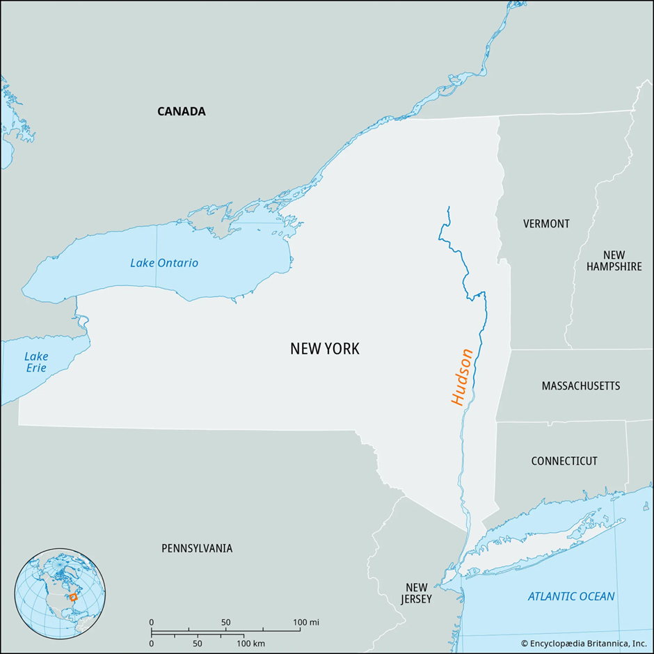
- The Hudson River is located in New York State, United States.
- It flows almost entirely within New York State, except for its final 21 miles (34 km), where it forms the boundary between New York and New Jersey.
- The river is named after Henry Hudson, an English sea explorer.
- It originates from several small postglacial lakes in the Adirondack Mountains, near Mount Marcy, the highest point in New York (1,629 metres).
- The main headstream of the Hudson River is the Opalescent River, originating from Lake Tear of the Clouds.
- The river flows approximately 315 miles (507 km) through the eastern part of New York.
- It drains an area of 34,628 square kilometres.
- The Hudson River empties into the Upper New York Bay, which is part of the larger New York Harbour.
- The river has been historically significant for transportation and trade in the region.
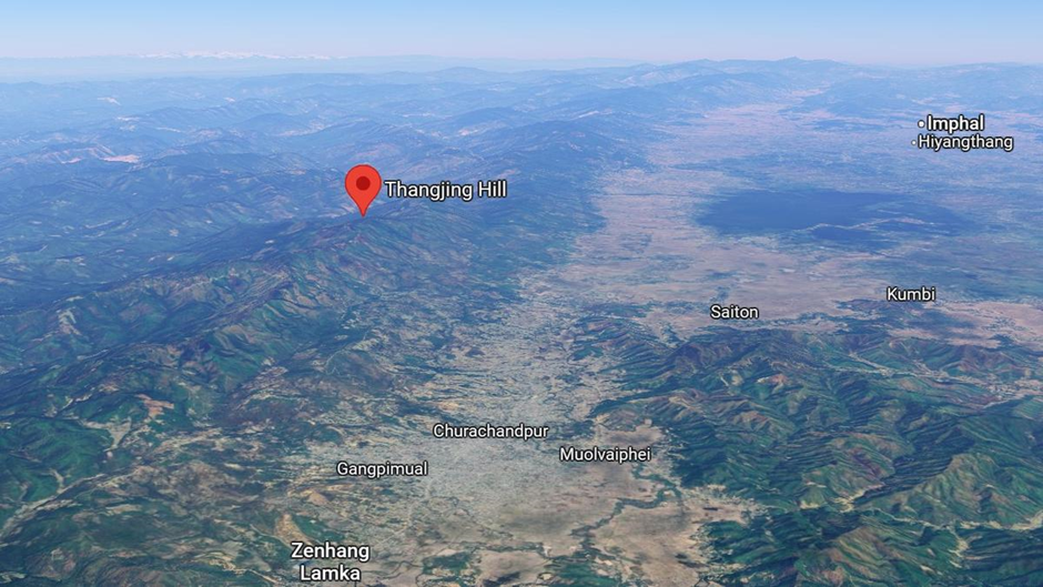
Thangjing Hill
Why in news?
- Kuki groups in Manipur have issued warnings to Meitei communities against climbing the sacred Thangjing Hill due to tensions.
About Thangjing Hill:
-
Location and Geography:
- Thangjing Hill is located in the Churachandpur district of the Indian state of Manipur, to the west of Moirang.
- The hill is part of the Thangjing Range or Thangjing Hills, which runs in a north-south direction and forms part of the western border of the Imphal Valley.
- The hill reaches an elevation of approximately 2,100 metres (6,900 feet) above sea level.
- The western slopes of the hill are in the Henglep Subdivision (also known as Henglep block), while the eastern slopes are in the Kangvai Subdivision.
- Various streams originating from the hill, including the Leimatak River and Tuila River, flow into major rivers such as the Irang River and Tuivai River.
- The Lanva River to the southeast flows south until Songpi, where its course is deflected by a ridge, eventually draining into the Khuga River near Churachandpur town.
-
Cultural and Religious Significance:
- Thangjing Hill holds immense cultural and religious significance for the Meitei people of Manipur, particularly the Moirang region.
- The hill is considered the abode of Thangching, the ancestral deity of Moirang, and is believed to represent the right leg of the Meitei cosmology that symbolises the body of Manipur.
- Pilgrimages to the hill are an annual tradition for the Meiteis of the Moirang region, as they seek blessings from the deity.
- The hill is also central to Meitei mythology, where the deity Eputhou Thangjing is regarded as the guardian of the hill and protector of the southern part of the Kanglei world. The hill features in the famous love story of Khamba and Thoibi.
-
Meitei-Kuki Conflict:
- Thangjing Hill lies within the region dominated by the Kuki-Zo people, particularly in Churachandpur district, a predominantly Kuki area.
- The sacred status of Thangjing Hill, closely tied to Meitei traditions, has become a point of contention between the Meitei and Kuki communities, leading to tensions in the region.
- The hill’s religious importance for the Meiteis has been met with resistance from the Kuki groups, who have raised concerns about the Meitei community’s increasing presence and pilgrimages to the hill.
Rajaji Tiger Reserve
Why in news?
- The government emphasizes the need to enhance promotion of Rajaji Tiger Reserve as a significant tourism destination to boost visitation.
About Rajaji Tiger Reserve:
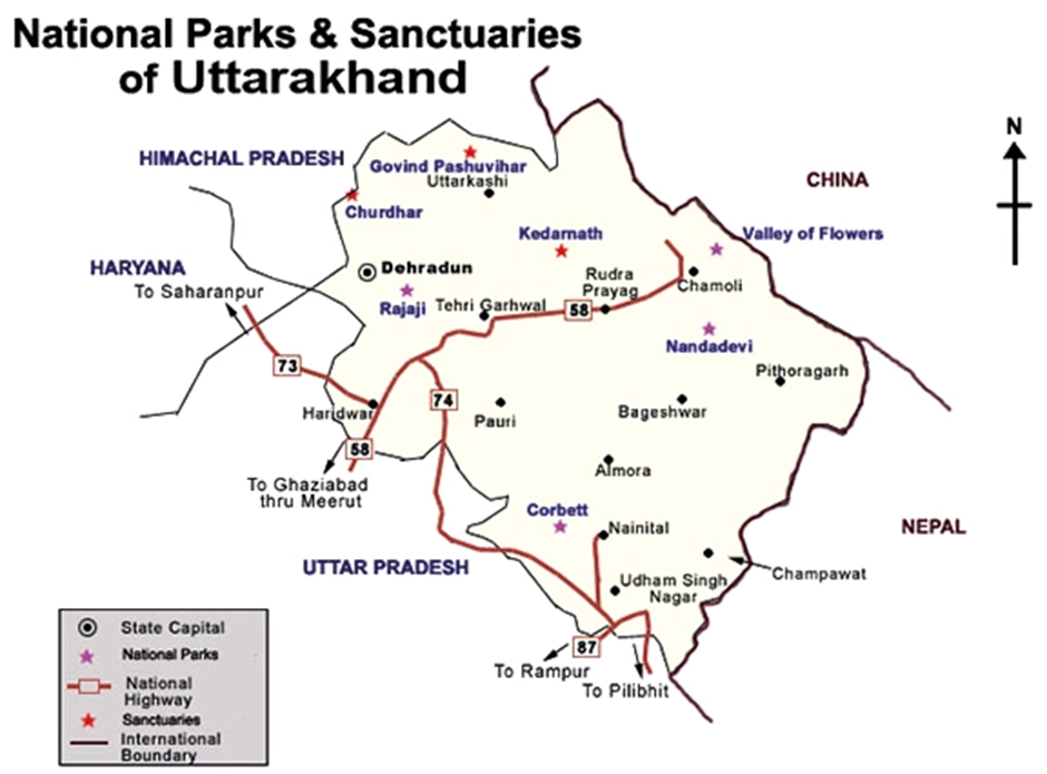
1. Location and Geography:
- Rajaji National Park is located in the Sivalik Hills, spanning across three districts of Uttarakhand: Haridwar, Dehradun, and Pauri Garhwal.
- The park covers an area of 820 km² (320 sq mi), and its elevation ranges from 300 to 1400 meters above sea level.
- The Ganga River flows through the park, dividing it into two parts: the western Rajaji and Motichur Sanctuary on one side and the eastern Chilla Sanctuary on the other.
- The park was formed by merging the Rajaji, Motichur, and Chilla sanctuaries in 1983 and was later declared a tiger reserve in 2015.
2. Flora and Fauna:
- The park boasts diverse flora, ranging from broadleaved deciduous forests to riparian vegetation (near rivers), shrublands, grasslands, and pine forests.
- Common plant species include rohini, amaltas, sal, palash, and khair, which contribute to the rich biodiversity of the park.
- Rajaji Tiger Reserve is renowned for its wildlife, hosting species such as the Indian elephant, Bengal tiger, Indian leopard, and a variety of deer species like Chital and Sambar.
- Other prominent animals include the sloth bear, Asian black bear, wild boar, and rhesus macaque. The park is also home to species like goral and Himalayan tahr, which inhabit the park's steep slopes.
- The reserve has over 315 species of birds, including the peafowl, red jungle fowl, woodpeckers, and vultures like the Egyptian and Himalayan vultures.
Tawi River
Why in news?
- J&K Lt Governor Manoj Sinha described the Tawi River as the soul of Jammu, emphasizing its cultural significance.
About Tawi River:
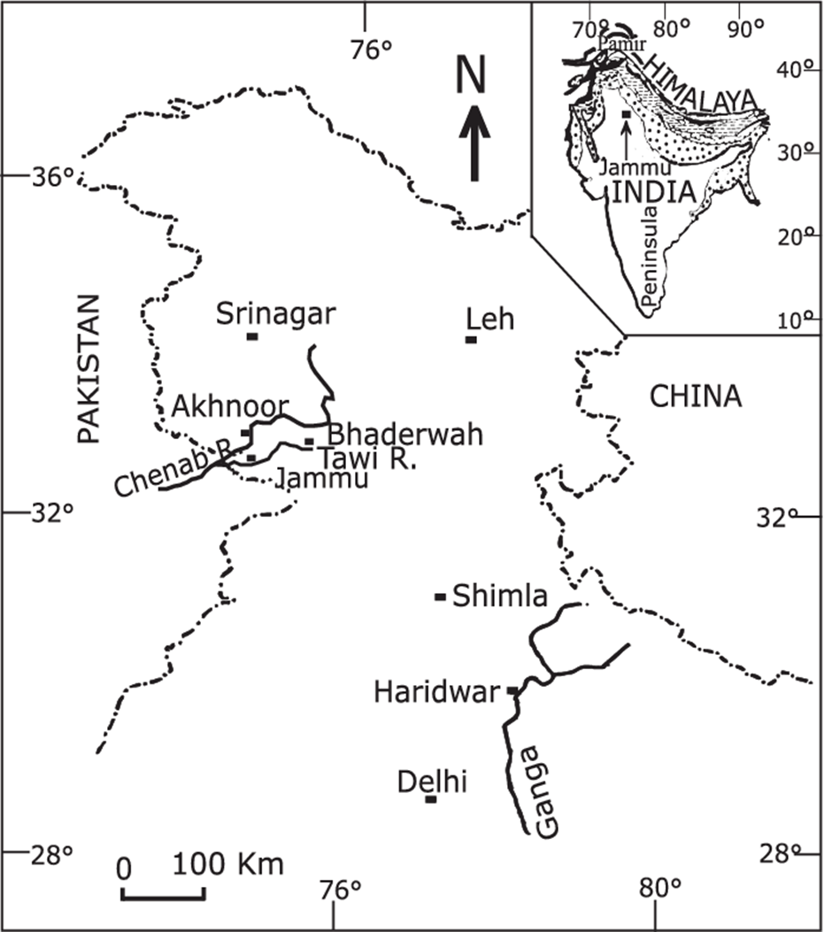
1. Origin and Course:
- The Tawi River originates from the Kailash Kund Glacier (also known as Kali Kund) in the Bhaderwah region of Doda district, Jammu and Kashmir.
- It flows through the Jammu region in Indian-administered Jammu and Kashmir and later enters Pakistan-administered Azad Jammu and Kashmir.
- The total length of the Tawi River is approximately 141 km, with a catchment area of around 2,168 km² (within Indian territory).
- It generally flows through steep hilly terrain, except for the last 35 km, which pass through relatively flatter land near Jammu city.
- Within Jammu, the river is about 300 metres wide, and key infrastructure like the Gujjar Nagar bridge (90 metres high) spans across it.
- After flowing through Jammu city, the river crosses into Pakistan’s Punjab province, where it eventually merges with the Chenab River, a major tributary of the Indus system.
2. Ecological and Cultural Significance:
- The Tawi is considered sacred and is often referred to as "Suryaputri" or the Daughter of the Sun God.
- It holds deep religious and mythological importance among the people of Jammu. As per local legend, King Raja Pehar Devta brought the river to the region to cure his ailing father.
- The river is central to cultural festivals, religious rituals, and daily life, especially in Jammu city.
- Despite its significance, the river faces serious threats from pollution, declining water levels, and urban encroachment, putting its ecological balance at risk.
- To address these concerns, the government of Jammu & Kashmir is implementing an artificial lake project at Bhagwati Nagar to boost tourism, enhance water supply, and aid urban development.
- The project has been reviewed by Pakistani officials to ensure compliance with the Indus Waters Treaty.
|
Also Read |
|
| FREE NIOS Books | |


PLACES IN NEWS 19th APRIL 2025

PLACES IN NEWS 18th APRIL 2025

PLACES IN NEWS 17th APRIL 2025
Karol Bagh Metro Pillar No. 112, Above Domino's, 22B, First Floor, New Delhi - 110060
Copyright © 2024-2026 ENSURE IAS. All rights reserved.