- Courses
- GS Full Course 1 Year
- GS Full Course 2 Year
- GS Full Course 3 Year
- GS Full Course Till Selection
- Online Program
- GS Recorded Course
- NCERT (Recorded 500+ Hours)
- Polity Recorded Course
- Geography Recorded Course
- Economy Recorded Course
- AMAC Recorded Course
- Modern India, Post Independence & World History
- Environment Recoded Course
- Governance Recoded Course
- Science & Tech. Recoded Course
- International Relations and Internal Security Recorded Course
- Disaster Management Module Course
- Ethics Recoded Course
- Essay Recoded Course
- Current Affairs Recoded Course
- CSAT
- 5 LAYERED ARJUNA Mentorship
- Public Administration Optional
- ABOUT US
- OUR TOPPERS
- TEST SERIES
- FREE STUDY MATERIAL
- VIDEOS
- CONTACT US
PLACES IN NEWS 8th FEBRUARY 2025
PLACES IN NEWS 8th FEBRUARY 2025

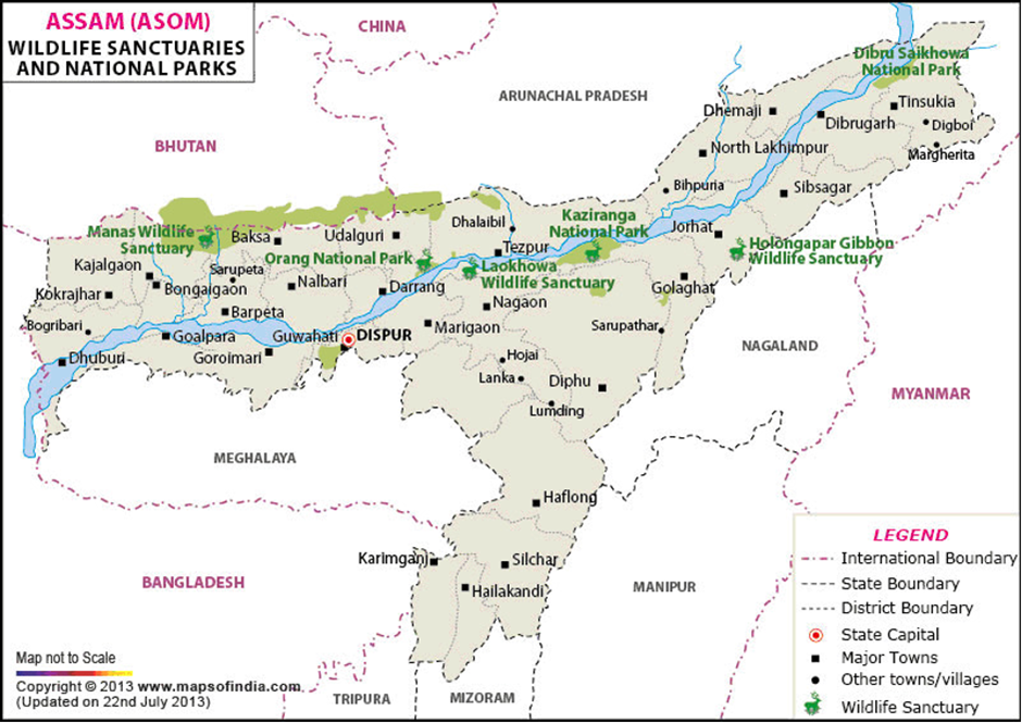
Dibru Saikhowa National Park
Why in news?
- The Environment Ministry's Forest Advisory Committee (FAC) approved an R&D proposal for Extended Reach Drilling (ERD) technology, strictly for research within Dibru Saikhowa National Park, ensuring it remains limited to scientific study without commercial exploitation.
About Dibru Saikhowa National Park:
-
Location:
- Dibru Saikhowa National Park, also designated as a Biosphere Reserve, is located in the extreme eastern part of Assam on the southern bank of the Brahmaputra River.
- It is bounded by the Brahmaputra and Lohit Rivers in the north and the Dibru River in the south.
- The park features a tropical monsoon climate, with hot and wet summers and cool, dry winters.
-
Flora and Fauna:
- The park primarily consists of moist mixed semi-evergreen forests and moist mixed deciduous forests. Notably, it is home to the largest Salix swamp forest in northeastern India.
- The dominant trees found here include Elephant Apple, Bishopwood, Silk Cotton Tree, and Crepe Myrtle. The rich vegetation supports a thriving ecosystem, making it a significant biodiversity hotspot.
- Dibru Saikhowa National Park harbours a diverse range of mammals, reptiles, amphibians, and birds.
- It is home to species such as the Royal Bengal Tiger, Asiatic Elephant, Leopard, Jungle Cat, Sloth Bear, Small Indian Civet, and Slow Loris.
- The park is also a critical habitat for the endangered Gangetic Dolphin, which lives in its riverine ecosystem.
-
Avian Diversity:
- Recognized as an Important Bird Area (IBA), the park hosts over 382 species of birds. Some of the significant bird species include the Greater Adjutant Stork, Lesser Adjutant Stork, and Greater Crested Grebe.
- The wetlands and forests of Dibru Saikhowa make it an ideal refuge for migratory and resident birds, further enhancing its ecological significance.
About Extended Reach Drilling (ERD) Technology
- Extended-reach drilling (ERD) is an advanced drilling technique used to extract resources from underground reservoirs located far from the drilling site.
- This technology enables operators to drill long horizontal wells with high precision, reducing the need for multiple drilling locations and minimising environmental impact.
Advantages of ERD technology:
- Minimises Surface Disturbance: By allowing extraction from a remote location, ERD reduces the need for new drilling sites, helping protect ecologically sensitive areas like national parks and biosphere reserves.
- Enhances Resource Recovery: ERD technology improves oil and gas recovery rates from reservoirs that might otherwise be inaccessible.
- Reduces Costs and Environmental Risks: By decreasing the number of well pads and associated infrastructure, ERD lowers land-use impact, deforestation, and habitat disruption.
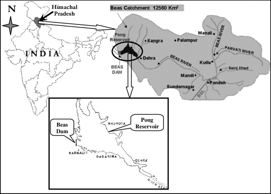
Pong Dam Lake Wildlife Sanctuary
Why in news?
- The 2025 annual bird count at Pong Dam Lake Wildlife Sanctuary reported a record increase in waterfowl populations, highlighting the site's ecological significance and its role as a crucial wintering habitat.
About Pong Dam Lake Wildlife Sanctuary:
-
Location:
- Pong Dam Lake Wildlife Sanctuary, also known as Maharana Pratap Sagar, is a manmade reservoir located in the wetland zone of the Shivalik hills in Kangra district, Himachal Pradesh.
- Formed by the construction of the Pong Dam on the Beas River, it spans an area of nearly 307 square kilometres, making it one of the largest man-made wetlands in Northern India.
- In 2002, it earned international recognition as a Ramsar site, emphasising its importance as a wetland of global ecological significance.
-
Flora and Fauna:
- The sanctuary boasts diverse vegetation, including submerged vegetation, grasslands, and forests. Key tree species found here are eucalyptus, acacia, and shisham (Indian rosewood).
- This mix of flora supports a variety of wildlife, providing both food and shelter. The grasslands and aquatic plants create a thriving environment for numerous species, while the forests contribute to the region’s ecological balance.
Owing to its strategic position along the trans-Himalayan flyway, the sanctuary is a paradise for birdwatchers. - It hosts over 220 bird species, including 54 species of waterfowl. Prominent among these are Bar-headed Geese, Pintails, Common Pochards, Coots, Grebes, Cormorants, Herons, and Storks.
- The sanctuary also shelters terrestrial birds like grey partridges, peafowl, and jungle fowl.
- In addition to its rich avifauna, Pong Dam Lake supports a variety of mammals, such as Sambar, Barking Deer, Wild Boar, Nilgai (Blue Bull), Clawless Otter, and Leopards. The presence of such a diverse range of animals highlights the sanctuary’s role in regional biodiversity conservation.
About Waterfowl:
- Waterfowl refer to aquatic birds that inhabit freshwater ecosystems, including ducks, geese, swans, coots, grebes, and cormorants. These birds rely on wetlands, lakes, and reservoirs for breeding, feeding, and migration.
- The increase in waterfowl population at Pong Dam Lake Wildlife Sanctuary is attributed to several factors:
-
- Improved Wetland Management: Conservation efforts and habitat restoration have enhanced the lake's ecological balance.
- Favourable Climatic Conditions: Mild winters and ample food availability have encouraged more migratory birds to settle.
- Reduced Human Disturbance: Controlled tourism and restricted activities have provided a safe refuge for birds.
- Increased Water Levels: Consistent water availability supports aquatic vegetation, boosting food resources for waterfowl.
-
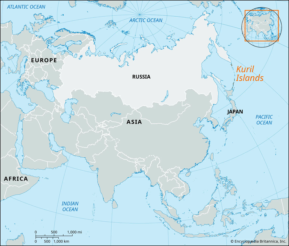
Kuril Islands
Why in news?
Japan’s Prime Minister reaffirmed commitment to resolving the Kuril Islands dispute with Russia, seeking a diplomatic solution to regain control over the territories occupied by Russia since World War II.
About Kuril Islands:
-
-
-
-
-
-
- Location:
- Location:
-
-
-
-
-
- The Kuril Islands are a chain of volcanic islands stretching from Hokkaido, Japan, to the Kamchatka Peninsula, Russia, separating the Sea of Okhotsk from the Pacific Ocean.
- The archipelago consists of 56 islands, divided into the Northern, Central, and Southern Kurils.
- The dispute between Japan and Russia centres on the four southernmost islands—Iturup (Etorofu), Kunashir (Kunashiri), Shikotan, and the Habomai Islets—which Japan refers to as its Northern Territories.
-
-
-
-
-
- Geopolitical Significance: The Kuril Islands hold strategic and economic importance for both Japan and Russia:
- Geopolitical Significance: The Kuril Islands hold strategic and economic importance for both Japan and Russia:
-
-
-
-
-
- Strategic Military Position: Control over the islands ensures dominance over the Sea of Okhotsk, a crucial maritime zone for Russia’s Pacific Fleet and nuclear submarines.
- Natural Resources: The region is rich in fisheries, oil, and natural gas reserves, making it economically significant.
- Trade and Security: Japan views the islands as integral to its territorial sovereignty, while Russia sees them as a key defence outpost in the Pacific region.
- Origin of the Bilateral Dispute:
- The Kuril Islands dispute began with the 1855 Treaty of Shimoda, granting Japan sovereignty over the four southernmost islands, while Russia retained the rest.
- Under the 1875 Treaty of Saint Petersburg, Japan ceded Sakhalin Island in exchange for full control of the Kuril chain.
- After Japan's victory in the 1905 Russo-Japanese War, it gained southern Sakhalin but lost it again in World War II.
- In 1945, the Soviet Union occupied the Southern Kurils, claiming them under the Yalta Agreement. The 1956 Japan-Soviet Joint Declaration proposed returning Shikotan and Habomai, but no peace treaty was ever finalised.
Other Territorial Disputes of Japan:
-
-
-
-
-
-
-
Senkaku Islands (China-Japan Dispute):
-
-
-
-
-
-
- The Senkaku Islands, located in the East China Sea, are uninhabited but hold significant geopolitical value due to their proximity to key shipping routes and potential oil and gas reserves.
- While Japan administers the islands, China and Taiwan both claim sovereignty, referring to them as Diaoyu and Diaoyutai, respectively.
- The dispute has intensified in recent years, with Chinese coast guard vessels frequently entering Japanese waters, leading to diplomatic tensions.
-
-
-
-
-
-
-
Takeshima/Dokdo Islands (Japan-South Korea Dispute):
-
-
-
-
-
-
- The Takeshima/Dokdo dispute involves a group of small islets in the Sea of Japan (East Sea), administered by South Korea but claimed by Japan.
- South Korea has stationed security personnel on the islands, reinforcing its control. The islets hold economic value due to rich fishing grounds, and the dispute has been a longstanding point of contention in Japan-South Korea relations.
- Despite Japan’s periodic assertions of sovereignty, South Korea maintains effective control and dismisses Japan’s claims.
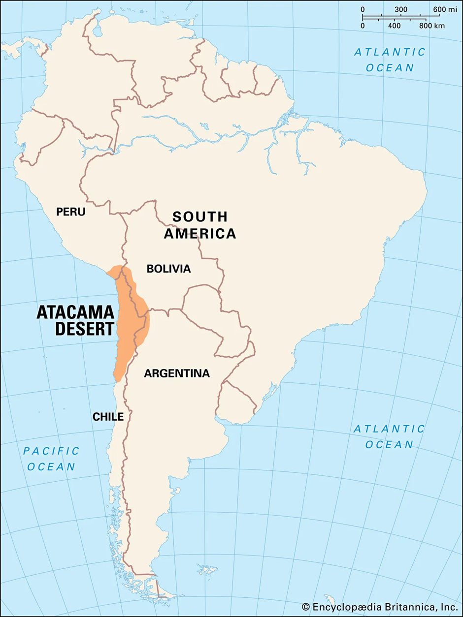
Atacama Desert
Why in news?
Astronomers have raised concerns about increasing light pollution threatening major global telescope sites, particularly in the Atacama Desert, Chile.
About Atacama Desert:
-
-
-
-
-
-
-
Location and Geography:
-
-
-
-
-
-
- The Atacama Desert is one of the driest places on Earth, spanning northern Chile along the Pacific coast of South America.
- It extends approximately 1,600 kilometres from southern Peru to northern Chile, covering an area of nearly 105,000 square kilometres.
- The desert is bordered by the Pacific Ocean to the west and the Andes Mountains to the east, creating a unique arid landscape characterised by vast salt flats, rocky plateaus, and volcanic terrain.
- The temperature in the Atacama Desert varies significantly, with daytime temperatures ranging from 25°C to 40°C, while nighttime temperatures can drop to -10°C in higher-altitude regions.
- This extreme diurnal temperature variation occurs due to the lack of atmospheric moisture, which prevents heat retention at night.
- The Atacama receives less than 15 mm of rainfall annually, with some areas recording zero rainfall for centuries.
- Certain regions, like the Antofagasta area, experience rainfall only once in several decades, making parts of the Atacama the driest non-polar desert on Earth.
-
-
-
-
-
-
Factors Leading to the Formation of the Atacama Desert:
-
-
-
-
-
-
- Rain Shadow Effect: The Andes Mountains act as a barrier to moisture-laden winds from the Amazon Basin, preventing rainfall from reaching the desert.
- Humboldt Current: This cold ocean current flows along the west coast of South America, cooling the air and reducing its ability to hold moisture, which suppresses cloud formation and rainfall.
- Subtropical High-Pressure System: The Hadley Cell circulation creates a high-pressure system over the region, leading to clear skies and extremely low humidity year-round.
- Coastal Influence: Despite its proximity to the ocean, the Atacama rarely receives precipitation because the cold air from the Humboldt Current discourages cloud formation. Instead, moisture arrives in the form of fog, which sustains a small but unique ecosystem.
-
-
-
-
-
-
Atacama Desert as a Telescopic Site for Astronomical Study:
-
-
-
-
-
-
- The Atacama Desert is considered one of the best locations on Earth for astronomical observations, thanks to its high elevation, minimal light pollution, dry climate, and stable atmospheric conditions.
- Some of the world’s most advanced observatories are located here, including:
- ALMA (Atacama Large Millimetre/submillimeter Array): A network of radio telescopes used for studying cosmic origins, galaxies, and exoplanets.
- Very Large Telescope (VLT): Operated by the European Southern Observatory (ESO), it provides deep-space imaging with unparalleled precision.
- Extremely Large Telescope (ELT) (Under Construction): Expected to be the world’s largest optical telescope, capable of exploring the early universe and exoplanet atmospheres.
|
UPSC CSE PYQs Q1. Which one of the following statements best reflects the issue with Senkaku Islands, sometimes mentioned in the news? (2022)
Answer: Option B |
|
Also Read |
|
| Public Administration Optional | |
| Question Answer Practice For UPSC | |

World's First 'Black Hole Bomb' Created in a Lab (2025)

From Democracy to Emocracy: Understanding the Shift

PLACES IN NEWS 5th MAY 2025
Karol Bagh Metro Pillar No. 112, Above Domino's, 22B, First Floor, New Delhi - 110060
Copyright © 2024-2026 ENSURE IAS. All rights reserved.