- Courses
- GS Full Course 1 Year
- GS Full Course 2 Year
- GS Full Course 3 Year
- GS Full Course Till Selection
- Online Program
- GS Recorded Course
- NCERT (Recorded 500+ Hours)
- Polity Recorded Course
- Geography Recorded Course
- Economy Recorded Course
- AMAC Recorded Course
- Modern India, Post Independence & World History
- Environment Recoded Course
- Governance Recoded Course
- Science & Tech. Recoded Course
- International Relations and Internal Security Recorded Course
- Disaster Management Module Course
- Ethics Recoded Course
- Essay Recoded Course
- Current Affairs Recoded Course
- CSAT
- 5 LAYERED ARJUNA Mentorship
- Public Administration Optional
- ABOUT US
- OUR TOPPERS
- TEST SERIES
- FREE STUDY MATERIAL
- VIDEOS
- CONTACT US
PLACES IN NEWS 6th MARCH 2025
PLACES IN NEWS 6th MARCH 2025

Mount Erebus
Why in news?
- Beneath Antarctica’s Mount Erebus, a hidden world of volcanic ice caves harbours thriving microbial life, offering a glimpse into how life could exist on alien worlds.
About Mount Erebus:
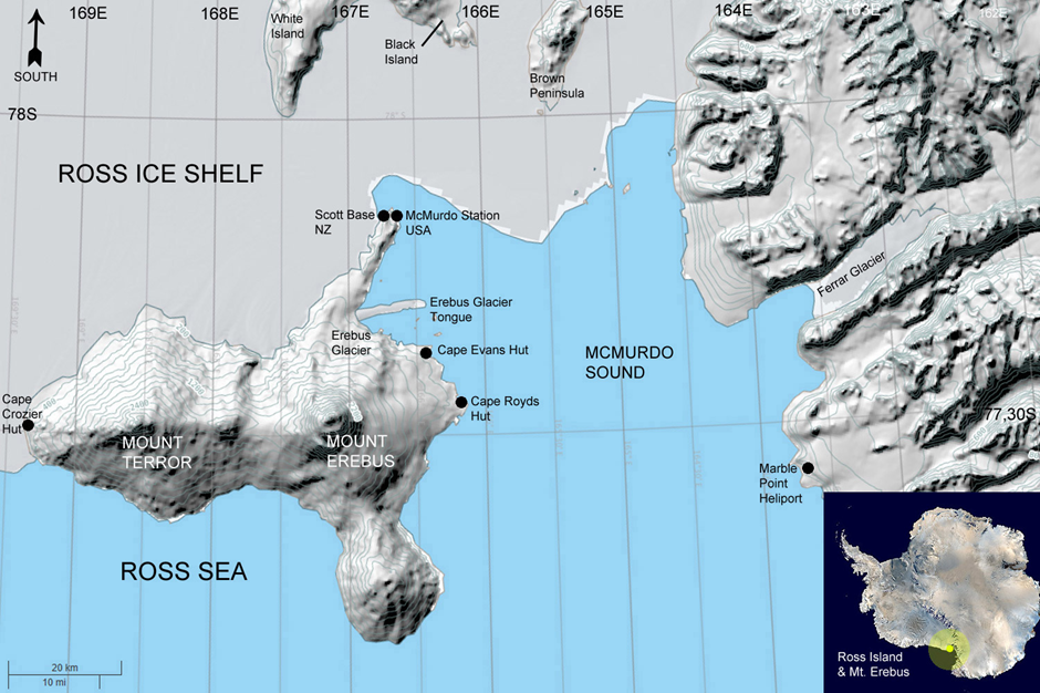
- Location:
- Mount Erebus is the southernmost active volcano in the world, located on Ross Island, Antarctica, near the Ross Sea.
- It is a glaciated intraplate stratovolcano and part of the Ring of Fire, a major volcanic belt encircling the Pacific Ocean basin.
- The volcano stands at 12,448 feet (3,794 meters), making it Antarctica’s second tallest volcano after Mount Sidley.
- It was discovered in 1841 by British explorer Sir James Clark Ross, who named it after his ship, the Erebus.
- Volcanic Activity:
- Mount Erebus has been continuously active since 1972, with Strombolian eruptions ejecting volcanic bombs onto its crater rim.
- It is one of the few volcanoes globally with an active lava lake, which contains alkalic lava, typically found in rift volcanoes.
- Beneath its surface, volcanic ice caves have formed due to geothermal heating.
- These caves harbour thriving microbial life, providing insights into possible extra-terrestrial life on icy moons and planets.
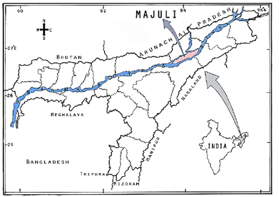
Majuli Island
Why in news?
- A six-day survey in Assam’s Majuli River Island district highlights growing concerns over escalating human-wildlife conflict (HWC), underscoring the urgent need for conservation and mitigation efforts.
About Majuli Island:
-
- Location:
- Location:
- Majuli Island is the world’s largest river island, situated in the Brahmaputra River in the state of Assam, India.
- It is formed by the Brahmaputra River in the south and the Kherkutia Xuti, an anabranch of the Brahmaputra, joined by the Subansiri River in the north.
- Spanning an area of 421 sq. km, it became the first island district in India in 2016.
- The island is known for its lush greenery, wetlands, and paddy fields, making it an ecologically significant region.
- Ecological Significance:
- Ecological Significance:
- Majuli is a biodiversity hotspot, home to diverse flora and fauna, including migratory birds, river dolphins, and wetland ecosystems.
- The island plays a crucial role in flood regulation and maintaining ecological balance within the Brahmaputra basin.
- Its rich wetlands provide an ideal habitat for numerous aquatic species, making it a significant site for conservation efforts.
- Due to its cultural and ecological value, Majuli has been included in India’s tentative list for UNESCO World Heritage sites.
- Human-Wildlife Conflict (HWC):
- Human-Wildlife Conflict (HWC):
- Deforestation, habitat loss, and climate change have led to increased human-wildlife conflict on the island.
- Encroachment on natural habitats due to agriculture and settlement expansion has forced wild animals, including elephants, to stray into human-inhabited areas.
- Frequent floods and riverbank erosion have further displaced wildlife, intensifying conflicts between humans and animals.
- Conservation efforts are needed to ensure sustainable coexistence between local communities and wildlife while preserving Majuli’s fragile ecosystem.
Wallace Line
Why in news?
- The Wallace Line is a biogeographical boundary separating Asian and Australasian species, highlighting evolutionary differences due to plate tectonics and isolation, shaping distinct ecosystems across Southeast Asia and Australia.
About Wallace Line:
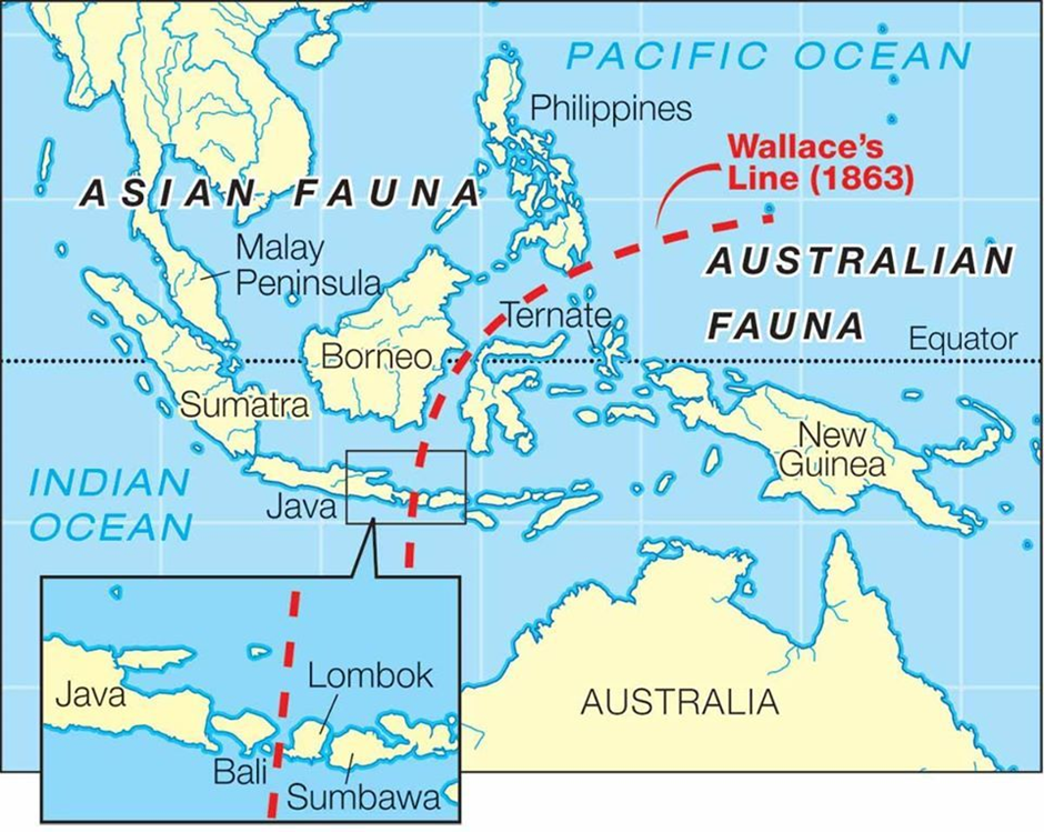
- Location:
- The Wallace Line is a biogeographical boundary that separates the fauna of Asia from the fauna of Australia in the Malay Archipelago.
- It runs between Bali and Lombok, extending northward between Borneo and Sulawesi, and then curves south of Mindanao in the Philippines.
- The line was first proposed by Alfred Russel Wallace, a 19th-century English naturalist, who noticed a stark difference in species distribution between these regions.
- This invisible divide plays a key role in modern biogeography, explaining why Asian species, like tigers and orangutans, are not naturally found in Australia, and why Australian species, like kangaroos and cockatoos, are absent from Asia.
- Species Differentiation Between the Regions:
- The Wallace Line marks a clear shift in biodiversity: to the west, the islands share species with mainland Asia, while to the east, species have strong Australian affinities.
- Islands like Borneo and Sumatra host Asian species such as tigers, elephants, and orangutans, while New Guinea and Australia contain marsupials like kangaroos and unique birds like cockatoos.
- Sulawesi, located near the Wallace Line, is particularly puzzling as it hosts a mix of both Asian and Australian species, including tarsiers (Asian origin) and cuscus (Australian origin).
- The lowland and mountain anoa, found only in Sulawesi, further highlight the complexity of species differentiation in the region.
- Reason Behind the Mystery:
- Wallace theorised that species distribution was influenced by ancient land connections. Some islands were once part of the Asian mainland, while others were connected to Australia, leading to separate evolutionary paths.
- Over millions of years, continental drift and plate tectonics played a crucial role. Australia broke away from Antarctica, moving towards Asia and forming the Indonesian archipelago.
- Differences in climate, sea levels, and monsoons influenced species migration. Warmer, wetter conditions in the Malay archipelago helped Asian species migrate south, while Australian species faced difficulty adapting to tropical environments.
- Recent studies analysing over 20,000 species of birds, mammals, reptiles, and amphibians confirm that geological and climatic history, rather than a single line, explains the unique distribution of species.
- Today, habitat destruction and climate change threaten the delicate balance of biodiversity in the Indo-Malayan region.
- Understanding these historical patterns is crucial for conservation efforts and predicting future species survival in response to environmental changes.
Torkham border
Why in news?
- Intense clashes between Pakistan and Afghanistan forces at the Torkham border have led to thousands fleeing the area, escalating tensions and disrupting trade and movement between the two neighbouring countries.
About Torkham border:
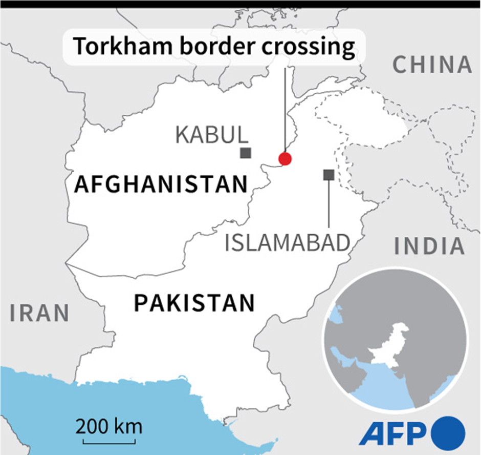
- Location:
- The Torkham border is a key crossing point between Pakistan and Afghanistan, situated in the Khyber Pass that connects Pakistan’s Khyber Pakhtunkhwa province with Afghanistan’s Nangarhar province.
- It serves as a crucial trade and transit hub, facilitating the movement of goods and people between the two countries.
- Background of Tensions:
- The recent clashes at Torkham reflect the ongoing tensions between Pakistan and Afghanistan, particularly under the Taliban regime.
- The immediate trigger for the latest confrontation was the dispute over an outpost constructed by Afghan forces near the border, leading to the closure of the crossing since February 21.
- This has disrupted trade, leaving 5,000 trucks stranded and causing economic losses of approximately $15 million.
- The conflict intensified on the first working day of Ramadan, when Afghan border guards allegedly fired without warning at Pakistani government buildings and civilians, causing widespread panic and forcing around 15,000 residents to flee.
- The Taliban authorities confirmed casualties, while Pakistani security forces also reported losses.
- Tensions at Torkham are not new, as Pakistan has accused Afghanistan of harbouring militants, while Afghanistan resents Pakistan’s border controls and security measures.
- The economic dependence of locals on cross-border trade further exacerbates the humanitarian impact of such clashes.
- The incident highlights the fragile state of Pakistan-Afghanistan relations, with no immediate resolution in sight.
Sambhar Lake
Why in news?
- The population of migratory birds at Rajasthan’s Sambhar Lake has increased 15-fold, indicating improved ecological conditions and conservation efforts in India’s largest inland saltwater lake, a key wintering site for avian species.
About Sambhar Lake:
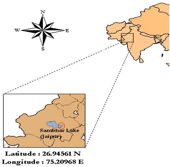
- Location:
- Sambhar Lake is India’s largest saltwater lake, situated in the Nagaur and Jaipur districts of Rajasthan.
- It is an elliptical-shaped saline wetland, stretching 35.5 km in length with a breadth varying from 3 km to 11 km.
- The lake spans over 200 sq. km and is surrounded by the Aravalli hills.
- It is primarily fed by ephemeral streams like Mendha and Runpangarh, along with surface runoff from surrounding areas.
- Key Features:
- Sambhar Lake is one of India’s most significant salt-producing regions, generating 210,000 tonnes of salt annually, making Rajasthan one of the top three salt-producing states.
- It was designated as a Ramsar site in 1990, recognising its ecological importance as a wetland of international significance.
- The lake plays a crucial role in supporting biodiversity, particularly for migratory birds.
- Ecological Significance:
- The wetland is one of the most important wintering areas for flamingos outside the Rann of Kachchh.
- Other migratory birds visiting the lake include pelicans, common shelduck, redshank, black-winged stilt, Kentish plover, Ruff, sociable lapwing, and common sandpiper.
- The lake’s diverse avian population makes it a crucial habitat for birdwatching and conservation efforts.
- Recent reports indicate a 15-fold increase in migratory bird populations, highlighting improved ecological conditions and the lake’s critical role in sustaining avian biodiversity.
|
UPSC CSE PYQs
Q1. Lake Sambhar is nearest to which one of the following cities of Rajasthan? (2004)
Answer: Option B |
|
Also Read |
|
| FREE NIOS Books | |


Donald Trump's 'One Big Beautiful Bill Act of 2025' (OBBBA)

Tyre Particles: How EVs are a climate solution with pollution problem

New Damselfly Species Discovered: Caliphaea Sinuofurcata
Karol Bagh Metro Pillar No. 112, Above Domino's, 22B, First Floor, New Delhi - 110060
Very Important Instruction For Any Issue, Student Must Produce His/Her Fee Receipt. Without Fee Receipt, It Will Not Be Possible To Track Your Details. If You Have Been Given Any Special Consideration, You Must Keep That In Writing And Produce In Case Of Conflict.
Copyright © 2024-2026 ENSURE IAS. All rights reserved.