- Courses
- GS Full Course 1 Year
- GS Full Course 2 Year
- GS Full Course 3 Year
- GS Full Course Till Selection
- MEP (Mains Enrichment Programme) Data, Facts
- Essay Target – 150+ Marks
- Online Program
- GS Recorded Course
- NCERT- First Ladder
- Polity
- Geography
- Economy
- Ancient, Medieval and Art & Culture AMAC
- Modern India, Post Independence & World History
- Environment
- Governance
- Science & Technology
- International Relations and Internal Security
- Disaster Management
- Ethics
- Current Affairs
- Indian Society and Social Issue
- CSAT
- 5 LAYERED ARJUNA Mentorship
- Public Administration Optional
- ABOUT US
- OUR TOPPERS
- TEST SERIES
- FREE STUDY MATERIAL
- VIDEOS
- CONTACT US
PLACES IN NEWS 4th MARCH 2025
PLACES IN NEWS 4th MARCH 2025
04-03-2025

Kawal Tiger Reserve
Why in news?
- In Kawal Tiger Reserve, solar pumps near borewells ensure efficient water supply to tanks, pits, and natural reservoirs, blending nature with technology.
About Kawal Tiger Reserve:
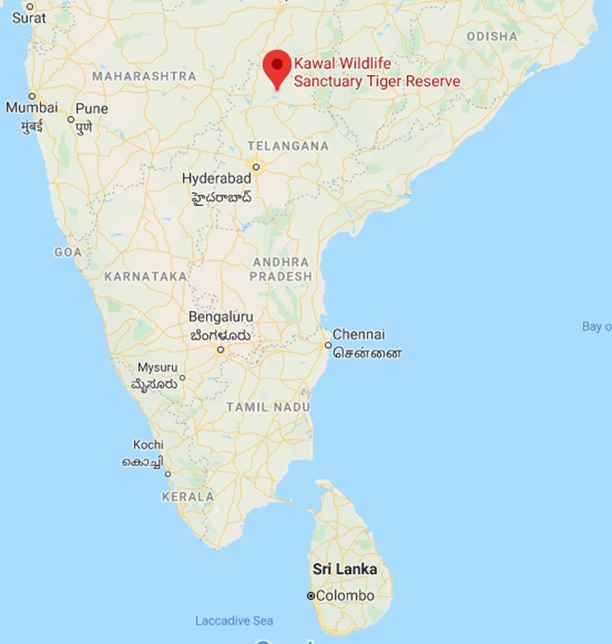
- Location and Geography:
- Kawal Tiger Reserve is located in Telangana, along the banks of the Godavari River.
- It is part of the Deccan Peninsula-Central Highlands and is nestled within the Sahyadri Mountain Ranges.
b. The reserve serves as a catchment area for the Godavari and Kadam Rivers, which flow south of the sanctuary, enriching its biodiversity. - Geographically, Kawal Tiger Reserve lies at the southernmost tip of the Central Indian Tiger Landscape, establishing vital ecological linkages with Tadoba-Andhari Tiger Reserve (Maharashtra) and Indravati Tiger Reserve (Chhattisgarh).
- The Government of India designated Kawal Wildlife Sanctuary as a Tiger Reserve in 2012 to strengthen conservation efforts.
- Flora and Fauna:
- The reserve predominantly features Southern Tropical Dry Deciduous Forests, providing a suitable habitat for diverse wildlife.
- The vegetation is rich, with teak as the dominant species, accompanied by bamboo and other trees like fig, arjuna, sal, mahua, and neem.
- The reserve is home to various herbivores, including nilgai, chowsingha, chinkara, blackbuck, sambar, spotted deer, and wild boar.
- Several carnivores, such as tigers, leopards, wild dogs, wolves, jackals, foxes, and jungle cats, thrive in the region.
- The varied landscape and abundant resources support a stable food chain, ensuring the conservation of keystone species like the tiger.
Rushikulya river
Why in news?
- To protect Olive Ridley turtle eggs, forest officials restricted entry along a 5-km stretch from Gokharakuda to Bateswar near the Rushikulya river mouth in Ganjam district.
About Rushikulya river:
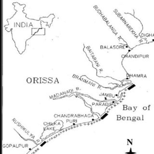
- Origin and Course:
- The Rushikulya River is a significant river in Odisha. It flows through the districts of Kandhamal, Ganjam, and Boudh.
- It originates from the Daringbadi Hills, which are located in the Eastern Ghats at an elevation of about 1000 meters. Because of their scenic beauty, these hills are often called the 'Kashmir of Odisha.'.
- The river travels approximately 165 kilometres before emptying into the Bay of Bengal near Ganjam town.
- Unlike many other rivers, it does not form a delta at its mouth, directly merging with the Bay of Bengal.
- The Rushikulya River basin covers an area of nearly 7,500 sq. km and has tributaries such as Baghua, Dhanei, and Badanadi.
- Ecological Significance and Mass Nesting of Olive Ridley Turtles:
- The Rushikulya River estuary is renowned for being one of the largest nesting sites for Olive Ridley Turtles in the world.
- The Rushikulya Beach, near the river’s mouth, witnesses an annual natural event called Arribada, where thousands of Olive Ridley Turtles arrive between January and March to lay their eggs.
- This mass nesting phenomenon plays a crucial role in the conservation of Olive Ridley Turtles, which are classified as vulnerable under the IUCN Red List.
- Conservation efforts, including restricted human access and beach protection measures, help safeguard these turtles during their nesting season.
- The Rushikulya nesting site, along with Gahirmatha and Devi River mouths, forms an essential part of India’s marine turtle conservation efforts.
White island
Why in news?
- New Zealand’s High Court recently overturned the conviction of White Island volcano owners for the 2019 eruption that killed 22 people.
About White island:
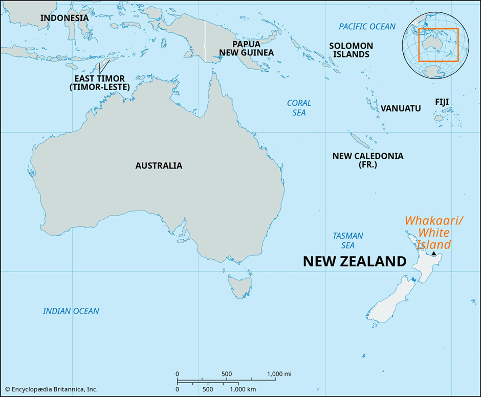
- Location and Geography:
- White Island (Whakaari) is an active composite stratovolcano situated in the Bay of Plenty, New Zealand.
- It lies 48 km off the coast of Whakatāne in the North Island and is considered New Zealand’s most active cone volcano.
- The volcano has been continuously active for over 150,000 years, with most of its mass submerged under the sea—only about 30% is visible above water.
- The island spans 325 hectares, with a diameter of two kilometres, and its highest point rises 321 meters above sea level.
- 2019 Volcanic Eruption:
- On December 9, 2019, White Island erupted unexpectedly, releasing toxic gases, ash, and steam while tourists and guides were present.
- The eruption resulted in 22 fatalities and severe burn injuries to multiple survivors, making it one of New Zealand’s deadliest volcanic disasters.
- Scientists had raised warnings about increased volcanic activity, but tours to the island continued.
- Legal Conviction and Overturning:
- The private owners of White Island faced legal charges for failing to ensure visitor safety despite known volcanic risks.
- In 2023, a court convicted them, but the New Zealand High Court recently overturned the conviction, citing insufficient legal grounds for their liability.
Guyana
Why in news?
- Guyana condemned a Venezuelan Navy incursion near an ExxonMobil oil facility, amid ongoing territorial disputes over the Essequibo region, escalating tensions between the two South American nations over resource rights.
About Guyana:
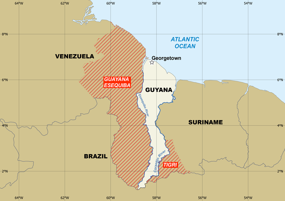
- Location and Geography:
- Guyana is a South American country, bordered by Venezuela to the west, Brazil to the south, Suriname to the east, and the Atlantic Ocean to the north.
- It covers an area of approximately 215,000 square kilometers, with vast rainforests, rivers, and savannahs forming its diverse landscape.
- The Essequibo River, the largest river in the country, flows through the disputed Essequibo region, which makes up nearly two-thirds of Guyana’s landmass.
- The coastal plains host most of the population and economic activities, while the interior regions remain rich in natural resources.
2. Resource Potential:
- Guyana is rich in natural resources, including bauxite, gold, diamonds, timber, and freshwater reserves.
- In recent years, massive offshore oil reserves have been discovered in the Stabroek Block, making Guyana one of the fastest-growing oil-producing nations.
- The ExxonMobil oil facility plays a crucial role in extracting and exporting crude oil, significantly boosting Guyana’s economic growth.
- The country’s oil industry is expected to transform its economy, attracting foreign investments and increasing geopolitical significance.
3. Territorial Dispute with Venezuela:
- Venezuela claims the Essequibo region, arguing that it was wrongfully awarded to Guyana under an 1899 arbitration ruling.
- The dispute escalated after Guyana discovered oil in offshore waters, prompting Venezuela to challenge Guyana’s control over the region.
- In December 2023, Venezuela held a referendum, rejecting international arbitration and asserting its claim over Essequibo, intensifying tensions.
- The recent Venezuelan Navy incursion near ExxonMobil’s oil facility heightened concerns about potential military confrontations and regional instability.
- Guyana has sought diplomatic support from international bodies like the United Nations and CARICOM, emphasizing peaceful resolution and adherence to international law.
Siliguri Corridor
Why in news?
- The Indian Army's Trishakti Corps, responsible for securing Sikkim and the Siliguri Corridor, conducted a month-long tank firing exercise to enhance combat readiness in the strategically vital northeastern region.
About Siliguri Corridor:
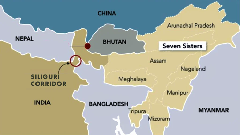
- Location and Geography:
- The Siliguri Corridor, also known as India’s Chicken’s Neck, is a narrow land strip located in West Bengal.
- It connects mainland India with the northeastern states and is approximately 60 km long and 22 km wide at its narrowest point.
- It borders Nepal to the west and Bangladesh to the south and is close to China (Tibet Autonomous Region) and Bhutan in the north.
- Strategic Importance:
- It serves as India’s only land link to the northeastern states, making it a critical lifeline for military, trade, and civilian movement.
- The corridor is crucial for troop deployment to border areas, especially in case of conflict with China in Arunachal Pradesh or Sikkim.
- The New Jalpaiguri railway station and Bagdogra airport play a vital role in logistical support and military mobilisation.
- Challenges in the Region:
- Geopolitical Threats: China’s increasing military presence in Tibet and infrastructure development along the border pose security risks.
- Bangladesh Border Security: Smuggling, illegal immigration, and cross-border crimes remain concerns.
- Terrain and Connectivity Issues: The corridor’s narrow geography makes it vulnerable to blockades, floods, and disruptions in times of crisis.
About Trishakti Corps:
- The Trishakti Corps is a key formation of the Indian Army, responsible for defending Sikkim and the Siliguri Corridor.
- It is part of the Eastern Command and plays a crucial role in monitoring border tensions with China and Bhutan.
- The corps conducts regular military exercises, including armoured warfare and high-altitude operations, to ensure combat readiness in this strategically sensitive region.
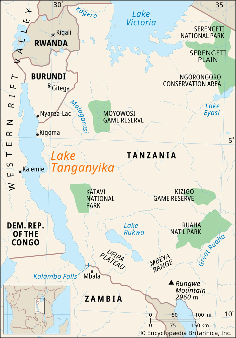
Lake Tanganyika
Why in news?
- Countries surrounding Lake Tanganyika—Burundi, DR Congo, Tanzania, and Zambia—launched a joint initiative to protect biodiversity, combat land degradation, and ensure sustainable management of Africa’s second-largest freshwater lake basin.
About Lake Tanganyika:
-
- Location and Geography:
- Location and Geography:
- Lake Tanganyika is one of Africa’s Great Lakes, located within the Albertine Rift, the western branch of the East African Rift Valley.
- It is bordered by Tanzania (46%), the Democratic Republic of the Congo (40%), Burundi, and Zambia.
- The lake stretches 676 km in length and has an average width of 50 km.
- It covers an area of 32,000 sq. km and has a shoreline of 1,900 km.
- Formation:
- Lake Tanganyika began forming 9–12 million years ago, making it one of the oldest lakes in the world.
- It was shaped by tectonic activity due to the movements of the African Plate and the Somali Plate, which created deep basins.
- The rifting process caused by the East African Rift System led to the gradual formation of the lake.
- The central basin formed first, followed by the northern and southern basins, as the rift valley continued to expand.
- Ecological Significance:
- Lake Tanganyika holds 16% of the world’s available freshwater and is Africa’s deepest lake, with a maximum depth of 1,471 meters.
- It is home to over 350 fish species, including endemic cichlids, supporting local fisheries.
- The lake’s biodiversity includes crocodiles, hippos, and water birds, making it an important ecosystem for both aquatic and terrestrial wildlife.
- The water is alkaline, with seasonal mixing occurring primarily in the southern part, allowing nutrient circulation essential for fish populations.
- Causes of Land Degradation:
- Deforestation: Unregulated tree cutting for agriculture and firewood has led to soil erosion, increasing sedimentation in the lake.
- Overfishing: Intensive fishing, including the use of illegal nets, has depleted fish stocks, affecting the lake’s ecosystem.
- Pollution: Industrial waste, untreated sewage, and agricultural runoff have led to water contamination.
- Climate Change: Rising temperatures have reduced oxygen levels in deeper waters, disrupting aquatic life.
- Mining Activities: Unregulated mining around the basin contributes to water pollution and habitat destruction.

Delays And Problems Are Hurting Ayushman Bharat In Jharkhand
CAG Conducts First Audit of Jal Jeevan Mission

RBI Cuts Repo Rates by 50 bps: Monetary Policy Move
Karol Bagh Metro Pillar No. 112, Above Domino's, 22B, First Floor, New Delhi - 110060
Very Important Instruction For Any Issue, Student Must Produce His/Her Fee Receipt. Without Fee Receipt, It Will Not Be Possible To Track Your Details. If You Have Been Given Any Special Consideration, You Must Keep That In Writing And Produce In Case Of Conflict.
Copyright © 2024-2026 ENSURE IAS. All rights reserved.