- Courses
- GS Full Course 1 Year
- GS Full Course 2 Year
- GS Full Course 3 Year
- GS Full Course Till Selection
- Online Program
- GS Recorded Course
- NCERT (Recorded 500+ Hours)
- Polity Recorded Course
- Geography Recorded Course
- Economy Recorded Course
- AMAC Recorded Course
- Modern India, Post Independence & World History
- Environment Recoded Course
- Governance Recoded Course
- Science & Tech. Recoded Course
- International Relations and Internal Security Recorded Course
- Disaster Management Module Course
- Ethics Recoded Course
- Essay Recoded Course
- Current Affairs Recoded Course
- CSAT
- 5 LAYERED ARJUNA Mentorship
- Public Administration Optional
- ABOUT US
- OUR TOPPERS
- TEST SERIES
- FREE STUDY MATERIAL
- VIDEOS
- CONTACT US
PLACES IN NEWS 4th APRIL 2025
PLACES IN NEWS 4th APRIL 2025

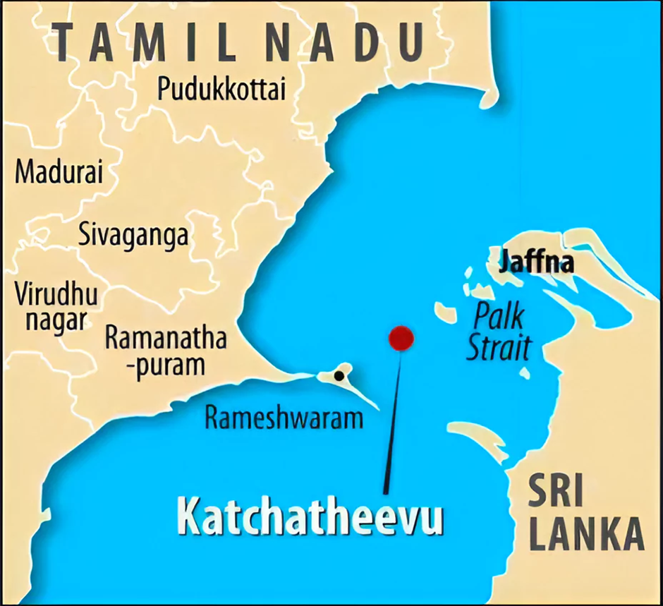
Katchatheevu Island
Why in news?
- The Tamil Nadu Assembly has unanimously passed a resolution once more, calling on the Union government to reclaim Katchatheevu Island from Sri Lanka.
About Katchatheevu Island:
- Location and Geography:
- Katchatheevu is a 285-acre uninhabited island located in the Palk Strait, lying between the southeastern coast of India and northern Sri Lanka.
- The island lies roughly 33 km northeast of Rameswaram in Tamil Nadu and 62 km southwest of Jaffna in Sri Lanka.
- The island was formed due to a volcanic eruption in the 14th century and serves as a geographical marker in the maritime boundary between the two nations.
- Though uninhabited, it is home to St Anthony’s Church, a revered religious site visited annually by fishermen and pilgrims from both countries.
- The surrounding waters are rich in marine resources, making it a vital area for fishing communities in Tamil Nadu.
- Historical and Political Background:
- Originally, the island was under the control of the Jaffna Kingdom of Sri Lanka, but it later came under the rule of the Ramnad Zamindars of Tamil Nadu during the Nayak dynasty.
- During the British colonial period, both British India and Ceylon (now Sri Lanka) claimed the island.
- In 1974, under the Indo-Sri Lankan Maritime Boundary Agreement, India officially recognised Sri Lanka’s sovereignty over Katchatheevu.
- The agreement also led to the drawing of the International Maritime Boundary Line (IMBL), based on the equidistance principle, aligning with the United Nations Convention on the Law of the Sea (UNCLOS).
- Tamil Nadu's Demand for Reclamation:
- Tamil Nadu has consistently demanded the retrieval of Katchatheevu, citing historical ties and the economic dependency of its fishermen on the area’s waters.
- Indian fishermen often face arrest by Sri Lankan authorities when they inadvertently cross into Sri Lankan waters while fishing near the island.
- The island's strategic location and access to fish-rich zones have made its reclamation a politically and economically significant issue in the state.
- Constitutional Process for Reclaiming Territory:
- As per Article 2 of the Indian Constitution, Parliament has the authority to admit or establish new states and alter the boundaries of existing ones.
- Reclaiming or modifying territory ceded to another country—like Katchatheevu, which was ceded to Sri Lanka in 1974—requires a bilateral agreement between the two nations. It may involve renegotiation of existing treaties or draughting a new treaty in accordance with international law.
- Once such an agreement is reached, parliamentary ratification is necessary through a constitutional amendment, as it affects India’s territorial sovereignty.
- A significant example is the India-Bangladesh Land Boundary Agreement (LBA) of 2015. Under this agreement, India and Bangladesh exchanged enclaves to resolve a decades-long border issue. This required the 100th Constitutional Amendment Act, 2015, which was passed by Parliament to give legal effect to the agreement.
Balpakram National Park
Why in news?
- Balpakram National Park in Meghalaya’s Garo Hills, a biodiversity hotspot, recently recorded the rare Binturong, captured via camera trap.
About Balpakram National Park:
- Location:
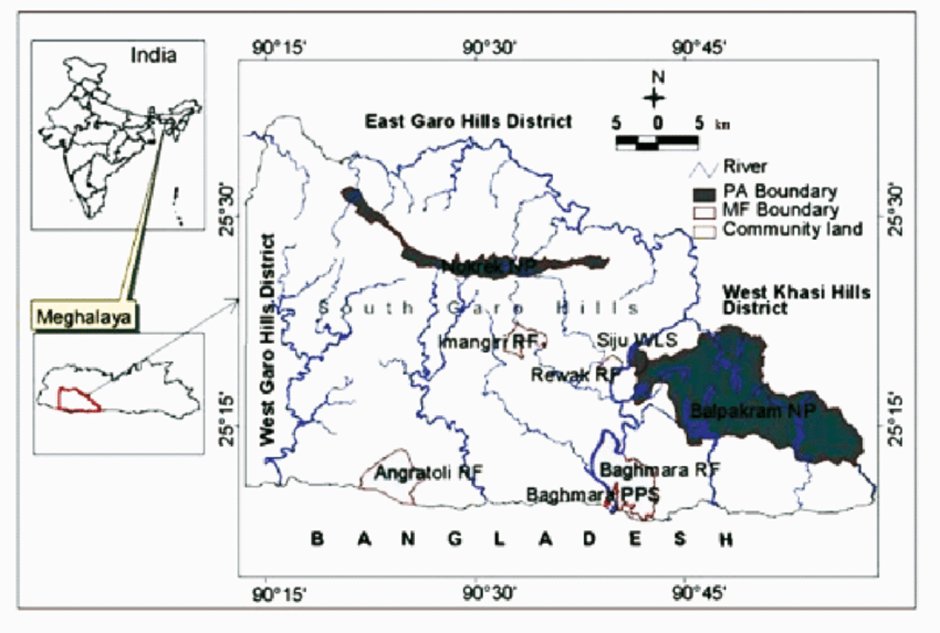
- Located in the West Garo Hills district of Meghalaya, about 134 km from Shillong, Balpakram National Park is a unique ecological haven nestled near the India-Bangladesh border.
- Perched at an altitude of nearly 3,000 feet (0.91 km), the park spans over 200 sq. km and is famed for its rugged terrain and strong winds—earning it the title of the "Land of Perpetual Winds".
- Declared a national park in 1987, Balpakram is culturally significant to the Garo tribe, who believe it to be the resting place of departed souls.
- One of its most striking features is a deep gorge, often compared to the Grand Canyon for its dramatic landscape and spiritual importance.
- Flora and Fauna:
- The park hosts a remarkable variety of flora, including rare and carnivorous plants like pitcher plants (Nepenthes khasiana), orchids, and Drosera.
- Its dense forest cover and varied terrain create ideal habitats for numerous endemic and endangered species.
- Among the fauna, elephants and tigers serve as flagship species. The park is also home to Hillock Gibbons, India’s only ape species, as well as deer, leopards, great Indian hornbills, wild buffalo, pheasants, and various species of wildcats and wild cows.
About the Binturong
- In a recent development, the elusive Binturong (Arctictis binturong)—commonly known as the bearcat—was captured on a camera trap by the Wildlife Trust of India’s Garo Green Spine project in Narang Wari Village Reserve Forest, located in the buffer zone of the park.
- The Binturong is the largest civet species in India and is typically found in the dense forests of Southeast Asia, including parts of India, Nepal, Bhutan, and Indonesia.
- Nocturnal and arboreal, it is known for its prehensile tail, shaggy black coat, and territorial scent glands.
- Conservation Status of Binturong:
- IUCN: Vulnerable
- Wildlife Protection Act, 1972: Schedule I
- CITES: Appendix III
Sagaing Fault
Why in news?
- The recent Myanmar earthquake was caused by strike-slip faulting along the Sagaing Fault between the Indian and Eurasian Plates.
About Sagaing Fault:
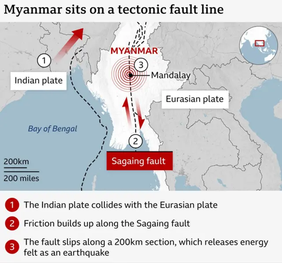
- The Sagaing Fault is a major transform fault running through Myanmar, extending over 1,200 km from north to south.
- It forms a tectonic boundary between the Indian Plate and the Eurasian Plate (specifically, the Sunda microplate).
- This strike-slip fault is highly active and has been the source of several significant earthquakes in the region.
- It passes near densely populated cities like Mandalay and Yangon, making it a zone of serious seismic risk.
- The fault accommodates the northward movement of the Indian Plate at a rate of about 18–25 mm per year, leading to frequent earthquake activity along its length.
Types of Faults
- Faults are breaks in the Earth’s crust where blocks of rock move due to the buildup and release of tectonic stress.
- When this stress surpasses the strength of the rock, it leads to a sudden slip along the fault, producing seismic waves—the cause of earthquakes.
- Faults are classified based on the direction of the relative movement between the blocks of rock:
- Normal Fault: In a normal fault, the hanging wall (the block above the fault plane) slips downward relative to the footwall. This occurs due to tensional forces that pull the crust apart. These faults are commonly seen at divergent plate boundaries where new crust is formed.
Examples: East African Rift Valley, Basin and Range Province (USA). - Reverse Fault: Here, the hanging wall moves upward relative to the footwall, caused by compressional forces that push the crust together. Reverse faults are typical of convergent boundaries, where tectonic plates collide and force rocks upwards, often creating mountain ranges.
Examples: the Himalayas, the Rocky Mountains. - Strike-Slip Fault: This fault involves horizontal movement of rock blocks with little to no vertical motion. The movement is lateral, and such faults are found at transform boundaries, where plates slide past each other.
Examples: Anatolian Fault (Turkey), Sagaing Fault (Myanmar). - Transform Fault: A transform fault is a specific type of strike-slip fault that marks the boundary between two tectonic plates. These faults can span vast distances and are capable of producing large earthquakes due to the immense stress between the sliding plates.
Example: San Andreas Fault (California, USA).
North Sentinel Island
Why in news?
- A U.S. citizen was recently detained in Andaman and Nicobar Islands for allegedly trespassing into North Sentinel Island's restricted tribal reserve.
About North Sentinel Island:

- A U.S. citizen was recently detained in Andaman and Nicobar Islands for allegedly trespassing into North Sentinel Island's restricted tribal reserve.
- About North Sentinel Island:
- North Sentinel Island is one of the remote Andaman Islands located in the Bay of Bengal and forms part of the Union Territory of Andaman and Nicobar Islands.
- Positioned to the west of the central Andaman cluster, the island spans approximately 60 square kilometres, measuring about 8 km in length and 7 km in width.
- Surrounded by a shallow coral reef and densely blanketed in tropical rainforest, the island remains untouched by modern development.
- The island is home to the Sentinelese, among the last uncontacted tribes in the world.
- Thought to be direct descendants of early humans who migrated out of Africa around 60,000 years ago, the Sentinelese have lived in voluntary isolation for millennia.
- They are known for fiercely resisting contact with the outside world, preserving their traditional lifestyle without external influence.
- To protect the tribe, the island is governed by the Andaman and Nicobar Protection of Aboriginal Tribes Act, 1956, which prohibits anyone from approaching closer than 5 nautical miles.
- Violating this law is a punishable offence under Indian legislation. Based on the 2011 census and anthropological estimates, the population ranges between 15 and 500 individuals.
|
Also Read |
|
UPSC Foundation Course |
|
| UPSC Monthly Magazine | CSAT Foundation Course |


Trump signs ‘Take it Down Act’ to combat deepfakes and online exploitation

A-to-I RNA Editing

Trade Restrictions against Bangladesh
Karol Bagh Metro Pillar No. 112, Above Domino's, 22B, First Floor, New Delhi - 110060
Very Important Instruction For Any Issue, Student Must Produce His/Her Fee Receipt. Without Fee Receipt, It Will Not Be Possible To Track Your Details. If You Have Been Given Any Special Consideration, You Must Keep That In Writing And Produce In Case Of Conflict.
Copyright © 2024-2026 ENSURE IAS. All rights reserved.