- Courses
- GS Full Course 1 Year
- GS Full Course 2 Year
- GS Full Course 3 Year
- GS Full Course Till Selection
- Online Program
- GS Recorded Course
- NCERT (Recorded 500+ Hours)
- Polity Recorded Course
- Geography Recorded Course
- Economy Recorded Course
- AMAC Recorded Course
- Modern India, Post Independence & World History
- Environment Recoded Course
- Governance Recoded Course
- Science & Tech. Recoded Course
- International Relations and Internal Security Recorded Course
- Disaster Management Module Course
- Ethics Recoded Course
- Essay Recoded Course
- Current Affairs Recoded Course
- CSAT
- 5 LAYERED ARJUNA Mentorship
- Public Administration Optional
- ABOUT US
- OUR TOPPERS
- TEST SERIES
- FREE STUDY MATERIAL
- VIDEOS
- CONTACT US
PLACES IN NEWS 2nd APRIL 2025
PLACES IN NEWS 2nd APRIL 2025
02-04-2025

Gandhi Sagar Wildlife Sanctuary
Why in news?
- Gandhi Sagar Wildlife Sanctuary in Mandsaur, Madhya Pradesh, is preparing to host cheetahs under India's ongoing cheetah reintroduction program.
About Gandhi Sagar Wildlife Sanctuary:
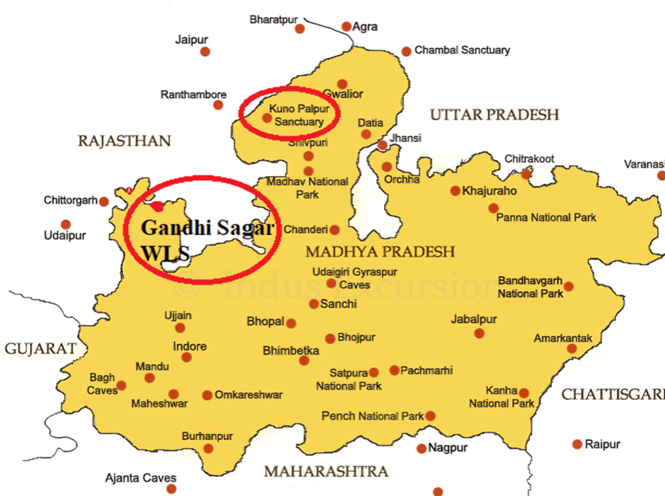
- Location:
- Gandhi Sagar Wildlife Sanctuary (GSWS) is situated on the northern boundary of the Mandsaur and Neemuch districts in Madhya Pradesh, India.
- It spans an area of 368.62 km² (142.32 sq mi) and shares a border with Rajasthan.
- The Chambal River flows through the sanctuary, dividing it into two parts: the western part in Neemuch district and the eastern part in Mandsaur district.
- The sanctuary lies within the Khathiar-Gir dry deciduous forests ecoregion, featuring diverse landscapes of wooded hills and grasslands.
- Flora and Fauna:
- The sanctuary’s vegetation consists mainly of dry, mixed deciduous forests and flat grasslands near the Gandhi Sagar Dam submergence area.
- Major tree species include Khair (Acacia catechu), Salai, Kardhai, Dhawda, Tendu, and Palash.
- The primary wildlife species found in GSWS include:
- Deer species: Chinkara (Indian gazelle), nilgai, and sambar.
- Carnivores: Indian leopard and Indian wild dog.
- Other fauna: langur, peacock, otter, and mugger crocodile.
Bannerghatta National Park
Why in news?
- Bannerghatta National Park intensifies wildlife protection efforts by launching an anti-snare drive to prevent poaching and safeguard its biodiversity.
About Bannerghatta National Park:
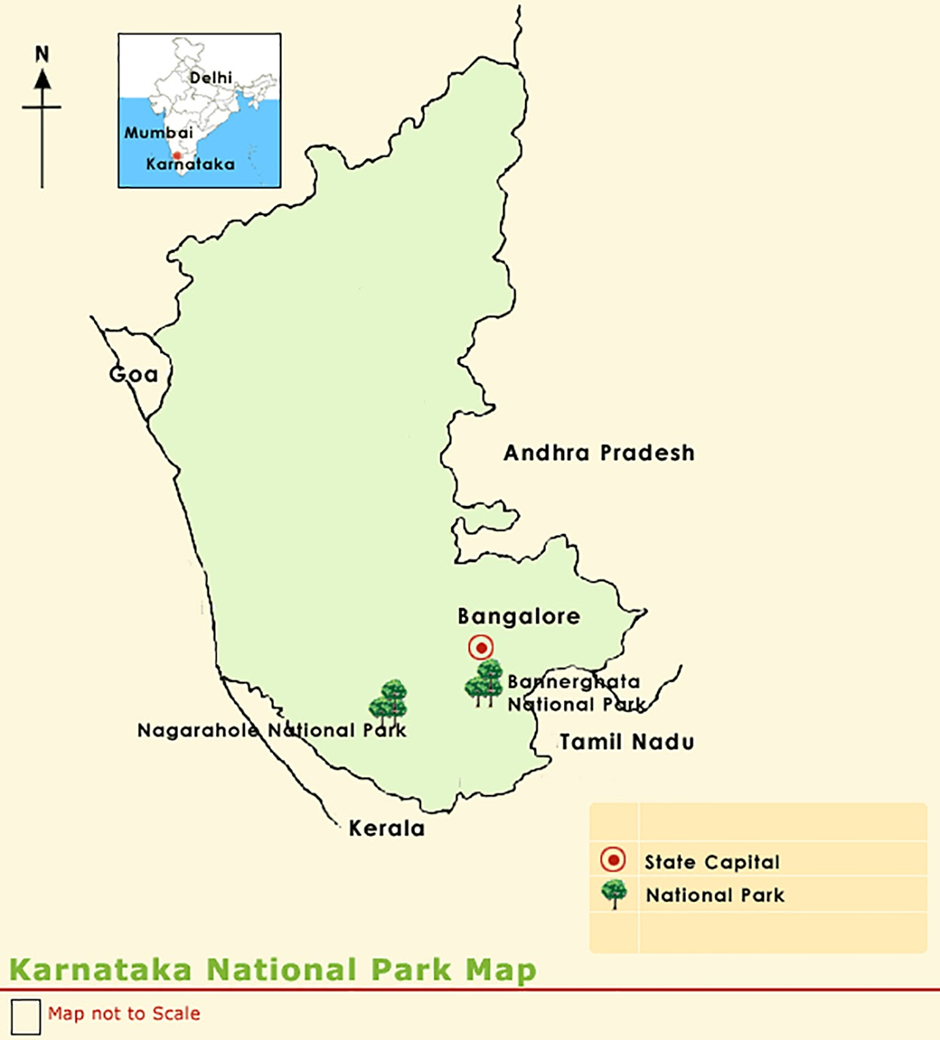
- Location:
- Bannerghatta National Park (BNP) is located in the Bengaluru and Ramanagara districts of Karnataka, India.
- It was established in 1970 and declared a national park in 1974. A part of the park was converted into the Bannerghatta Biological Park in 2002.
- The park covers an area of 260.51 km² and lies in the Anekal range at an elevation of 1,245–1,634 meters.
- BNP is part of an elephant corridor connecting Biligiriranga Hills (BR Hills) and Sathyamangalam Forest, ensuring the movement of large mammals.
- The Suvarnamukhi stream flows through the park, and additional bore wells have been installed to ensure water availability.
- Flora and Fauna:
- The park features moist deciduous forests, scrublands, and artificial forests.
Major tree species include sandalwood, neem, tamarind, bamboo, and eucalyptus. - Fauna in BNP includes:
- Large mammals: Indian elephants, leopards, gaurs, sloth bears, jackals, and wild boars.
- Deer species: spotted deer, barking deer, and Indian gazelle (chinkara).
- Carnivores: Royal Bengal tiger, Indian wolf, striped hyena, and Asiatic lion.
- Reptiles: monitor lizards, cobras, pythons, Russell’s viper, and kraits.
- Birds: Flamingos, pelicans, peacocks, and over 101 recorded bird species.
- Anti-Snare Drive:
- Bannerghatta National Park has launched an anti-snare drive to prevent poaching and illegal wildlife trapping.
- The initiative aims to remove snares and traps set by poachers that endanger animals, particularly tigers, leopards, and elephants.
- Forest officials, NGOs, and local communities are involved in conducting surveillance and dismantling snares.
- The drive is crucial for protecting Bannerghatta’s wildlife, as illegal hunting and habitat destruction pose significant threats.
- It is part of a broader effort to enhance conservation measures, reduce human-wildlife conflicts, and ensure the safety of animals in the park.
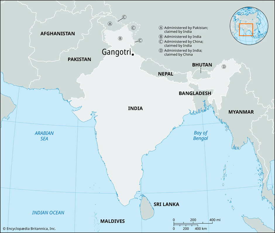
Gangotri National Park
Why in news?
- Gangotri National Park, Uttarakhand, reopens for tourists, offering access to its diverse flora, fauna, and scenic Himalayan landscapes.
About Gangotri National Park:
-
- Location and Geography:
- Gangotri National Park (GNP) is located in the Uttarkashi district of Uttarakhand, India. It was established in 1989 and covers an area of 2,390 km² (920 sq mi).
- The park lies in the upper catchment of the Bhagirathi River and shares its north-eastern boundary with China.
- It falls under the West Himalayan biogeographical zone and features high-altitude landscapes, including glaciers, deep gorges, and steep ridges.
- The Gaumukh Glacier, the origin of the Ganges River, is located within the park. The Gangotri temple, one of Hinduism’s holiest shrines, is also situated nearby.
- The park serves as a crucial ecological corridor, connecting Govind National Park and Kedarnath Wildlife Sanctuary.
- Elevation ranges from 1,800 m to 7,083 m, resulting in diverse ecosystems from subtropical forests to alpine meadows.
- Flora and Fauna:
- The park has Western Himalayan subalpine conifer forests at lower elevations and alpine meadows at higher altitudes.
- Major tree species include deodar, fir, spruce, oak, chir pine, and rhododendrons.
- Gangotri National Park is home to the snow leopard, a top predator of the region.
- Other key mammal species include the Asian black bear, brown bear, musk deer, blue sheep, and Himalayan tahr.
- Over 150 bird species are recorded, including the Himalayan monal, koklass pheasant, snowcock, partridges, and doves.
- The diverse landscape supports a rich biodiversity, making it an important conservation area in the Indian Himalayas.
East Khasi Hills
Why in news?
- BSF apprehended five Bangladeshi infiltrators in East Khasi Hills, Meghalaya, for illegal border crossing.
About East Khasi Hills:
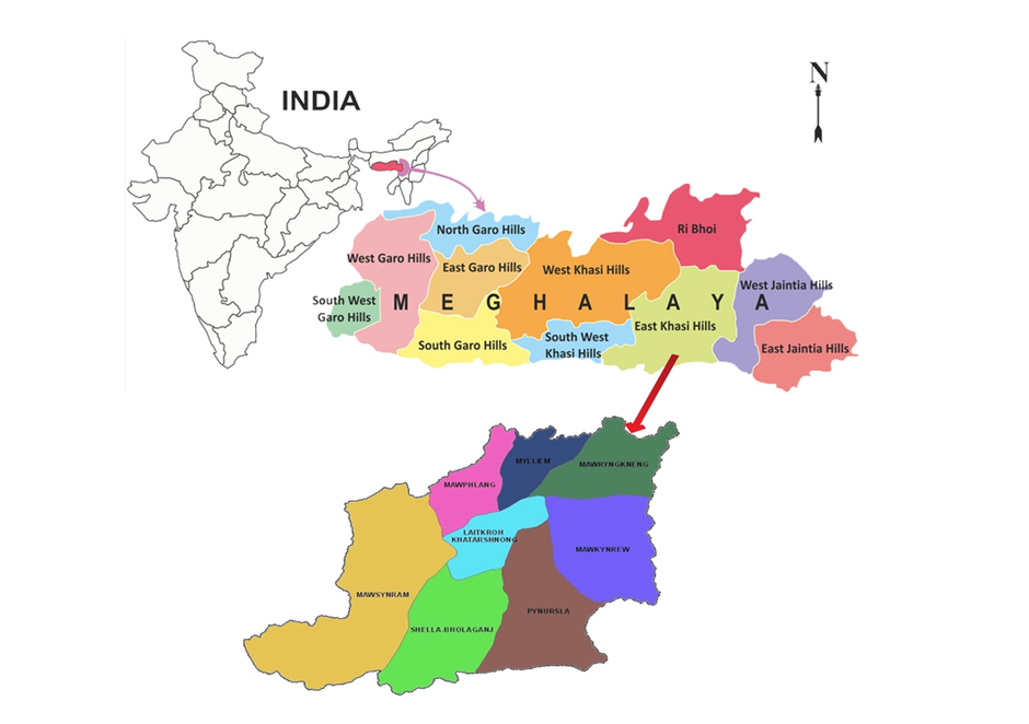
- Location and Geography:
- East Khasi Hills is a district in the state of Meghalaya, India, with Shillong as its headquarters.
- It shares an international border with Bangladesh to the south and is surrounded by West Khasi Hills, Ri-Bhoi, and South West Khasi Hills.
- The district features rugged terrain, deep gorges, waterfalls, and rolling hills, forming part of the Shillong Plateau.
- The Wah Umngot and Umiam rivers are major water bodies, with the Umiam Lake serving as a key hydroelectric source.
- The region experiences high rainfall, misty weather, and cool temperatures, influenced by the Southwest Monsoon.
- Natural Resources:
- East Khasi Hills is rich in limestone, coal, granite, and uranium deposits, making mining a key economic activity.
- The region has extensive forests with medicinal plants, orchids, and bamboo species, supporting the local economy.
- Agriculture and horticulture thrive in the district, with products like betel nut, oranges, pineapples, and ginger.
- Hydropower potential is significant, with projects like Umiam Hydroelectric Plant contributing to energy production.
- Issues of Illegal Migration:
- Due to its porous border with Bangladesh, East Khasi Hills faces persistent issues of illegal migration.
- Infiltrators from Bangladesh enter for livelihood opportunities, land encroachment, and illegal trade.
- The rise in demographic changes, pressure on resources, and potential security threats have led to local discontent.
- Human trafficking, drug smuggling, and cross-border crimes are linked to unregulated migration in the region.
- Government Initiatives to Combat Illegal Migration:
- Border Security Force (BSF) patrols the India-Bangladesh border to prevent illegal crossings.
- The Indo-Bangladesh Border Fence (IBBF) is being constructed to enhance border security.
- Advanced surveillance technologies like drones, night vision cameras, and motion sensors are deployed for monitoring.
- The Meghalaya Residents Safety and Security Act (MRSSA) was enacted to regulate the entry of outsiders and prevent illegal settlements.
- Identification and deportation drives are conducted in coordination with the Bangladesh government.
- The Integrated Check Posts (ICPs) and border outposts are being strengthened to curb unauthorised movements.
Nankai Trough
Why in news?
-
-
- Japan's latest report warns of a potential megaquake and tsunami along the Nankai Trough, potentially causing 298,000 fatalities.
-
About Nankai Trough:
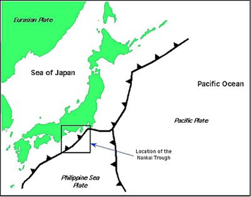
- Location & Geography
- The Nankai Trough is a 900 km (559 mi) long submarine trench located south of Honshu, Japan.
- It extends from Shizuoka Prefecture to the southern tip of Kyushu in the Nankaidō region.
- It is a subduction zone, where the Philippine Sea Plate is moving beneath the Eurasian Plate.
- The region is part of the Pacific Ring of Fire, one of the world’s most tectonically active areas.
- Tectonic Activity & Megaquakes
- The Nankai Megathrust Fault is the main cause of Nankai Trough earthquakes, which occur every 100–200 years.
- The last major earthquake in the region occurred in 1946.
- A megaquake (magnitude 8 or higher) along this fault could trigger a tsunami and cause widespread destruction.
- The Japanese government estimates a 75-82% chance of a megaquake within the next 30 years.
- Megaquake & Tsunami Risk
- A new government report warns that a megaquake and tsunami along the Nankai Trough could cause 298,000 deaths and $2 trillion in damages.
- The 2011 Tōhoku earthquake (magnitude 9.0) was a similar megathrust event that caused a tsunami and the Fukushima nuclear disaster.
- Japan’s first megaquake advisory was issued in August 2023 due to a magnitude 7.1 earthquake.
- What is a megaquake?
- A megaquake is an earthquake with a magnitude of 8.0 or higher.
- It occurs at subduction zones, where one tectonic plate is forced beneath another.
- Megaquakes are capable of causing tsunamis due to the sudden movement of the seafloor.
- Natural Resources & Economic Impact
- The Nankai Trough contains methane clathrate deposits, a potential hydrocarbon fuel source.
- A megaquake in the region would severely impact Japan’s economy, infrastructure, and coastal cities.
- Government Measures & Preparedness
- Strict earthquake-resistant building codes are in place across Japan.
- Early warning systems and evacuation plans are continuously updated.
- Seawalls and tsunami barriers have been reinforced after the 2011 disaster.
- Public awareness campaigns encourage disaster preparedness and emergency supply stocking.
|
Also Read |
|
| NCERT Books For UPSC | |
| UPSC Monthly Magazine | Best IAS Coaching in Delhi |


World's First 'Black Hole Bomb' Created in a Lab (2025)

From Democracy to Emocracy: Understanding the Shift

PLACES IN NEWS 5th MAY 2025
Karol Bagh Metro Pillar No. 112, Above Domino's, 22B, First Floor, New Delhi - 110060
Copyright © 2024-2026 ENSURE IAS. All rights reserved.