- Courses
- GS Full Course 1 Year
- GS Full Course 2 Year
- GS Full Course 3 Year
- GS Full Course Till Selection
- Answer Alpha: Mains 2025 Mentorship
- MEP (Mains Enrichment Programme) Data, Facts
- Essay Target – 150+ Marks
- Online Program
- GS Recorded Course
- Polity
- Geography
- Economy
- Ancient, Medieval and Art & Culture AMAC
- Modern India, Post Independence & World History
- Environment
- Governance
- Science & Technology
- International Relations and Internal Security
- Disaster Management
- Ethics
- NCERT Current Affairs
- Indian Society and Social Issue
- NCERT- Science and Technology
- NCERT - Geography
- NCERT - Ancient History
- NCERT- World History
- NCERT Modern History
- CSAT
- 5 LAYERED ARJUNA Mentorship
- Public Administration Optional
- ABOUT US
- OUR TOPPERS
- TEST SERIES
- FREE STUDY MATERIAL
- VIDEOS
- CONTACT US
PLACES IN NEWS 28th June 2025
PLACES IN NEWS 28th June 2025
28-06-2025

1. Khandwa, Madhya Pradesh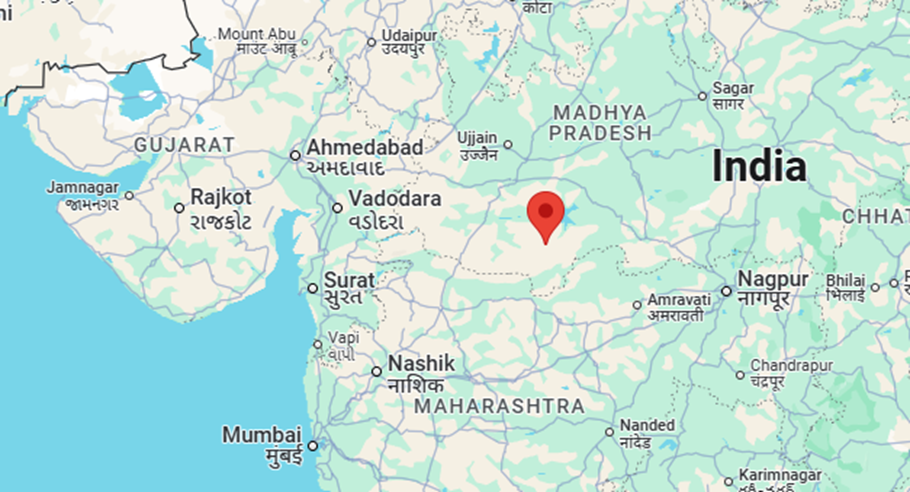
Why in the News?
- Khandwa district has been ranked first in India for its exemplary water conservation efforts under the “Jal Sanrakshan Bhagirath” campaign by the Ministry of Jal Shakti.
- Overall, Madhya Pradesh has been ranked 4th among all states.
- This recognition highlights the district’s success in mobilizing public participation and leveraging multiple funding sources for sustainable water management.
Key Highlights about Khandwa:
- Location: Situated in southwestern Madhya Pradesh, part of the Nimar region.
- Funding Sources: MGNREGA, 15th and 5th Finance Commission, CSR initiatives and public participation.
- Water Conservation structures: Well Recharge Pits, Recharge Shafts, Dugwells, Boulder Check Dams, Boulder Walls, Rooftop Rainwater Harvesting Systems, etc.
- Ghoda Pachhad River, a tributary of Narmada:
- With the support of local citizens and administration, this river has been revived.
- Using the ridge to valley system, water has been harvested over a 33 km stretch.
- This has enabled a possibility for the river to flow year-round.
- Topography Overview:
- Khandwa's terrain is largely defined by the uplands nestled between the Narmada and Tapti river valleys.
- These rivers run roughly parallel east to west, shaping the district’s natural drainage and elevation contours.
- Hatti Hill Range: Prominent in the southern part of the district, it borders and overlooks the Tapti Valley, culminating in the district's highest point — Pipardol Peak (917.5 m).
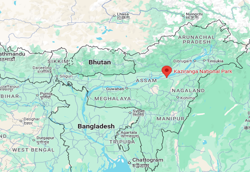
2. Kaziranga National Park
Why in the News?
- The Dhole, also known as the Asiatic wild dog (Cuon alpinus), was once thought to have disappeared from the Kaziranga-Karbi Anglong Landscape (KKAL) in Assam.
- Scientists from the Wildlife Institute of India (WII) have confirmed that the animal has returned to this area, according to a new study.
- Dholes need large forest areas that are peaceful and not disturbed by humans.
- Their presence in this area proves that the corridor is still healthy for wildlife.
- So, it is important to protect and conserve this forest corridor.
About Kaziranga National Park:
- Location and Area
- Situated in the state of Assam.
- Spreads over 42,996 hectares.
- Legal and Conservation Status
- Declared a National Park in 1974.
- Became a Tiger Reserve in 2006.
- International Recognition
- Declared a UNESCO World Heritage Site in 1985.
- Recognized as an Important Bird Area by BirdLife International.
- Key Wildlife Species
- Famous for the largest population of one-horned rhinoceroses.
- Pobitora Wildlife Sanctuary has the second highest rhino density after Kaziranga.
- Conservation focus is on the "Big Four":
- One-horned Rhinoceros
- Asian Elephant
- Royal Bengal Tiger
- Asiatic Water Buffalo
- 2018 census:
- 2,413 rhinos
- Around 1,100 elephants
- 2014 tiger census:
- Estimated 103 tigers
- 3rd highest tiger population in India (after Jim Corbett and Bandipur National Park)
- Hosts 9 out of 14 species of primates found in the Indian subcontinent.
- Famous for the largest population of one-horned rhinoceroses.
- Rivers and Transport
- National Highway 37 passes through the park.
- Over 250 seasonal water bodies are present.
- The Diphlu River flows through the park.
- Other National Parks in Assam
- Dibru-Saikhowa National Park
- Manas National Park
- Nameri National Park
- Rajiv Gandhi Orang National Park


India Climbs SDG Ranks

China's New Trilateral Moves in South Asia

Semaglutide and Tirzepatide
Karol Bagh Metro Pillar No. 112, Above Domino's, 22B, First Floor, New Delhi - 110060
Very Important Instruction For Any Issue, Student Must Produce His/Her Fee Receipt. Without Fee Receipt, It Will Not Be Possible To Track Your Details. If You Have Been Given Any Special Consideration, You Must Keep That In Writing And Produce In Case Of Conflict.
Copyright © 2024-2026 ENSURE IAS. All rights reserved.