- Courses
- GS Full Course 1 Year
- GS Full Course 2 Year
- GS Full Course 3 Year
- GS Full Course Till Selection
- Online Program
- GS Recorded Course
- NCERT (Recorded 500+ Hours)
- Polity Recorded Course
- Geography Recorded Course
- Economy Recorded Course
- AMAC Recorded Course
- Modern India, Post Independence & World History
- Environment Recoded Course
- Governance Recoded Course
- Science & Tech. Recoded Course
- International Relations and Internal Security Recorded Course
- Disaster Management Module Course
- Ethics Recoded Course
- Essay Recoded Course
- Current Affairs Recoded Course
- CSAT
- 5 LAYERED ARJUNA Mentorship
- Public Administration Optional
- ABOUT US
- OUR TOPPERS
- TEST SERIES
- FREE STUDY MATERIAL
- VIDEOS
- CONTACT US
PLACES IN NEWS 25th FEBRUARY 2025
PLACES IN NEWS 25th FEBRUARY 2025

Lake Ontario
Why in news?
- Climate change threatens Lake Ontario by altering water levels, temperatures, and ecosystems. Lessons from the Little Ice Age highlight the need for adaptive strategies to mitigate environmental and socio-economic impacts.
About Lake Ontario:
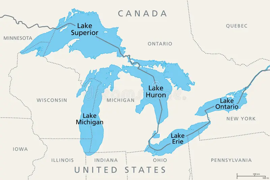
- Location:
- Lake Ontario is the easternmost of the five Great Lakes of North America. It is situated between the Canadian province of Ontario and the U.S. state of New York.
- It is the smallest of the Great Lakes by surface area but plays a crucial role in the region’s hydrology, acting as the outlet of the Great Lakes system into the St. Lawrence River.
- Key water bodies connected to Lake Ontario include the Niagara River (which feeds into it from Lake Erie), the St. Lawrence River (which drains it towards the Atlantic Ocean), and various tributaries such as the Genesee, Oswego, and Trent Rivers.
2. Ecological and Economic Significance:
- Lake Ontario supports a diverse ecosystem, providing habitat for numerous aquatic species, including fish like salmon, trout, and bass. Its wetlands and shoreline forests support various birds and mammals.
- The lake is vital for regional economies, contributing to fisheries, tourism, and transportation. The Great Lakes-St. Lawrence Seaway facilitates trade, with ports handling goods like grain, minerals, and manufactured products.
- Urban centres like Toronto and Rochester rely on Lake Ontario for drinking water, industrial activities, and recreational opportunities, including boating, fishing, and water sports.
- Impact of Climate Change on Lake Ontario:
- Rising temperatures alter the lake’s thermal structure, potentially disrupting fish populations and the broader aquatic food web. Warmer waters may also promote the spread of harmful algal blooms.
- Climate change is contributing to extreme fluctuations in lake levels. Higher water levels have led to shoreline erosion, threatening infrastructure such as homes, septic systems, nuclear power plants, and fuel refineries.
- Increased pollution and nutrient runoff from agriculture and urbanisation further stress the lake’s ecosystem, leading to declining water quality and loss of biodiversity.
- More frequent and intense storms are exacerbating water contamination and increasing sediment loads, affecting aquatic habitats.
- Lessons from the Little Ice Age:
- The Little Ice Age (14th–19th century) saw a cooling climate that forced Indigenous and settler societies around Lake Ontario to adapt their resource and food acquisition strategies.
- Indigenous groups such as the Haudenosaunee and Anishinaabeg adjusted their agricultural methods, relying on diverse crops resilient to changing conditions.
- The cooler climate increased demand for furs in Europe, driving the North American fur trade, which reshaped political and economic systems in the region.
- Heavier ice cover on Lake Ontario enabled more reliable winter transportation, with settlers using skates, sleighs, and iceboats for trade and movement.
- Resilience and Future Adaptation:
- While Lake Ontario has historically demonstrated resilience, modern climate challenges are pushing it to its limits. To mitigate further environmental degradation, immediate action is needed.
- Strategies must include reducing carbon emissions, improving wastewater management, and restoring natural shorelines to combat erosion and protect biodiversity.
- Just as previous generations adapted to climatic shifts, modern societies must embrace sustainable practices, balancing economic growth with ecological preservation to ensure Lake Ontario’s future viability.
Honduras
Why in news?
-
- India sends 26 tons of humanitarian aid to Honduras to support recovery efforts after the devastation caused by Tropical Storm SARA.
About Honduras:
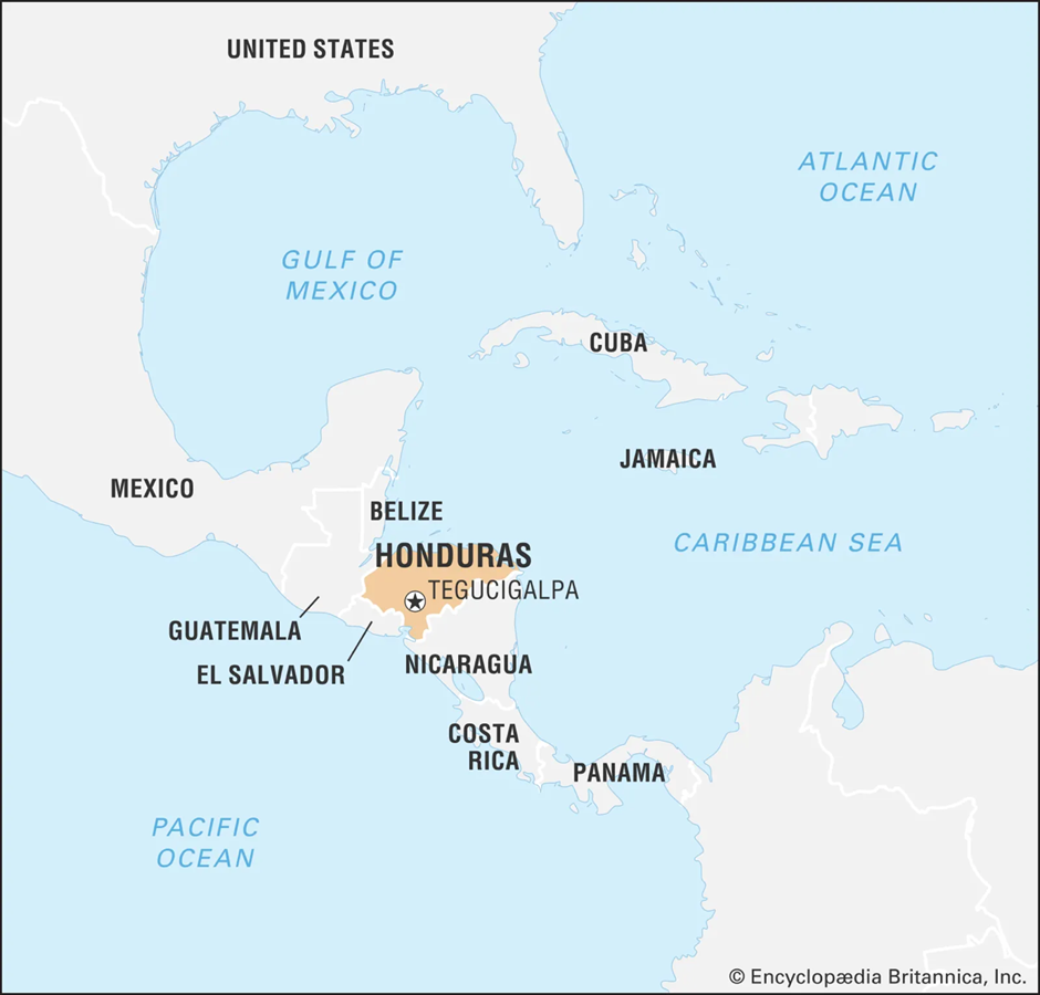
- Location and Geography:
- Honduras is a country in Central America, bordered by Guatemala to the northwest, El Salvador to the southwest, and Nicaragua to the southeast. It has coastlines along both the Caribbean Sea to the north and the Pacific Ocean to the south.
- The capital city of Honduras is Tegucigalpa, serving as the country’s political and economic hub.
- Over 75% of Honduras is mountainous, which limits arable land. The Sula Valley in the northwest is a highly fertile and densely populated region, while La Mosquitia in the northeast hosts the Río Plátano Biosphere Reserve, a UNESCO World Heritage Site.
- Major rivers include the Coco River, which forms part of the border with Nicaragua.
- Natural Resources and Economy:
- Honduras has a rich base of natural resources, including forests, minerals, and fertile lands.
- The country’s key exports include coffee, tropical fruits, sugarcane, textiles, and minerals, making agriculture a vital part of its economy.
- Formation of Tropical Storm SARA and its Impact:
- Tropical Storm SARA originated in the Atlantic Ocean, forming off the coast of Honduras due to warm ocean temperatures and favourable atmospheric conditions.
- As the storm intensified, it moved toward the Nicaraguan-Honduran border, gaining strength from the moist tropical air.
- SARA made landfall near the Nicaraguan-Honduran border, bringing heavy rainfall, strong winds, and storm surges.
- It triggered catastrophic flooding and landslides, displacing thousands and causing extensive damage to infrastructure, homes, and farmlands across Honduras and neighbouring countries.
- The storm also disrupted agriculture, impacting crop yields and leading to economic losses.
Zagros Mountains
Why in news?
-
- A geologist recently stated that a hilly region surrounding Iraq's Zagros Mountains is gradually sinking into the Earth.
About Zagros Mountains:
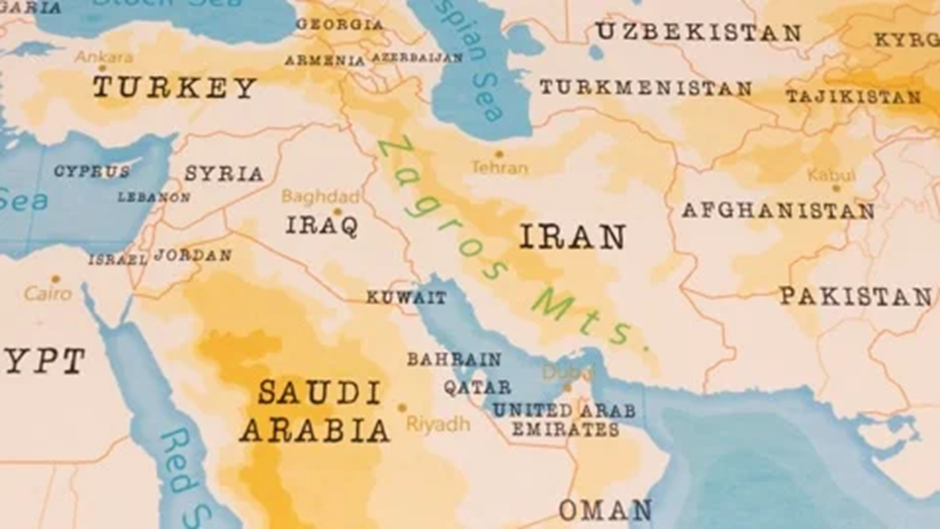
1. Location and Geography:
- The Zagros Mountains form a major mountain range in Central Asia, extending approximately 1,500 kilometres in a northwest-to-southeast direction.
- They stretch from the border areas between eastern Turkey and northern Iraq, across the Iranian Plateau, and extend to the Strait of Hormuz in southern Iran.
- The highest peak in the Zagros Mountain system is Mount Dena, which rises to an elevation of 14,465 feet (4,409 meters).
2. Type and Formation:
- The Zagros Mountains are fold mountains, formed due to tectonic activity over millions of years.
- Scientists estimate that these mountains were created through orogenic episodes triggered by the collision of the Arabian Plate with the Eurasian Plate.
- This process began during the Miocene Epoch (23 to 5.3 million years ago) and the Pliocene Epoch (5.3 to 2.6 million years ago), leading to the uplifting of rock layers and the formation of the Zagros Mountain range.
3. Geological Composition and Climate:
- The Zagros Mountains primarily consist of limestone and shale rocks.
- The region experiences a semi-arid temperate climate, with severely cold winters and highly arid summers.
- Vegetation includes temperate broad-leaved forests, dominated by oak and pistachio trees, along with dense steppe vegetation covering the ground.
4. Historical and Cultural Significance:
- The Zagros Mountains have historically served as a natural barrier, shaping the boundaries of ancient and modern empires.
- They separated major civilisations, including the Mesopotamian, Median, Parthian, and Roman cultures.
- The ancient city of Susa, one of the world's oldest urban centres, is located in the Zagros region.
5. Reason Behind Shrinking:
- Recent studies suggest that some hilly areas surrounding the Zagros Mountains in Iraq are being pulled into the Earth due to tectonic forces and subsidence.
- The ongoing compression between the Arabian and Eurasian plates is causing gradual crustal deformation, leading to the sinking of certain regions.
- Additionally, erosion and groundwater depletion contribute to the land subsidence, further altering the landscape of the Zagros Mountains.
Mula River
Why in news?
- Residents are protesting against Pimpri-Chinchwad Municipal Corporation plan to cut and transplant trees for the Mula River project, citing environmental concerns and advocating for sustainable development while preserving the region’s green cover.
About Mula River:
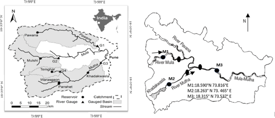
-
- The Mula River originates in the Western Ghats of Maharashtra, India. It emerges from the Mulshi Dam region, which is located in Pune district.
- It flows eastward through the Pune Metropolitan Region, passing through major areas such as Hinjawadi, Aundh, Baner, and Pimpri-Chinchwad.
- It eventually merges with the Mutha River near Sangamwadi in Pune.
- The combined flow of the Mula-Mutha River later joins the Bhima River, a tributary of the Krishna River.
- The main tributary of the Mula River is the Pavana River, which originates from the Sahyadri Hills and flows through Pimpri-Chinchwad before merging with Mula.
- The Mula-Mutha River system is crucial for Pune’s water supply, agriculture, and biodiversity.
Pocharam Wildlife Sanctuary
Why in news?
- The Telangana Wildlife Board has granted approval for road widening within Pocharam Wildlife Sanctuary, raising concerns about its potential impact on the sanctuary's ecosystem and biodiversity.
About Pocharam Wildlife Sanctuary:
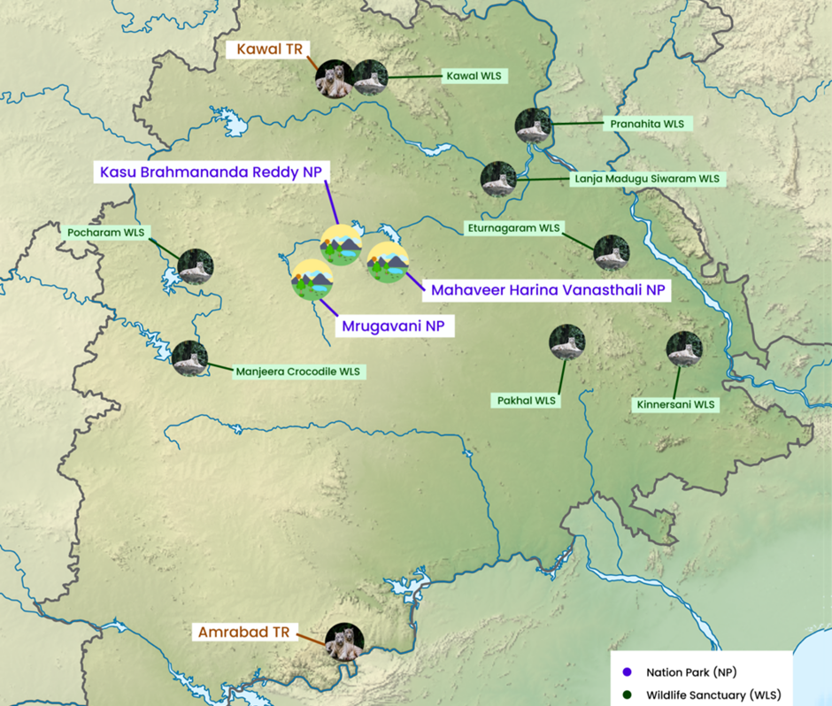
1. Location:
- Pocharam Wildlife Sanctuary is located in Telangana, India, spanning the districts of Medak and Nizamabad.
- The sanctuary is named after the Pocharam Lake, which was formed by the Pocharam Dam on the Allair River, a tributary of the Manjira River.
- It covers an area of approximately 130 square kilometres and serves as a crucial habitat for various wildlife species.
2. Flora:
- The sanctuary features dry deciduous forests mixed with scrub vegetation, typical of the Deccan Plateau.
- Dominant tree species include teak, sandalwood, neem, and tamarind.
- The Pocharam Lake supports aquatic vegetation, providing an important habitat for wetland species.
- The sanctuary is home to mammals like leopards, sloth bears, wild boars, nilgai, and sambar deer.
- Bird species include pelicans, painted storks, cormorants, and herons, making it a significant bird-watching site.
- Reptiles such as crocodiles, monitor lizards, and various snake species also inhabit the region.
|
Also Read |
|
| FREE NIOS Books | |

World’s First Baby Treated with Personalized CRISPR Gene Editing

China’s 1st Attempt To Survey And Sample an Asteroid : China’s Space Mission Tianwen-2

India Assumes Chairmanship of Asian Productivity Organisation (APO) – 2025-26
Karol Bagh Metro Pillar No. 112, Above Domino's, 22B, First Floor, New Delhi - 110060
Very Important Instruction For Any Issue, Student Must Produce His/Her Fee Receipt. Without Fee Receipt, It Will Not Be Possible To Track Your Details. If You Have Been Given Any Special Consideration, You Must Keep That In Writing And Produce In Case Of Conflict.
Copyright © 2024-2026 ENSURE IAS. All rights reserved.