- Courses
- GS Full Course 1 Year
- GS Full Course 2 Year
- GS Full Course 3 Year
- GS Full Course Till Selection
- Online Program
- GS Recorded Course
- NCERT (Recorded 500+ Hours)
- Polity Recorded Course
- Geography Recorded Course
- Economy Recorded Course
- AMAC Recorded Course
- Modern India, Post Independence & World History
- Environment Recoded Course
- Governance Recoded Course
- Science & Tech. Recoded Course
- International Relations and Internal Security Recorded Course
- Disaster Management Module Course
- Ethics Recoded Course
- Essay Recoded Course
- Current Affairs Recoded Course
- CSAT
- 5 LAYERED ARJUNA Mentorship
- Public Administration Optional
- ABOUT US
- OUR TOPPERS
- TEST SERIES
- FREE STUDY MATERIAL
- VIDEOS
- CONTACT US
PLACES IN NEWS 24th MARCH 2025
PLACES IN NEWS 24th MARCH 2025

Gambhiri River
Why in news?
- Rajasthan High Court seeks response on alleged encroachment in Gambhiri river floodplain, impacting water supply to Ghana Bird Sanctuary, Bharatpur.
About Gambhiri River:
- Gambhir River, also known as the Utangan River, is a significant seasonal river in Rajasthan.
- The river originates in the Aravalli Hills near Hindaun and flows through multiple districts before reaching Uttar Pradesh.
- It primarily flows during the rainy season, making it an ephemeral river for most of the year.
- After confluence with the Parbati River (outside Dholpur District), it becomes perennial.
- It follows a south-to-north course and ultimately merges with the Yamuna River.
- The Gambhir River Basin lies in northeastern Rajasthan, bordered by the Banganga River Basin (north), Banas River Basin (southwest), and Chambal & Parbati Rivers (southeast), with Uttar Pradesh forming its northeastern boundary.
- It supplies water to the Keoladeo National Park, a UNESCO World Heritage Site.
- Total Length: Approximately 288 km.
- Major tributaries: Sesa, Kher, and Parbati Rivers.
Hemavati River
Why in news?
- Two youths recently drowned while swimming in the Hemavati River near Henli village in Sakleshpur.
About Hemavati River:
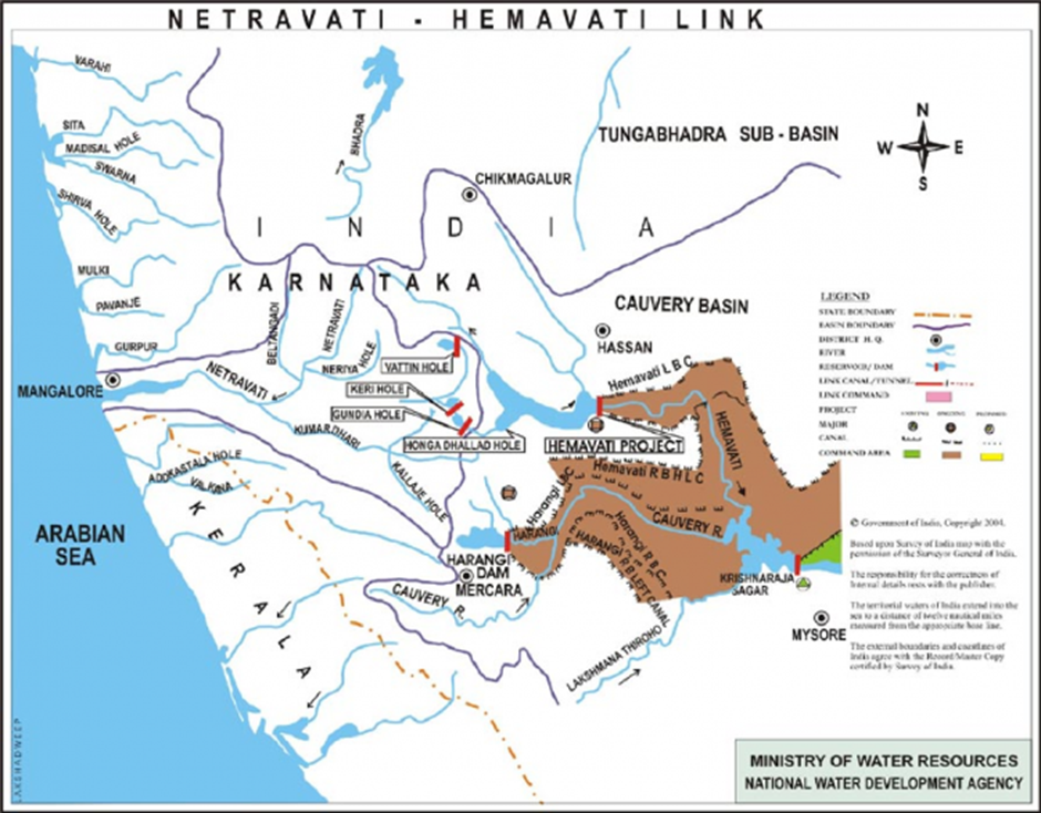
- The Hemavati River originates in the Western Ghats at Javali village, situated at an elevation of 1,230 metres (4,040 ft), located in Mudigere taluk of Chikmagalur District, Karnataka.
- It flows through Mudigere taluk (Chikmagalur District), Hassan District, and Mandya District before merging with the Kaveri River near Krishnarajasagara.
- The river spans approximately 245 km and drains an area of about 5,410 km².
- • The Yagachi River is its chief tributary, joining it in Hassan District.
- The Hemavati Dam (Gorur Dam) was completed in 1979 in Hassan District, downstream from the Yagachi confluence.
- The dam has a live storage capacity of 35.7 TMC and provides irrigation and drinking water to Hassan, Mandya, and Tumkur districts.
- The Shettihalli Rosary Church, built in the 1860s, was submerged due to the dam's construction and is visible only when water levels are low.
Israel-Syria
Why in news?
- Israel conducted airstrikes on two military bases in central Syria, targeting strategic locations.
About Israel-Syria:
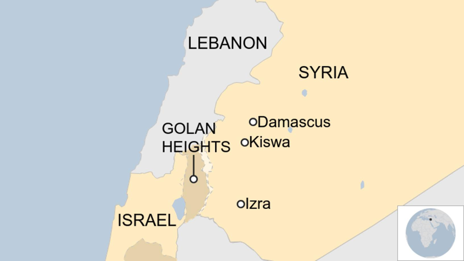
- Historical Context
- The Israel-Syria conflict dates back to the 1948 Arab-Israeli War, when Syria opposed Israel’s creation.
- The two nations fought multiple wars, including the Six-Day War (1967), after which Israel captured the Golan Heights from Syria.
- The Yom Kippur War (1973) saw Syria attempting to reclaim lost territory but was unsuccessful.
- Since then, Syria has supported groups like Hezbollah, while Israel has conducted military operations to counter Syrian threats.
- Recent Reasons for Airstrikes
- Israeli airstrikes on Palmyra and T4 military bases aim to prevent arms from reaching groups hostile to Israel.
- Since December, following the fall of Bashar al-Assad’s regime, Israel has targeted Syrian military sites to limit the new authorities’ capabilities.
- Israeli Prime Minister Benjamin Netanyahu has demanded the demilitarisation of southern Syria, particularly regions south of Damascus.
- Israel also claims to protect the Druze minority, citing recent sectarian tensions in Damascus.
- Syria accuses Israel of destabilising the region through repeated military interventions.
- Conflict Regions in News
- Palmyra & T4 Airbase: Sites of recent Israeli airstrikes targeting strategic military locations.
- Southern Syria & Damascus: Regions where Israel seeks to prevent hostile forces' presence.
- Golan Heights: A long-standing disputed territory between Israel and Syria.
- Druze Communities in Damascus: Israel claims to intervene to protect this minority from sectarian clashes.
Bhadra Wildlife Sanctuary
Why in news?
- The Karnataka Forest Department will ‘soft release’ captured elephants into Bhadra Sanctuary to reduce human-elephant conflict in Hassan, Chikkamagaluru, and Kodagu.
About Bhadra Wildlife Sanctuary:
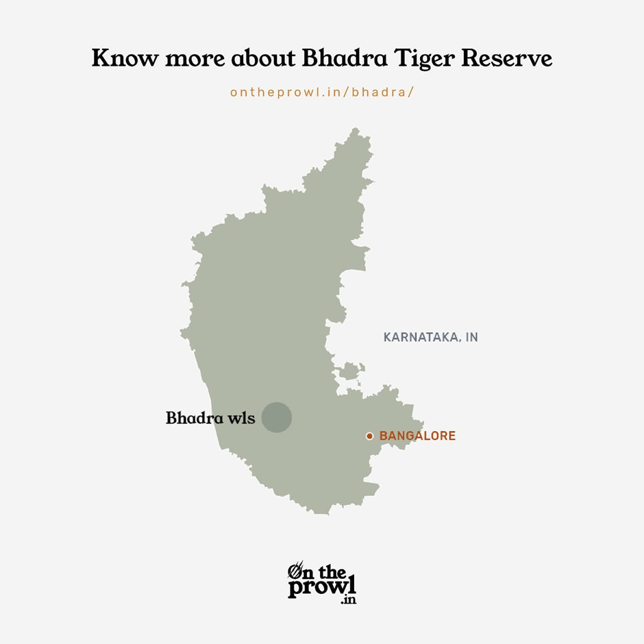
- Location and Geography:
- Bhadra Wildlife Sanctuary, a Project Tiger reserve, is located in Chikkamagaluru district, Karnataka, 23 km south of Bhadravathi and 283 km from Bengaluru.
- The sanctuary covers an area with elevations ranging from 615 m to 1,875 m, with Hebbe Giri as the highest peak.
- It is surrounded by the Mullayanagiri, Hebbegiri, Gangegiri, and Bababudangiri hills, forming part of the Western Ghats.
- The Bhadra River, along with its tributaries, flows through the sanctuary, and the Bhadra Reservoir forms its western boundary.
- The region experiences a temperature range of 10°C to 35°C, with annual rainfall varying between 1,200 mm and 2,600 mm.
- Flora and Fauna:
- The sanctuary is a biodiversity hotspot, consisting of wet deciduous, moist deciduous, and evergreen forests, along with shola forests and grasslands.
- Over 120 plant species are found, including teak, rosewood, Indian laurel, fig trees, bamboo, and several medicinal plants.
- It is home to 33 tigers, along with elephants, leopards, gaurs, sloth bears, wild boars, sambar deer, and langurs.
- Rare species like the black leopard, Malabar giant squirrel, flying squirrel, and pangolin also inhabit the area.
- Small carnivores, including leopard cats, otters, and mongooses, contribute to the sanctuary’s rich ecosystem.
- Reason Behind Human-Animal Conflict:
- Encroachment and deforestation near the sanctuary have reduced wildlife habitats, leading to animals straying into human settlements.
- Elephants, leopards, and wild boars frequently raid crops, damaging agriculture and causing financial losses to local farmers.
- Occasional tiger and leopard attacks on livestock increase tensions between wildlife conservationists and villagers.
- Villages near the sanctuary, like Jagara and Sirivase, face frequent human-wildlife interactions due to their proximity to the forest.
- Steps Taken to Prevent Human-Animal Conflict:
- Relocation of villages: Bhadra was the first tiger reserve in India to complete a successful village relocation programme in 2002, moving 26 villages to safer locations.
- Elephant management: Captured elephants are being soft-released into the sanctuary to minimise conflicts in Hassan, Chikkamagaluru, and Kodagu.
- Compensation schemes: Farmers affected by wildlife damage receive financial aid from the Karnataka Forest Department.
- Eco-development initiatives: Awareness programmes educate locals on coexisting with wildlife and conservation efforts.
- Fencing and barriers: Solar-powered fences and elephant-proof trenches have been set up to protect farmlands.
Atacama Desert
Why in news?
- Increasing light pollution in Chile’s Atacama Desert threatens the visibility and efficiency of its world-class astronomical telescopes and observatories.
About Atacama Desert:
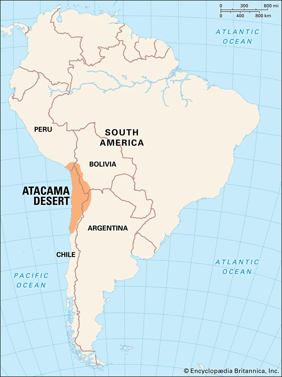
- Location and Geography:
- The Atacama Desert is located in northern Chile, stretching over 1,600 km along the Pacific coast.
- It is one of the driest places on Earth, with annual rainfall averaging less than 15 mm in some areas.
- The desert is bordered by the Pacific Ocean to the west and the Andes Mountains to the east, creating a rain shadow effect that prevents moisture from reaching the region.
- The terrain consists of salt flats, sand dunes, volcanic peaks, and rocky plateaus, making it a harsh but unique landscape.
- San Pedro de Atacama is a key town within the desert, serving as a base for researchers and tourists.
- Formation:
- The extreme aridity of the Atacama Desert is due to the Humboldt Current and the Andean rain shadow effect.
- The Humboldt Current, a cold oceanic current, reduces evaporation and prevents cloud formation, limiting precipitation.
- The Andes Mountains block moist air from the Amazon Basin, reinforcing the desert's dry climate.
- Geological studies suggest that the Atacama has been arid for millions of years, making it one of the oldest deserts in the world.
- Why Telescopes Are Located in the Region:
- The Atacama Desert is home to world-class astronomical observatories, including the Atacama Large Millimetre Array (ALMA), Paranal Observatory, and La Silla Observatory.
- The region has exceptional atmospheric conditions, with low humidity and minimal cloud cover, allowing for clear night skies throughout the year.
- The high altitude of the desert, averaging 2,400 metres above sea level, reduces air turbulence, improving astronomical observations.
- Minimal light pollution historically made it one of the best places on Earth for deep-space observations.
- These conditions allow astronomers to study exoplanets, galaxies, and cosmic radiation with unparalleled clarity.
- Reason Behind Increasing Light Pollution:
- Urban expansion: Growing cities like Antofagasta and Calama are leading to increased artificial lighting.
- Mining activities: The Atacama is rich in copper and lithium, and the lights from mining operations contribute to sky brightness.
- Tourism growth: More visitors mean more infrastructure and lighting, impacting the darkness required for astronomical research.
- Lack of strict regulations: Although some efforts exist to control artificial light, enforcement is weak, allowing pollution to increase.
Chilika Lake
Why in news?
- Tourists and researchers observe Irrawaddy dolphins in Chilika Lake, India, Asia’s largest saltwater lagoon, facing conservation challenges.
About Chilika Lake:
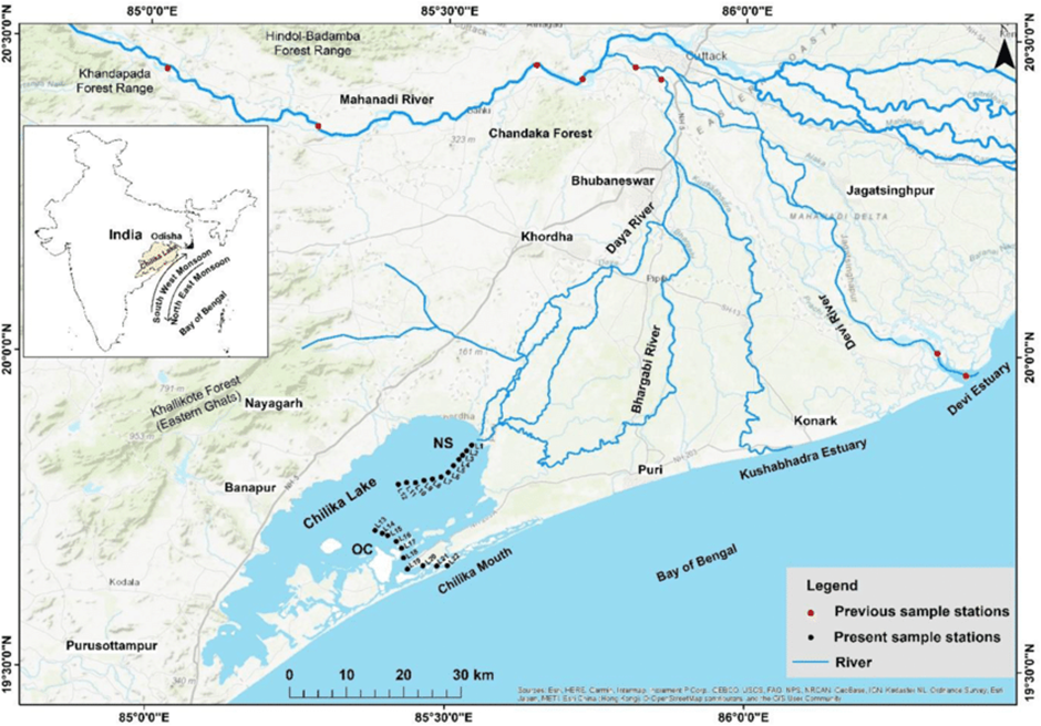
- Location:
- Chilika Lake, the largest coastal lagoon in India and Asia’s biggest saltwater lake, is located in the state of Odisha.
- It spans over 1,100 sq. km across Puri, Khurda, and Ganjam districts and connects to the Bay of Bengal through a narrow sea mouth.
- Ecological Significance:
-
- Chilika is a Ramsar Site, recognised for its rich biodiversity and role as a critical habitat for migratory birds along the East Asian-Australasian Flyway.
- It serves as a breeding ground for fish species and sustains the livelihoods of local fishing communities.
-
- Other Key Features:
- It is home to over 225 species of fish and supports a large fishing industry.
- The Nalabana Bird Sanctuary, within the lake, attracts thousands of migratory birds, including flamingos, pelicans, and herons.
- The lake hosts one of the largest populations of Irrawaddy dolphins, a key attraction for ecotourism.
- Seasonal changes and hydrological variations influence its salinity levels, affecting its diverse aquatic ecosystem.
Irrawaddy Dolphins
- Habitat and Distribution: Irrawaddy dolphins are found in coastal waters of South and Southeast Asia and inhabit three major rivers—the Irrawaddy (Myanmar), Mahakam (Indonesia), and Mekong (China).
- Conservation Status: They are classified as ‘Endangered’ by the IUCN Red List, with a global population of fewer than 7,500 individuals.
- Population in Chilika: The highest single-lagoon population of Irrawaddy dolphins is found in Chilika Lake, making it a crucial conservation site.
- Threats: Habitat degradation, accidental entanglement in fishing nets, and increasing human activities pose significant threats to their survival.
|
UPSC CSE PYQs Q1. The area known as ‘Golan Heights’ sometimes appears in the news in the context of the events related to (2015)
Answer: Option B Q3. Yom Kippur War was fought between which sides/ countries? (2008)
Answer: Option C |
|
Also Read |
|
| FREE NIOS Books | |


PLACES IN NEWS 10th MAY 2025

National Scheme for Industrial Training Institute ITI Upgradation
CCRAS has revived two rare Ayurvedic Manuscript
Karol Bagh Metro Pillar No. 112, Above Domino's, 22B, First Floor, New Delhi - 110060
Copyright © 2024-2026 ENSURE IAS. All rights reserved.