- Courses
- GS Full Course 1 Year
- GS Full Course 2 Year
- GS Full Course 3 Year
- GS Full Course Till Selection
- CSAT
- 5 LAYERED ARJUNA Mentorship
- Public Administration Optional
- Online Program
- GS Recorded Course
- NCERT Batch
- Polity Module Course
- Geography Module Course
- Economy Module Course
- AMAC Module Course
- Modern India, Post Independence & World History Module Course
- Environment Module Course
- Governance Module Course
- Science & Tech. Module Course
- International Relations and Internal Security Module Course
- Disaster Management Module Course
- Ethics Module Course
- Essay Module Course
- Current Affairs Module Course
- ABOUT US
- OUR TOPPERS
- TEST SERIES
- FREE STUDY MATERIAL
- VIDEOS
- CONTACT US
PLACES IN NEWS 22nd APRIL 2025
PLACES IN NEWS 22nd APRIL 2025

Yellow Sea
Why in news?
a. After assertive moves in the South China Sea, China escalates tensions in the Yellow Sea with a massive steel rig.
About Yellow Sea:
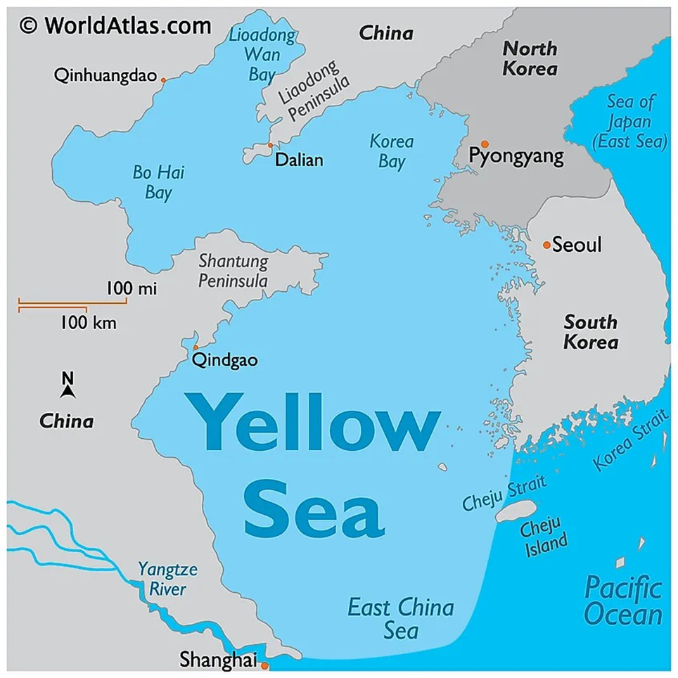
- Geography and Location:
- The Yellow Sea, also referred to as Huang Hai in China and the West Sea in both North and South Korea, is a marginal sea of the Western Pacific Ocean.
- It is located north of the East China Sea and is bordered by mainland China to the north and west, and North Korea and South Korea to the east.
- It derives its name from the yellowish sand particles originating from the Gobi Desert, which colour the sea's surface with a distinctive golden hue.
- The sea covers an area of approximately 400,000 sq. km, measuring 960 km from north to south and about 700 km from east to west.
- With an average depth of 55 to 120 metres, it is one of the world’s largest continental shelf areas submerged in water.
- The climate in the Yellow Sea region is marked by cold, dry winters and wet, warm summers.
- Major rivers that empty into it include the Yangtze, Han, Datung, Yalu, Guang, and Sheyang.
- It also hosts several islands, notably Jeju Island (South Korea), the Shandong Peninsula islands (China), and Ganghwa Island (South Korea).
- Prominent port cities along its coast include Qingdao and Dalian (China),
Inch’ŏn (South Korea), and Namp’o (North Korea).
- Geopolitical Significance and Rising Tensions:
- The Yellow Sea holds immense geostrategic value due to its proximity to major East Asian powers.
- It is crucial for commercial shipping, fisheries, and potential undersea resources like oil and gas.
- Recently, tensions have escalated with China constructing a massive steel rig, signalling its intent to assert maritime dominance beyond the South China Sea.
- The construction has raised concerns in South Korea and regional allies, intensifying military surveillance and diplomatic friction, making the Yellow Sea a new flashpoint in the Indo-Pacific.
Sanjay Gandhi National Park
Why in news?
a. The iconic 'Van Rani' toy train at Mumbai's Sanjay Gandhi National Park is set to resume operations by June 2025.
About Sanjay Gandhi National Park:
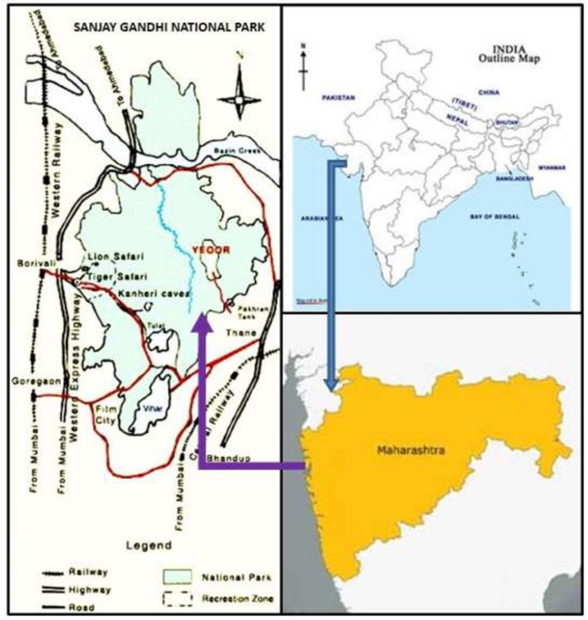
- Geography:
- Sanjay Gandhi National Park, located in Mumbai, Maharashtra, spans approximately 87 square kilometres, making it one of the world’s largest protected urban forests.
- Situated at the northern edge of Mumbai, the park is bordered by densely populated urban settlements, acting as a vital green lung for the metropolitan region.
- Its landscape is marked by rugged terrain, dense forests, and scenic walking trails.
-
- One of the park's most famous landmarks is the Kanheri Caves, a complex of ancient Buddhist rock-cut monuments dating back to the 1st century BCE, offering both historical and spiritual significance.
- Flora and Fauna:
- The park showcases remarkable biodiversity, with its moist deciduous forests, bamboo groves, and seasonal wildflowers creating a lush environment throughout the year.
- These forest systems play an essential ecological role, particularly in carbon sequestration and groundwater recharge.
- The park's fauna includes leopards, spotted deer, blackbucks, civets, and a host of smaller mammals.
- It is also home to more than 270 bird species, including migratory and endemic varieties, along with 170 species of butterflies, various reptiles, and insects, making it a conservation hotspot and a haven for nature enthusiasts and researchers alike.
- Van Rani Toy Train:
- The Van Rani Toy Train, a beloved attraction since 1980, is set to resume operations by June 2025 after a hiatus following Cyclone Tauktae.
- Currently undergoing a ₹40 crore eco-friendly revamp, the new train will feature a battery-operated engine, four bogies, and a Vistadome coach for panoramic views of the park.
- This initiative aims to enhance visitor experience while maintaining the park’s eco-sensitive balance, making it a nostalgic yet modern addition to urban ecotourism.
Hokersar Wetland
Why in news?
a. The Anti-Corruption Bureau (ACB) has registered an FIR in a multi-crore scam involving the dredging of Hokersar Wetland.
About Hokersar Wetland:
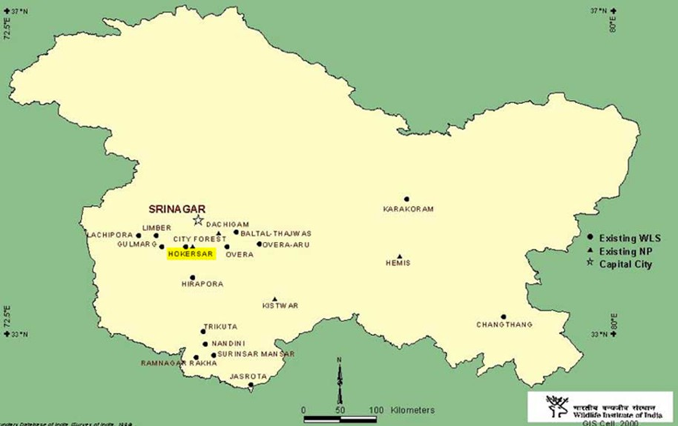
- Location and Geography:
- The Hokersar Wetland, located in Zainakote in the Srinagar district of Jammu & Kashmir, lies approximately 10 km northwest of Srinagar in the Kashmir Valley.
- Spanning over 1,375 hectares, it is the largest bird reserve in the valley and forms a part of the Jhelum River basin.
- Positioned at an elevation of 1,584 metres, it lies at the northern end of the Doodhganga catchment.
- The wetland is fed by two perennial streams — Doodhganga from the east and
Sukhnag from the west.
-
- The region includes a shallow lake and marshes, with water depths rising to 2.4 metres during spring due to snowmelt from the Pir Panjal range. It also acts as a natural flood absorption basin, playing a crucial role in regional hydrology.
- Ecological Significance:
- Hokersar consists of three ecological zones — a macrophyte-rich northeastern zone, a central aquatic zone dominated by Trapa natans and Phragmites, and a southern pasture-like silted zone.
- Recognised as a Ramsar site since 2005, it also falls under the National Wetlands Conservation Programme and is listed among India’s Important Bird Areas.
-
- The wetland serves as a key stopover on the Central Asian Flyway for over 500,000 migratory birds annually, including northern pintails, mallards, gadwalls, shovellers, and several globally threatened species. Birds begin arriving in September and October and depart by May.
- Recent Scam:
- In April 2025, the Anti-Corruption Bureau (ACB) registered an FIR in a multi-crore scam involving the dredging of Hokersar Wetland.
- A ₹20.55 crore project meant for conservation was marred by irregularities in tendering, misreporting of work, and flawed disposal practices, leading to financial loss and ecological degradation.
- Several officials from the Flood Spill Channel Division have been arrested, raising concerns about governance and transparency in wetland conservation.
Nagavali River
a. Authorities in Rayagada district, Odisha, have imposed a penalty of ₹16.17 lakh for illegal sand mining from the Nagavali riverbed.
About Nagavali River:
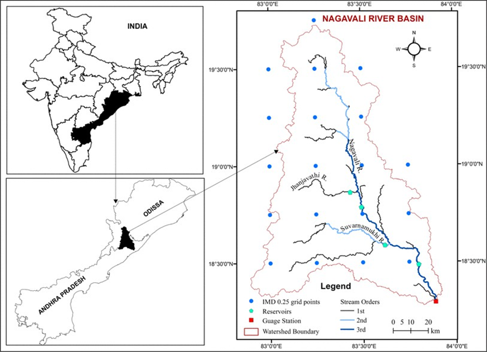
- Geography and Origin:
- The Nagavali River originates from a hill near Lakhbahal village in Thuamul Rampur block, Kalahandi district, Odisha.
- Flowing over a length of 256 km, it travels through Odisha (161 km) and Andhra Pradesh (95 km) before merging into the Bay of Bengal near Kallepalli village in Srikakulam district.
- The river drains a basin area of 9,510 sq. km, with 4,462 sq. km in Odisha and 5,048 sq. km in Andhra Pradesh.
- It receives an average annual rainfall of 1,000 mm, and the terrain is largely hilly and tribal-dominated.
- The river's tributaries include Jhanjavati, Barha, Suvarnamukhi, Vegavathi, and several minor streams.
- Irrigation and Development Projects:
- The Nagavali basin supports multiple irrigation projects crucial for agriculture and rural livelihoods.
- Key among them is the Jhanjavati Rubber Dam, the largest of its kind in Asia, located in Parvathipuram Manyam district.
-
- Designed to irrigate 24,640 acres, it has remained underutilised due to unresolved
interstate disputes with Odisha over reservoir submersion levels.
-
- The Thotapalli Barrage, Madduvalasa Reservoir, and Vengalaraya Sagar are additional projects providing irrigation to thousands of acres across Andhra Pradesh.
- The Narayanapuram barrage plays a pivotal role in water regulation.
- An ambitious Vamsadhara-Nagavali interlink canal is also under development to improve irrigation for an additional 50,000 acres using 10 TMC of surplus water.
- Impacts of illegal sand mining in the region:
- Riverbed Degradation: Continuous and unregulated extraction lowers the riverbed, leading to instability in flow patterns and increased risk of bank erosion.
- Ecological Damage: Sand mining destroys aquatic habitats, affecting fish breeding grounds and disturbing the ecological balance of riverine ecosystems.
- Water Table Depletion: Over-extraction affects groundwater recharge, leading to a decline in local water tables, impacting agriculture and drinking water availability.
- Increased Flood Risk: The natural flood-absorbing capacity of the river is reduced, raising the likelihood of flash floods during monsoon seasons.
- Livelihood Loss: Local communities dependent on fishing and small-scale farming face economic hardship due to degraded river health and reduced water availability.
|
Also Read |
|
| FREE NIOS Books | |


NASA’s PUNCH Mission

NASA’s SPHEREx Telescope: Mapping the Cosmos in 3D

NASA’s Oldest Active Astronaut Returns to Earth on 70th Birthday
Karol Bagh Metro Pillar No. 112, Above Domino's, 22B, First Floor, New Delhi - 110060
Copyright © 2024-2026 ENSURE IAS. All rights reserved.