- Courses
- GS Full Course 1 Year
- GS Full Course 2 Year
- GS Full Course 3 Year
- GS Full Course Till Selection
- CSAT
- 5 LAYERED ARJUNA Mentorship
- Public Administration Optional
- Online Program
- GS Recorded Course
- NCERT Batch
- Polity Module Course
- Geography Module Course
- Economy Module Course
- AMAC Module Course
- Modern India, Post Independence & World History Module Course
- Environment Module Course
- Governance Module Course
- Science & Tech. Module Course
- International Relations and Internal Security Module Course
- Disaster Management Module Course
- Ethics Module Course
- Essay Module Course
- Current Affairs Module Course
- ABOUT US
- OUR TOPPERS
- TEST SERIES
- FREE STUDY MATERIAL
- VIDEOS
- CONTACT US
PLACES IN NEWS 18th FEBRUARY 2025
PLACES IN NEWS 18th FEBRUARY 2025

Katarniaghat Wildlife Sanctuary
Why in news?
- A 45 to 50-year-old male elephant's carcass was recently discovered in the dense forests of Katarniaghat Wildlife Sanctuary (KWS), which is located near the Indo-Nepal border.
About Katarniaghat Wildlife Sanctuary:
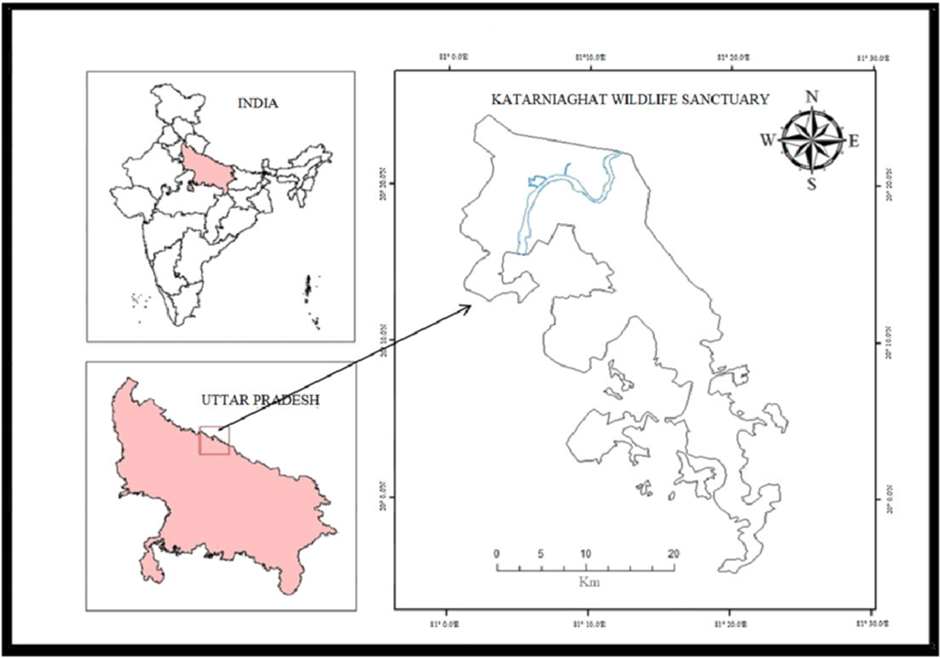
- Location:
- Katarniaghat Wildlife Sanctuary is situated in the Bahraich district of Uttar Pradesh, India. It is located near the Indo-Nepal border and is an integral part of the Dudhwa Tiger Reserve.
- In 1987, the wildlife sanctuary, along with Dudhwa National Park and Kishanpur Wildlife Sanctuary, was brought under the ambit of Project Tiger.
- This led to the establishment of the Dudhwa Tiger Reserve, further strengthening the sanctuary's role in tiger conservation.
- Several rivers and water bodies traverse the sanctuary, including the Girwa River, a tributary of the Ghaghara River. These water sources support the region’s biodiversity, providing critical habitats for aquatic species and sustaining the ecosystem.
- Flora and Fauna:
- The sanctuary features a mix of tropical moist deciduous forests, riverine vegetation, and grasslands, making it an ecologically diverse region. The dominant plant species include sal, teak, and fig trees.
- Katarniaghat serves as a vital habitat for several endangered species, including the Bengal tiger, Indian elephant, and one-horned rhinoceros. It also supports a significant population of swamp deer (barasingha) and Indian gaur.
- The sanctuary plays a crucial role in conserving the gharial, a critically endangered crocodilian species. It is also home to freshwater turtles and the Gangetic dolphin.
- Bird enthusiasts can spot species such as the great hornbill, white-rumped vulture, and swamp francolin, making it a prime birdwatching destination.
- The region also houses reptiles like the Indian rock python and king cobra, along with diverse amphibians that thrive in its wetlands and forests, further emphasising its ecological significance.
Yamuna River
Why in news?
- A major clean-up initiative for the heavily polluted River Yamuna recently began, following a four-pronged strategy designed to restore the river’s health within three years.
About Yamuna River:
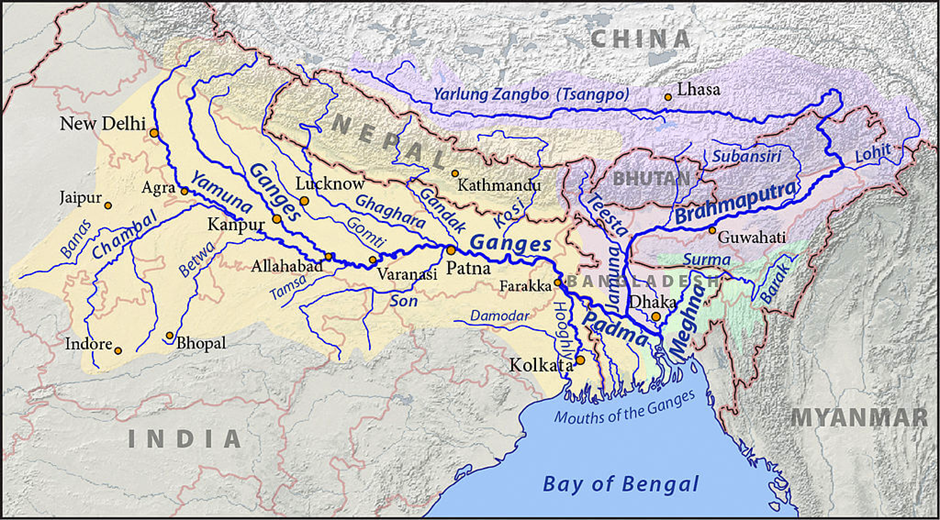
1. Location and Origin:
- The Yamuna River is a major tributary of the Ganga River, originating from the Banderpunch Glacier in the Uttarkashi district of Uttarakhand, India.
- The river is primarily glacier-fed but also relies on monsoon rains, influencing its seasonal flow.
- Flowing for approximately 1,376 kilometres, the Yamuna passes through Uttarakhand, Himachal Pradesh, Haryana, Delhi, Uttar Pradesh, and Madhya Pradesh before merging with the Ganga at Triveni Sangam in Prayagraj, Uttar Pradesh.
- The key tributaries of the Yamuna River include the Tons, Chambal, Betwa, Ken, Sindh, Hindon, Sarda, and Giri rivers. Near Dehradun, it is joined by its largest tributary, the Tons River, while the Chambal River is its biggest tributary.
2. Historical and Cultural Significance:
- The Yamuna holds immense mythological and religious significance in Hinduism. It is worshipped as the goddess Yamuna, believed to cleanse sins and provide spiritual salvation.
- Major historical and cultural centres, including Delhi, Mathura, and Agra, have developed along its banks, with the river playing a vital role in trade, agriculture, and settlement patterns.
- Several iconic landmarks, including the Taj Mahal, stand along the Yamuna, reflecting its historical importance. Additionally, it serves as a lifeline for millions of people, supporting religious ceremonies, festivals, and daily life.
3. Environmental Concerns and Pollution:
- Industrial discharge, untreated sewage, and solid waste dumping have made the Yamuna one of the most polluted rivers in India, especially in Delhi and Uttar Pradesh.
- The Najafgarh Drain and Supplementary Drain contribute significantly to pollution levels, with high concentrations of toxic chemicals, organic waste, and plastic debris.
- The Central Pollution Control Board (CPCB) has classified sections of the river as biologically dead, where oxygen levels are too low to sustain aquatic life.
- Despite its ecological and economic importance, unchecked pollution threatens biodiversity, groundwater quality, and public health, necessitating urgent conservation efforts.
4. Four-Pronged Conservation Strategy for Yamuna:
To rejuvenate the Yamuna within three years, a structured four-pronged strategy has been implemented:
- Clearing the Riverbed:
- Removing trash, garbage, and silt from the Yamuna’s stream to restore water flow and reduce contamination.
- Conducting manual and mechanised cleanup drives to ensure sustained cleanliness.
- Draining the Drains:
- Simultaneous cleanup of major drains, particularly the Najafgarh Drain and Supplementary Drain, which are among the biggest polluters.
- Implementing waste filtration measures to prevent further contamination from urban runoff.
- Fixing Sewage Treatment Plants (STPs):
- Daily monitoring of existing STPs to assess their capacity and efficiency in treating wastewater.
- Upgrading old STPs to enhance their effectiveness and prevent untreated sewage discharge.
- Scaling Up Treatment Capacity:
- Constructing new STPs and Decentralised Sewage Treatment Plants (DSTPs) to manage the 400 MGD shortfall in sewage treatment.
- Expanding wastewater recycling and reuse initiatives to reduce the burden on the river.
Gulf of Aqaba
Why in news?
- The Gulf of Aqaba (Eilat) Coral Reefs has experienced a significant 3,000-year growth shutdown, attributed to rising sea temperatures and environmental stress, threatening the reef’s biodiversity and ecosystem stability.
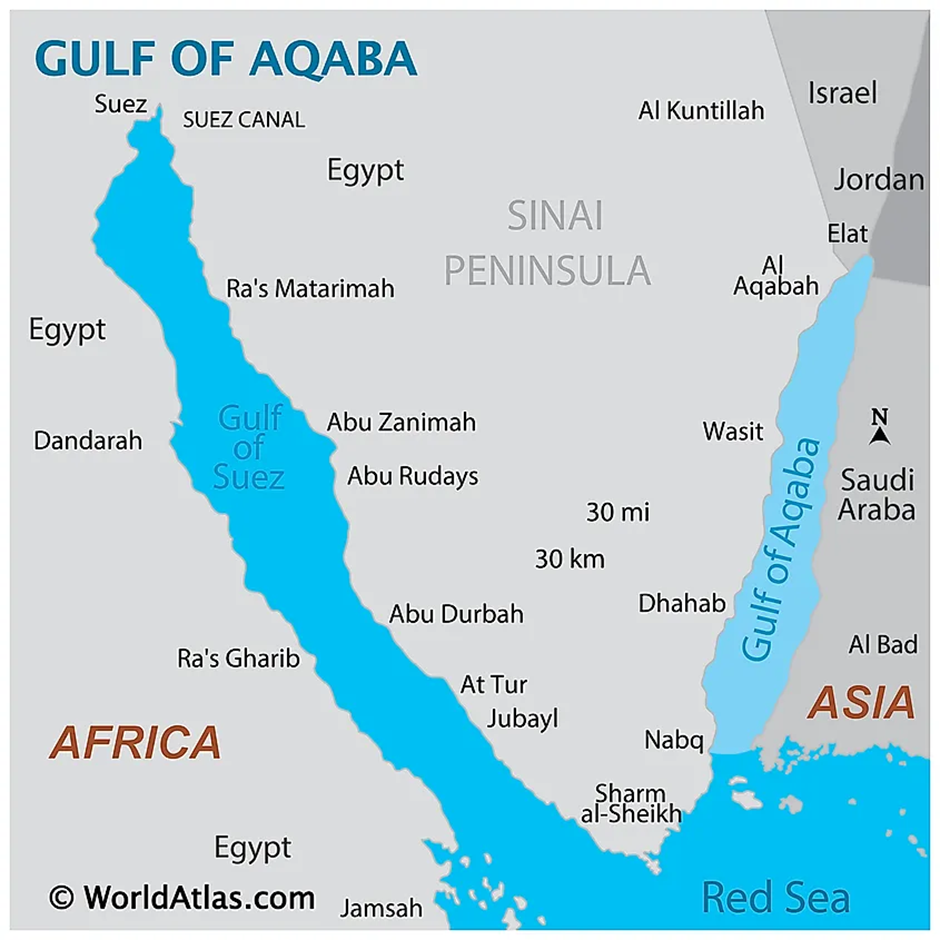
About Gulf of Aqaba:
-
-
- Location and Geography
- Location and Geography
-
- The Gulf of Aqaba, also known as the Gulf of Eilat, is a northern extension of the Red Sea. It lies between the Sinai Peninsula to the west and the Arabian Peninsula to the east, forming a strategic waterway that connects the Red Sea to the Suez Canal.
- The Gulf shares its coastline with four countries: Egypt, Israel, Jordan, and Saudi Arabia.
- The Gulf's northernmost point is marked by cities like Taba (Egypt), Eilat (Israel), and Aqaba (Jordan), which are major urban centres along its coast.
- The Gulf of Aqaba spans a length of about 160 kilometres and features a maximum depth of 1,850 meters, making it significantly deeper than the adjacent Gulf of Suez.
- Its geography is shaped by the Dead Sea Transform, a tectonic fault zone that marks the boundary between the Arabian Plate and the African Plate. This geological formation influences the region's seismic activity and contributes to the gulf’s distinct underwater features.
-
- Coral Ecosystem in the Region
- Coral Ecosystem in the Region
-
- The Gulf of Aqaba is home to some of the world’s northernmost coral reefs, which are crucial for marine biodiversity.
- These coral ecosystems thrive in the warm waters of the gulf, with species such as stony corals, soft corals, and marine fish.
- Despite the gulf's relatively harsh environmental conditions, including high salinity, temperature fluctuations, and minimal freshwater input, these reefs have shown remarkable resilience.
-
- Decline in Coral Growth
- Decline in Coral Growth
-
- The coral reefs in the Gulf of Aqaba are now facing a decline in growth, a trend largely attributed to climate change, particularly rising sea temperatures.
- These temperature shifts have led to coral bleaching, where corals expel their symbiotic algae, weakening the reef’s structure.
- Additionally, increased pollution, particularly from urban runoff, untreated sewage, and industrial waste, has negatively affected water quality, further stressing the ecosystem.
- Human activities, including overfishing and coastal development, have also played a role in degrading the reef's health.
- The combined impact of these factors has led to a significant slowdown in coral growth, threatening the region's rich marine biodiversity and the livelihood of local communities dependent on these ecosystems.
Chirang-Ripu Elephant Reserve
Why in news?
- The Assam government has declared the Chirang-Ripu Elephant Reserve as the 8th National Park, which will be named Sikhna Jwhwlao National Park, further boosting wildlife conservation efforts in the state.
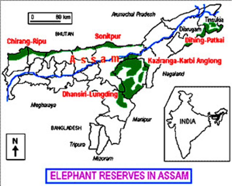
About Chirang-Ripu Elephant Reserve:
-
-
- Location:
- Location:
-
- The Chirang-Ripu Elephant Reserve is located in western Assam, bordering West Bengal, and forms part of the buffer zone of the renowned Manas Tiger Reserve (TR).
- The reserve is an ecologically significant area, encompassing two contiguous forests—Ripu and Chirang—which play a vital role in wildlife conservation.
- It is strategically situated as a conservation corridor linking Buxa Tiger Reserve in West Bengal, Phipsu Wildlife Sanctuary in Bhutan, Royal Manas National Park in Bhutan, and Manas National Park in India, forming a crucial part of the larger transboundary ecosystem.
-
- Flora and Fauna:
- Flora and Fauna:
-
- The reserve is home to diverse flora, including tropical moist deciduous forests, grasslands, and riverine vegetation, providing rich habitats for various species.
- It is particularly notable for supporting the largest known population of the endangered Golden Langur (EN).
- The area is also a critical habitat for Asian elephants and other wildlife species like tigers, rhinos, and various species of primates.
Difference between National Park and Wildlife Sanctuary:
|
Parameters |
National Park |
Wildlife Sanctuary |
|
Meaning |
A national park is a designated area where wildlife is protected and can thrive in their natural environment without human interference. |
A wildlife sanctuary is a protected space where wildlife and their habitats are shielded from external disturbances. |
|
Nature |
National parks aim to conserve not just wildlife, but also the natural landscapes, flora, and cultural heritage. |
Wildlife sanctuaries focus on the preservation of a wide variety of species, including insects, animals, birds, and microorganisms. |
|
Objective |
National parks are dedicated to maintaining the natural beauty, environmental integrity, and cultural significance of the area. |
The primary goal of wildlife sanctuaries is to safeguard wildlife populations and their natural habitats from destruction. |
|
Restrictions |
National parks are highly regulated areas, with stringent controls on access and activities. |
Wildlife sanctuaries are more relaxed in terms of restrictions, allowing more flexibility in human presence and activities. |
|
Permissions Required |
Visiting a national park generally requires formal approval from the relevant authorities. |
Wildlife sanctuaries usually do not require formal permission for visits, except for regulated activities. |
|
Boundaries |
The boundaries of national parks are clearly defined and strictly enforced. |
Wildlife sanctuaries may not always have clearly demarcated boundaries, offering some flexibility in terms of space. |
|
Human Activity |
Human activity is heavily restricted or outright banned in national parks to minimize impact on wildlife. |
Some human activities, such as regulated tourism and traditional practices, may be allowed in wildlife sanctuaries. |
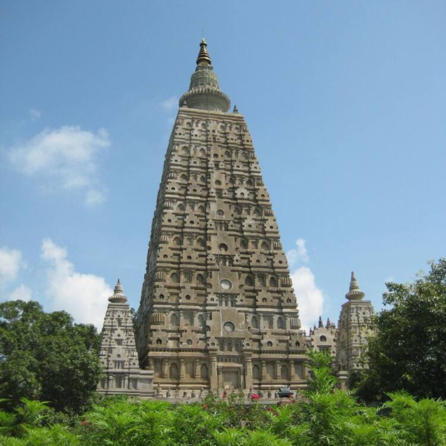
Mahabodhi Temple
Why in news?
- The plastic ban at the Mahabodhi Temple has been reinforced to ensure a cleaner and more sustainable environment.
About Mahabodhi Temple:
-
-
- Location:
- Location:
-
- The Mahabodhi Temple in Bodh Gaya, Bihar, stands as one of the most revered Buddhist sites, marking the spot where Lord Buddha attained Enlightenment (Bodhi) under the sacred Bodhi Tree.
- The temple is located on the banks of the Niranjana River and is one of the four major pilgrimage sites linked to Buddha’s life.
-
- Historical Establishment:
- Historical Establishment:
-
- The first temple was constructed by Emperor Ashoka in the 3rd century BCE, making it one of the earliest structures dedicated to Buddha’s enlightenment.
- The current temple, dating back to the 5th or 6th century, is one of the few surviving examples of early brick architecture in India.
- It significantly influenced the evolution of brick construction over time.
- The Mahabodhi Temple was recognised as a UNESCO World Heritage Site in 2002, highlighting its cultural and historical importance.
-
- Key Features:
- Key Features:
-
- Temple Structure: The temple stands at a towering height of 50 meters and features a pyramidal shikhara (tower) with multiple layers of niches, arch motifs, and exquisite engravings. The tower is an iconic representation of Buddhist architecture, symbolising the path to enlightenment.
- Bodhi Tree: A direct descendant of the original tree under which Buddha meditated, the Bodhi Tree is a central feature of the temple complex. It continues to attract pilgrims who come to meditate and pay homage.
- Buddha's Vajrasana: Located near the Bodhi Tree, Buddha’s Vajrasana (or “diamond throne”) is the spot where Buddha is believed to have sat during his meditation and attained enlightenment. A stone slab marking the exact location is part of the sacred site.
- Buddha Statue: Inside the temple, there is a yellow sandstone statue of Buddha, encased in glass, symbolising Buddha's serene enlightenment. This statue is an important focal point for devotees.
- Surrounding Towers: Four smaller towers, identical to the central tower but slightly smaller in size, are placed at the corners of the two-story structure. These towers are topped with umbrella-like domes, adding to the temple’s grandeur.
UPSC CSE PYQsQ. Consider the following pairs:
Which of the pairs given above are correctly matched? (2019)
Answer: Option A |
|
Also Read |
|
| FREE NIOS Books | |

Simla Agreement and Its Suspension by Pakistan (2025)

5 Years of SVAMITVA Scheme

UNODC Report on Expansion of Organized Crime Groups
Karol Bagh Metro Pillar No. 112, Above Domino's, 22B, First Floor, New Delhi - 110060
Copyright © 2024-2026 ENSURE IAS. All rights reserved.