- Courses
- GS Full Course 1 Year
- GS Full Course 2 Year
- GS Full Course 3 Year
- GS Full Course Till Selection
- Online Program
- GS Recorded Course
- NCERT (Recorded 500+ Hours)
- Polity Recorded Course
- Geography Recorded Course
- Economy Recorded Course
- AMAC Recorded Course
- Modern India, Post Independence & World History
- Environment Recoded Course
- Governance Recoded Course
- Science & Tech. Recoded Course
- International Relations and Internal Security Recorded Course
- Disaster Management Module Course
- Ethics Recoded Course
- Essay Recoded Course
- Current Affairs Recoded Course
- CSAT
- 5 LAYERED ARJUNA Mentorship
- Public Administration Optional
- ABOUT US
- OUR TOPPERS
- TEST SERIES
- FREE STUDY MATERIAL
- VIDEOS
- CONTACT US
PLACES IN NEWS 12 NOVEMBER 2024
PLACES IN NEWS 12 NOVEMBER 2024
Toto Tribe
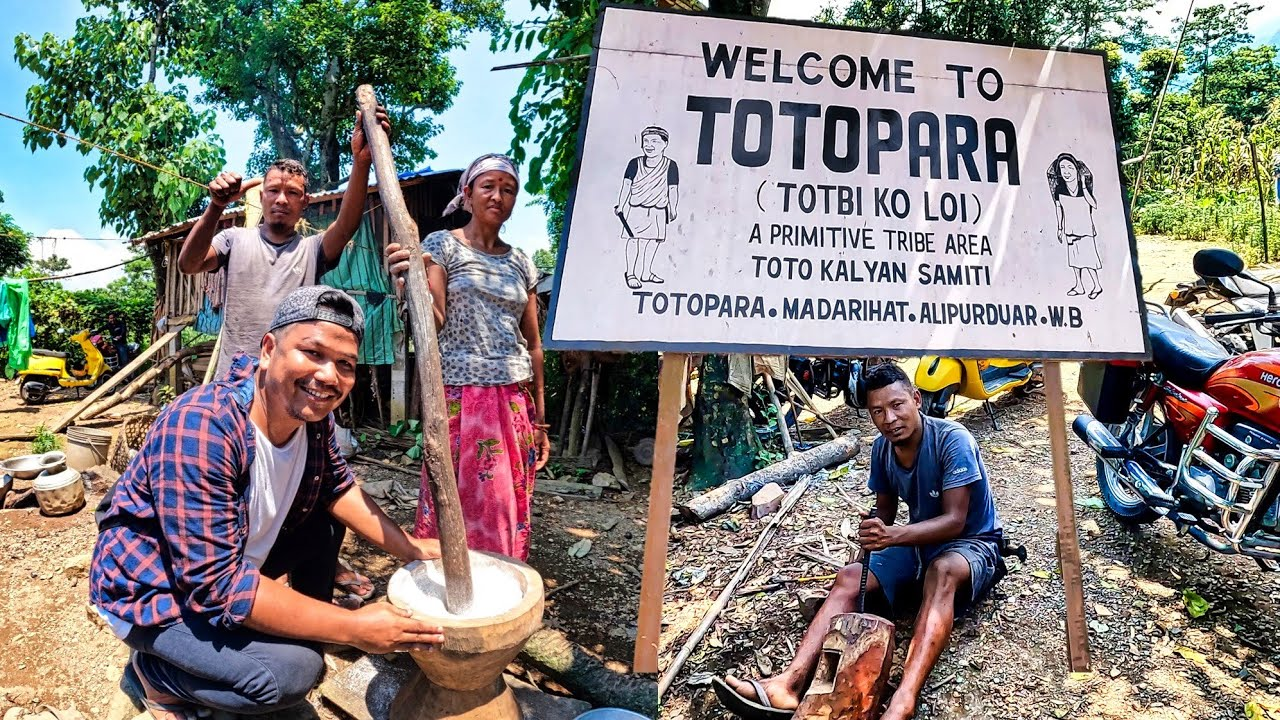
Totos were in the news in November 2024, because Totos are one of the smallest tribes in the world, live in Totopara off West Bengal but are fighting for identity and suffering from infrastructure woes.
About the Toto Tribe:
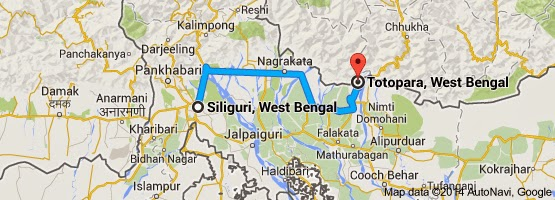
- Location: The Toto Tribe is concentrated in Totopara village in Alipurduar district, West Bengal. The village lies near the Jaldapara Wildlife Sanctuary, just south of the border between Bhutan and West Bengal, on the banks of the Torsa River.
- Ethnicity: The Toto people belong to the Tibetan-Mongoloid ethnic group.
- Population: With fewer than 1,600 members, the Toto tribe is considered one of the most endangered tribes in the world.
- Tribal Status: They are recognized as a Particularly Vulnerable Tribal Group (PVTG).
Culture and Society:
- Language: The Toto language is a Sino-Tibetan language written in the Bengali script.
- Social Structure: Totos are endogamous (marry within their group) but divided into 13 exogamous clans, from which they select marriage partners.
- Marriage: Totos practice monogamy, with a strong cultural stance against dowry systems, which contrasts with neighboring tribal practices.
- Housing: Their houses are elevated bamboo huts with thatched roofs.
- Beliefs: The Toto people are Hindus but also worship nature in their belief system.
- Economy:
- Historically, the Totos were food gatherers and practiced slash-and-burn cultivation.
- They also worked as porters, carrying oranges from Bhutan to Totopara, contributing to their economy.
- Over time, they have transitioned to being settled agriculturists.
Particularly Vulnerable Tribal Groups (PVTGs)
- PVTGs are a subset of tribal groups that face extreme vulnerability. These tribes typically exhibit traits like:
- Primitive traits and geographical isolation.
- Low literacy and zero/negative population growth.
- Heavy reliance on hunting and pre-agriculture technologies.
- Current Statistics:
- Around 2.8 million people belong to 75 PVTGs.
- They live across 22,544 villages in 220 districts spread across 18 states and Union Territories in India.
Amchang Wildlife Sanctuary
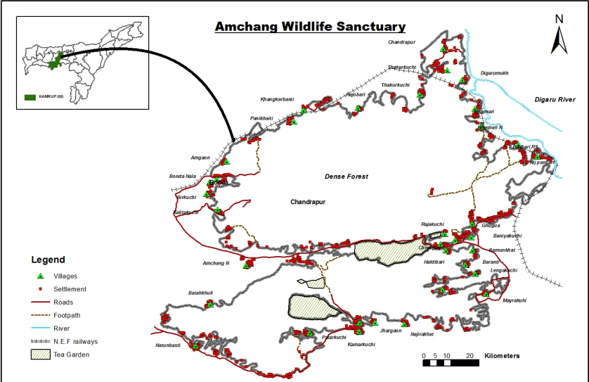
In November 2024, A highly decomposed elephant carcass was discovered in the Khanapara range of the Amchang Wildlife Sanctuary.
About Amchang Wildlife Sanctuary:
- Location: Situated in the state of Assam, India.
- Area: The sanctuary is formed by the amalgamation of three Reserve Forests:
- Khanapara
- Amchang
- South Amchang
- Geography: The sanctuary spans from the Brahmaputra River in the north to the hilly forests of Meghalaya in the south, forming a continuous forest belt through the Maradakdola Reserve Forests of Meghalaya.
Flora:
- The sanctuary is home to several distinct forest types:
- Khasi Hill Sal Forests
- East Himalayan Mixed Deciduous Forest
- Eastern Alluvial Secondary Semi-evergreen Forests
- East Himalayan Sal Forests
Fauna:
- The sanctuary is rich in wildlife, including:
- Flying fox
- Slow loris
- Assamese macaque
- Rhesus macaque
- Hoolock gibbon
- Porcupine
- White-backed vulture
- Slender-billed vulture
- Butterfly Species: The sanctuary is also home to the Tree Yellow Butterfly (Gancana harina), a species indigenous to Thailand, Malaysia, Singapore, and northeast India.
Sutlej River
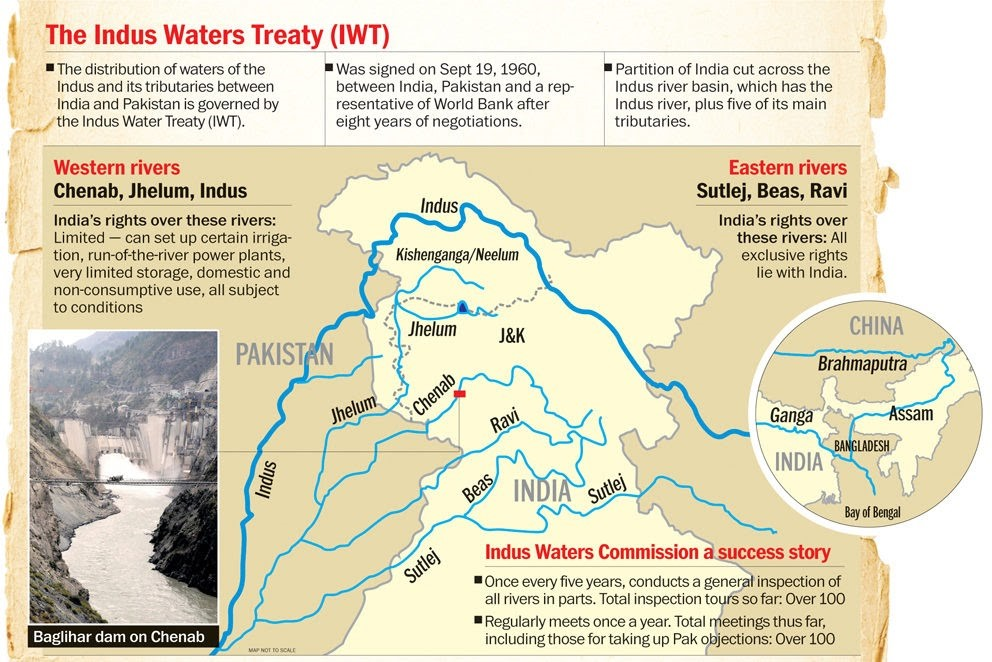
In November 2024, There has been rising anger in Sri Ganganagar district, Rajasthan, against alleged pollution in the Sutlej River, reportedly caused by factories in neighboring Punjab.
About Sutlej River:
- Position: The Sutlej is the longest of the five tributaries of the Indus River and is also known as Satadree.
- Geography:
- Located north of the Vindhya Range, east of the Pakistani Central Makran Range, and south of the Hindu Kush region.
Course of the River:
- Origin: The Sutlej rises on the north slope of the Himalayas in Lake Rakshastal in southwestern Tibet, at an elevation of over 15,000 feet (4,600 meters).
- It is one of three Trans-Himalayan rivers originating in the Tibetan Plateau, the others being the Indus and the Brahmaputra.
-
Flow Through India:
- The river enters India through the Shipki La Pass in Himachal Pradesh at an altitude of 6,608 meters.
- It then flows west and south-west through Punjab, near Nangal, before meeting the Beas River.
- The confluence of the Sutlej and Beas forms 105 km of the India-Pakistan border.
- The river continues for another 350 km before merging with the Chenab River.
- The combination of the Sutlej and Chenab forms the Panjnad River, which eventually flows into the Indus River.
- Length: The Sutlej has a total length of 1,550 km, with 529 km of its course in Pakistan.
Hydrology:
- The river's hydrology is influenced by spring and summer snowmelt in the Himalayas and by the South Asian monsoon.
Tributaries:
- Key tributaries of the Sutlej include:
- Baspa
- Spiti
- Nogli Khad
- Soan River
Water Allocation & Hydroelectric Projects:
- Under the Indus Waters Treaty (1960), water from the Sutlej River has been allocated to India.
- There are several major hydroelectric projects on the Sutlej River, including:
- Bhakra Dam (1,000 MW)
- Karcham Wangtoo Hydroelectric Plant (1,000 MW)
- Nathpa Jhakri Dam (1,530 MW)
Scarborough Shoal
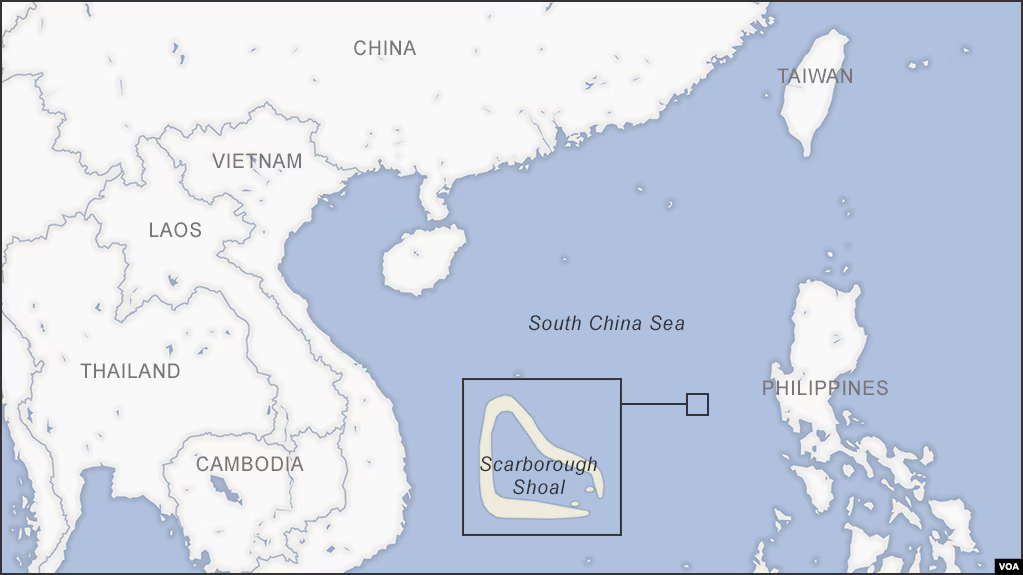
In November 2024, China released geographic coordinates marking baselines around the contested Scarborough Shoal in the South China Sea, further intensifying the ongoing territorial dispute.
About Scarborough Shoal:
- Type: The Scarborough Shoal (also known as Scarborough Reef) is an oceanic coral atoll that developed on top of a seamount, forming a triangle shape in the eastern part of the South China Sea.
- Location: It lies about 220 kilometers west of the Philippines' Island of Luzon.
- Size:
- It is the largest atoll in the South China Sea, though it is submerged at high tide, with only a few rocks visible above sea level.
- The atoll extends 18 km along its northwest-southeast axis and reaches 10 km along its northeast-southwest axis.
-
Ecological Significance:
- The deep waters surrounding the shoal make it a productive fishing area, rich in marine life.
- Its lagoon contains many commercially valuable shellfish and sea cucumbers.
Dispute and Territorial Claims:
- China's Claim:
- China controls the shoal and refers to it as Huangyan Island.
- China makes a historical claim to the area, tracing its ownership back to the Yuan Dynasty in the 1200s.
- Philippines' Claim:
- The Philippines claims the shoal based on its proximity to the Philippines' main island of Luzon (about 500 miles from China).
- The shoal is considered part of the Philippines' 200-nautical mile exclusive economic zone (EEZ), according to the 1982 United Nations Convention on the Law of the Sea (UNCLOS).
- Control: Although there are no permanent structures on the shoal, it is effectively controlled by China, which has maintained a constant coast guard presence since 2012.
Significance:
- The Scarborough Shoal remains a source of a longstanding territorial dispute between China and the Philippines, with both nations claiming exclusive rights to the waters surrounding it.
Hokersar Wetland
Recent Issue: The Hokersar Wetland in the Kashmir Valley has been facing a lack of water due to excess deficit rainfall in recent years, which has impacted the arrival of migratory bird populations in the region.
About Hokersar Wetland:
- Nickname: Known as the ‘Queen Wetland of Kashmir’.
- Location: Situated in Srinagar, Jammu and Kashmir.
- Status: It is a designated Ramsar site, highlighting its ecological significance.
- Type: A natural perennial wetland, contiguous with the Jhelum basin.
- Water Source: Receives water from the Doodhganga River, a tributary of the Jhelum River.
- Geography: Located in the northwest Himalayan biogeographic province of Kashmir, at the foot of the Pir Panchal Range, which is often snow-covered.
Fauna:
- Reedbeds: Hokersar is the only site with remaining reedbeds in Kashmir.
- Waterfowl Species: It serves as a pathway for over 68 species of waterfowl, including:
- Large Egret
- Great Crested Grebe
- Little Cormorant
- Common Shelduck
- Tufted Duck
- Endangered White-eyed Pochard
- Ecological Importance:
- Hokersar is an important feeding and breeding ground for a variety of water birds.
- It is a crucial source of food, spawning ground, and nursery for fish.
What is the Ramsar Convention?
- Purpose: The Ramsar Convention was signed on 2nd February 1971 to preserve the ecological character of wetlands of international importance.
- Name: The treaty is named after Ramsar, a city in Iran, where the agreement was signed.
- Ramsar Sites: Wetlands designated under the convention are given the title of ‘Ramsar site’.
What are the main tributaries of the Jhelum River?
- The largest tributary of the Jhelum River is the Kishenganga (Neelum) River, which joins the Jhelum near Muzaffarabad and flows into the Punjab province of Pakistan.
- The second largest tributary is the Kunhar River, which connects Pakistan-occupied Kashmir (PoK) and Pakistan via the Kohala Bridge in Kanghan Valley.
- Other notable tributaries include:
- Sandran River
- Bringi River
- Arapath River
- Watlara River
- Lidder River
- Veshaw River

Must Check: Best IAS Coaching In Delhi
UPSC Prelims Result 2024 Out: Expected Cut Off & Other Details, UPSC Prelims 2024 Answer with Explanation, Daily Prelims Quiz, Daily Current Affairs, MONTHLY CURRENT AFFAIRS TOTAL (CAT) MAGAZINE, Best IAS Coaching Institute in Karol Bagh, Best IAS Coaching Institute in Delhi, Daily Mains Question Answer Practice, ENSURE IAS UPSC Toppers, UPSC Toppers Marksheet, Previous Year Interview Questions, UPSC Syllabus

Yala Glacier Declared Dead – Climate Change & Himalayan Cryosphere
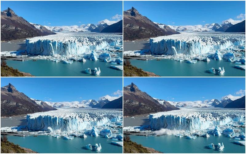
Perito Moreno Glacier Retreat – A Stable Giant Now in Decline
Panchayat Advancement Index (PAI) : Using Local Data for Better Governance
Karol Bagh Metro Pillar No. 112, Above Domino's, 22B, First Floor, New Delhi - 110060
Very Important Instruction For Any Issue, Student Must Produce His/Her Fee Receipt. Without Fee Receipt, It Will Not Be Possible To Track Your Details. If You Have Been Given Any Special Consideration, You Must Keep That In Writing And Produce In Case Of Conflict.
Copyright © 2024-2026 ENSURE IAS. All rights reserved.