- Courses
- GS Full Course 1 Year
- GS Full Course 2 Year
- GS Full Course 3 Year
- GS Full Course Till Selection
- Online Program
- GS Recorded Course
- NCERT (Recorded 500+ Hours)
- Polity Recorded Course
- Geography Recorded Course
- Economy Recorded Course
- AMAC Recorded Course
- Modern India, Post Independence & World History
- Environment Recoded Course
- Governance Recoded Course
- Science & Tech. Recoded Course
- International Relations and Internal Security Recorded Course
- Disaster Management Module Course
- Ethics Recoded Course
- Essay Recoded Course
- Current Affairs Recoded Course
- CSAT
- 5 LAYERED ARJUNA Mentorship
- Public Administration Optional
- ABOUT US
- OUR TOPPERS
- TEST SERIES
- FREE STUDY MATERIAL
- VIDEOS
- CONTACT US
PLACES IN NEWS 11 DECEMBER 2024
PLACES IN NEWS 11 DECEMBER 2024
Sudan
Why in news?
- On December 11, a Sudanese military airstrike hit a market in Kabkabiya, North Darfur, killing over 100 people and injuring hundreds more. The attack occurred amid ongoing clashes in the war-torn country.
- Kabkabiya is located 180 km west of El-Fasher, which has been under siege by the paramilitary Rapid Support Forces (RSF) since May. The incident highlights the escalating violence and humanitarian crisis in Sudan's Darfur region.
About Sudan:
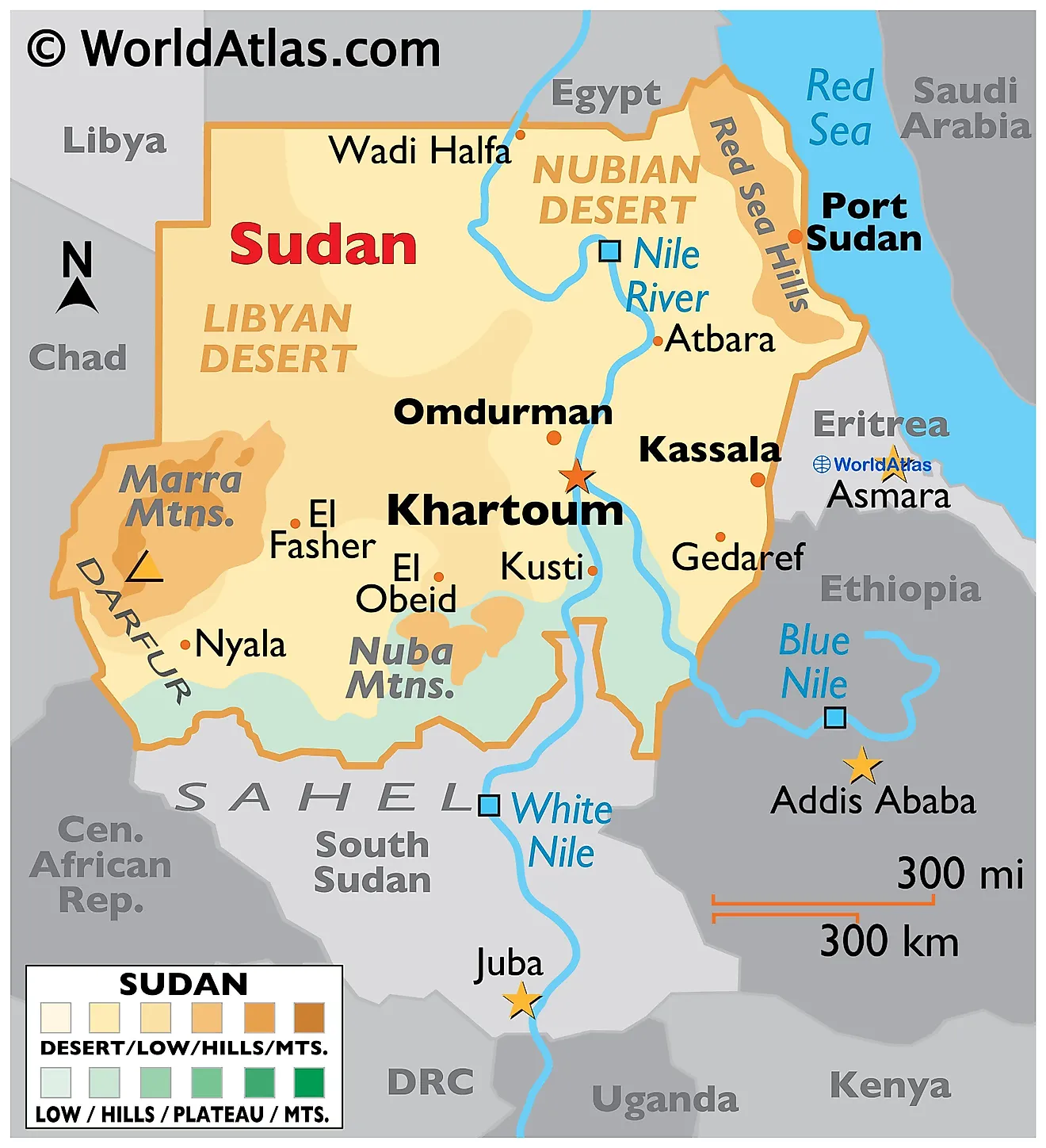
- Sudan is located in northeastern Africa and is the third-largest country on the continent, covering approximately 1.9 million square kilometres.
- It shares borders with seven countries, including Egypt, Ethiopia, and South Sudan, and has a coastline along the Red Sea to the northeast.
- The country’s terrain is diverse, with vast deserts, savannas, and mountain ranges, such as the Marrah Mountains in Darfur and the Red Sea Hills.
- The Nile River and its tributaries, the Blue and White Nile, are critical geographic features that sustain agriculture and livelihoods.
- Sudan’s climate varies, with arid conditions in the north and more tropical climates in the south. Seasonal rains, particularly during the June–September wet season, play a crucial role in agriculture but also lead to frequent flooding.
- Rich in natural resources, Sudan has oil reserves, particularly in the south, though their significance declined after South Sudan's secession in 2011. It also possesses substantial gold deposits, making it a major producer in Africa.
- Other resources include chromium, copper, iron ore, and uranium, alongside vast expanses of arable land. Despite its wealth of resources, Sudan faces challenges in effective use due to political instability and conflict.
About Sudan Civil crisis:
- The Sudan civil crisis stems from long-standing political, ethnic, and economic tensions. It has roots in the Darfur conflict (2003), sparked by rebellion against marginalization by Khartoum. The government, backed by militias, responded violently, leading to mass atrocities.
- In 2019, the overthrow of President Omar al-Bashir, who ruled for 30 years, triggered a power struggle between the military and civilian forces seeking democratic governance.
- In April 2023, tensions between Sudan’s Armed Forces (SAF) and the Rapid Support Forces (RSF)—a paramilitary group—erupted into full-scale conflict.
- The RSF was originally government-supported militia, which evolved into a powerful faction seeking dominance.
- Fighting has devastated Khartoum, the capital, and spread to regions like Darfur, Kordofan, and Blue Nile, causing severe civilian suffering.
- The Darfur region, particularly in El-Geneina and North Darfur, has faced ethnic violence and systematic attacks, with markets, hospitals, and homes destroyed.
- Over 4 million people have been displaced, and more than 20 million face food insecurity.
- International efforts for a ceasefire have failed, with sporadic agreements repeatedly violated.
- The crisis has destabilized border regions and threatens neighbouring countries like Chad and South Sudan, compounding the humanitarian catastrophe.
Ramappa Temple
Why in news?
- The Centre has allocated ₹73 crore under the Special Assistance to States/Union Territories for Capital Investment (SASCI) scheme to develop the Ramappa Temple in Telangana, a UNESCO World Heritage Site since 2021, as a major tourist destination.
About Ramappa Temple:
- The Ramappa Temple, also known as the Rudreshwara Temple, is located in Palampet village, Telangana.
- It was constructed in 1213 AD under the patronage of Kakatiya ruler Ganapathi Deva and executed by Chief Commander Rudra Samani.
- The Ramappa Temple was named after Ramappa, the chief sculptor and architect who led the construction of the temple. It is one of the rare instances in Indian history where a temple is named after its sculptor rather than the deity it enshrines. This reflects the exceptional craftsmanship and ingenuity displayed in the temple’s construction.
- Due to its intricate carvings and innovative engineering, the temple is recognised as a UNESCO World Heritage Site in 2021.
- The temple stands on a 6-foot-high cruciform platform, with its sanctum crowned by a majestic shikharam (spire). The Nandi mandapam at the entrance houses a finely sculpted Nandi. The temple's design emphasises symmetry, with a surrounding pradakshina patha (circumambulatory path).
- The Ramappa Temple is renowned for its structural integrity and innovative design, which showcase the advanced engineering skills of the Kakatiya dynasty. One of its most remarkable features is its ability to withstand natural calamities, including earthquakes.
- The temple was constructed using lightweight floating bricks, which contribute to its strength and flexibility. These bricks, unique to the temple, are believed to have been specially crafted to reduce the weight of the structure while maintaining durability. The careful use of these bricks, combined with the interlocking design of the temple’s beams and pillars, provides a high degree of earthquake resistance.
- The Kakatiya architectural style, blending artistry and structural ingenuity, reflects the dynasty’s rich cultural heritage and engineering excellence.
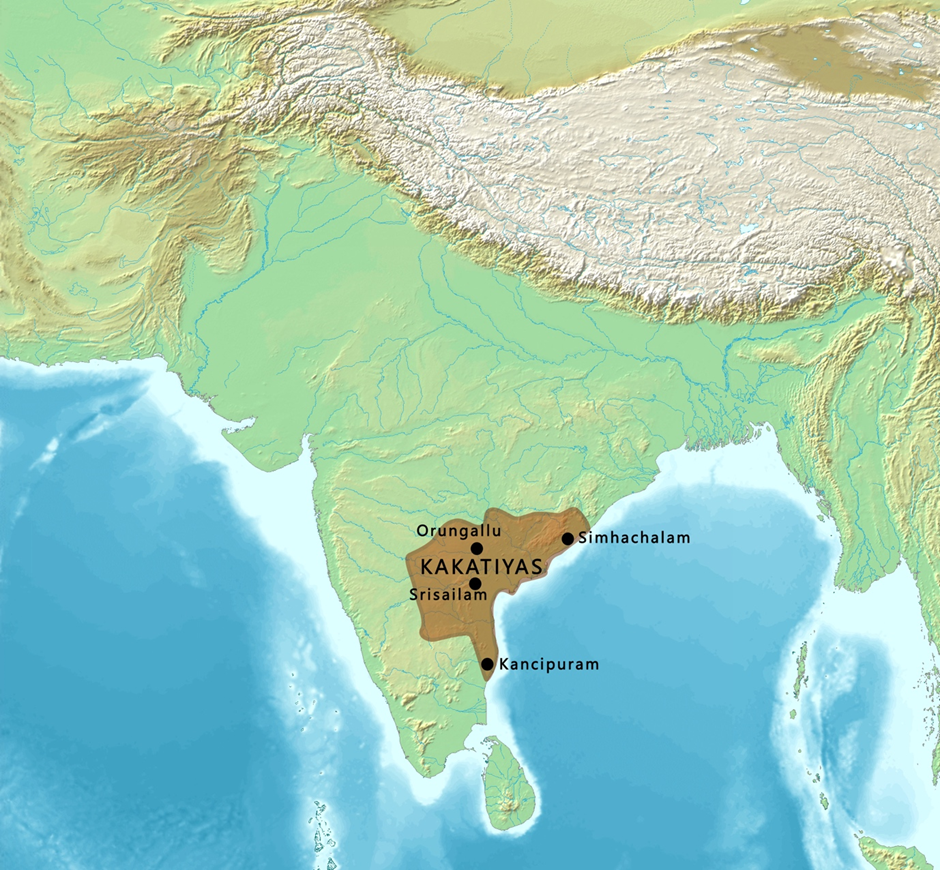
About Kakatiya Dynasty:
- The Kakatiya dynasty ruled from approximately the 12th century to the 14th century (1163–1323 CE), dominating the Telangana region and parts of present-day Andhra Pradesh.
- The rulers of this dynasty were honoured with the titles "Rayagajakeshari" and "Dayagajakeshari," symbolising their prowess and dominance.
- Rudrama Devi (c. 1259–1289 CE), one of the few female rulers in Indian history, was a prominent Kakatiya monarch who expanded the empire and strengthened administration. Her successor, Prataparudra II (c. 1289–1323 CE), was the last significant ruler before the dynasty fell to the Delhi Sultanate.
trade and economy:
- They established a robust economy through agriculture, internal trade, and foreign commerce, facilitating prosperity.
- Important ports like Motupalli and Kakinada flourished under their reign, serving as gateways for maritime trade with Southeast Asia, China, and Arab countries.
- At Motupalli, the Kakatiya rulers issued the famous Motupalli inscription, ensuring security for merchants and emphasising their support for trade.
- Exports included spices, textiles, and diamonds, while imports comprised luxury goods, horses, and precious metals.
art and architecture:
- They left a lasting legacy through their architecture, with structures like Warangal Fort, Thousand Pillar Temple, and Ramappa Temple. Their unique architectural style emphasised ornate carvings, stone pillars, and intricate sculptures, blending spiritual and artistic elements.
- The dynasty also fostered literature, dance, and poetry, contributing significantly to Telugu culture. Their patronage of art and architecture has left an enduring mark on the region's heritage.
Simplipal Biosphere reserve
Why in news?
- The Simlipal Biosphere Reserve in Odisha is under significant pressure due to human activity.
- The tiger population has drastically declined from over 100 in 2002 to just 16 in 2022, while elephant populations face threats from poaching.
- The reserve's buffer areas are densely populated with tribal communities reliant on the forest for livelihood, exacerbating the strain on natural resources.
- Although some experts emphasise the need for better management and community involvement in conservation, the Forest Department faces challenges due to limited resources, anthropogenic pressures, and forced relocations disrupting tribal lifestyles.
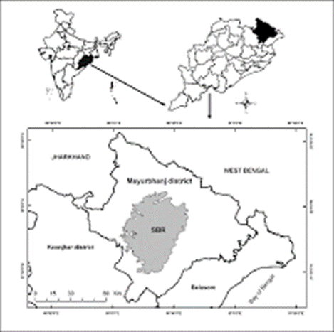
About Simlipal Biosphere Reserve:
- Simlipal Biosphere Reserve is located in the Mayurbhanj district of Odisha, covering an area of 4,374 square kilometers. It is the sixth largest biosphere reserve in India and forms a significant part of the World Network of Biosphere Reserves under UNESCO's Man and Biosphere (MAB) program.
- It is part of the Similipal-Kuldiha-Hadgarh Elephant Reserve, popularly known as the Mayurbhanj Elephant Reserve, which includes 3 protected areas, i.e., Similipal Tiger Reserve, Hadagarh Wildlife Sanctuary, and Kuldiha Wildlife Sanctuary.
- Geographically, Simlipal is part of the Eastern Ghats, and it is situated between the Meghasan Hills and the Chilika Lake. The reserve consists of a core forest area of 845 square kilometres, which is designated as a tiger reserve, a buffer zone of 2,129 square kilometres, and a transition area of 1,400 square kilometres.
- The region's landscape is characterised by mountainous terrain, dense forests, and numerous rivers, with the Subarnarekha, Baitarani, and Kharkai rivers passing through it.
- The flora in Simlipal is incredibly diverse, with over 1,000 plant species, including medicinal plants, timber trees, and wild shrubs. The reserve is known for its extensive sal forests, bamboo groves, and teak plantations.
- The fauna of Simlipal is equally rich, hosting various species of mammals, birds, reptiles, and amphibians. It is home to the Royal Bengal tiger, elephants, leopards, wild boar, and several species of deer. The reserve is also known for its birdlife, including the Indian hornbill and the Bengal florican.
About Man and Biosphere reserves (MAB):
- UNESCO's Man and the Biosphere (MAB) is an international scientific program aimed at promoting sustainable development and biodiversity conservation through the establishment of biosphere reserves.
- MAB was launched in 1971 with the goal of fostering a balanced relationship between humans and nature by creating areas that are protected while allowing for sustainable human development.
- A biosphere reserve under MAB is a region designated by UNESCO as an area for conservation of biological diversity and also to support sustainable livelihoods for the local communities.
- Biosphere reserves are organized into core areas, buffer zones, and transition zones to balance conservation, education, and research with human activity.
- The program encourages scientific research, public awareness, and the implementation of sustainable land use practices.
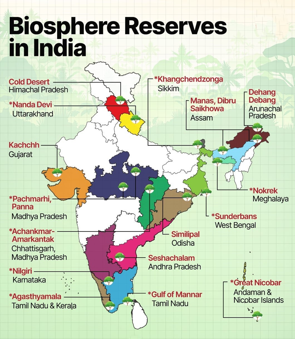
Biosphere reserves list:
|
Year |
Name |
State |
Key fauna |
Area (km2) |
|
|
1. |
1986 |
Nilgiri Biosphere Reserve (part of MAB) |
Karnataka, Tamil Nadu and Kerala |
Nilgiri tahr, tiger, lion-tailed macaque |
5520 |
|
2. |
1988 |
Nanda Devi Biosphere Reserve (part of MAB) |
Uttarakhand |
Snow leopard, Himalayan black bear |
5860 |
|
3. |
1988 |
Nokrek (part of MAB) |
Meghalaya |
Red panda |
820 |
|
4. |
1989 |
Gulf of Mannar (part of MAB) |
Tamil Nadu |
Dugong |
10500 |
|
5. |
1989 |
Sundarbans (part of MAB) |
West Bengal |
Royal Bengal tiger |
9630 |
|
6. |
1989 |
Manas |
Assam |
Asiatic elephant, tiger, Assam roofed turtle, hispid hare, golden langur, pygmy hog |
2837 |
|
7. |
1989 |
Great Nicobar Biosphere Reserve (part of MAB) |
Andaman and Nicobar Islands |
Saltwater crocodile |
885 |
|
8. |
1994 |
Simlipal (part of MAB) |
Odisha |
Gaur, royal Bengal tiger, Asian elephant |
4374 |
|
9. |
1998 |
Dihang-Dibang |
Arunachal Pradesh |
Mishmi takin, musk deer |
5112 |
|
10. |
1997 |
Dibru-Saikhowa |
Assam |
White-winged wood duck, water buffalo, black-breasted parrotbill, tiger, capped langur |
765 |
|
11. |
1999 |
Pachmarhi Biosphere Reserve (part of MAB) |
Madhya Pradesh |
Giant squirrel, flying squirrel |
4981.72 |
|
12. |
2000 |
Khangchendzonga National Park (part of MAB) |
Sikkim |
Snow leopard, red panda |
2620 |
|
13. |
2001 |
Agasthyamalai Biosphere Reserve (part of MAB) |
Kerala, Tamil Nadu |
Nilgiri tahr, Asian elephant |
3500.08 |
|
14. |
2005 |
Achanakmar-Amarkantak Biosphere Reserve (part of MAB) |
Madhya Pradesh, Chhattisgarh |
Four-horned antelope, Indian wild dog, sarus crane, white-rumped vulture, sacred grove bush frog |
3835 |
|
15. |
2008 |
Great Rann of Kutch |
Gujarat |
Indian wild ass |
12454 |
|
16. |
2009 |
Cold Desert |
Himachal Pradesh |
Snow leopard |
7770 |
|
17. |
2010 |
Seshachalam Hills |
Andhra Pradesh |
Slender loris |
4755.997 |
|
18. |
2011 |
Panna (part of MAB) |
Madhya Pradesh |
Bengal tiger, Chinkara, Nilgai, Sambhar sambar deer, and Sloth bear |
2998.98 |
Chennai-Vladivostok maritime corridor
Why in news?
- The Chennai-Vladivostok maritime corridor has been in operation since three weeks, enhancing trade between India and Russia.
about the corridor:
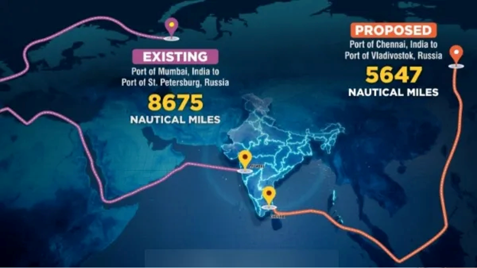
- The Chennai-Vladivostok maritime trade route is a significant and strategic sea link connecting southern India to the Russian Far East.
- The route spans the Bay of Bengal, passing through the Andaman Sea and reaching the Sea of Japan.
- It connects Chennai, a major port city on the southeastern coast of India, to Vladivostok, Russia’s primary port on the Pacific Ocean.
- The route goes through the Malacca Strait, one of the busiest and most important shipping lanes in the world.
- It traverses the East Asian seas and connects major international shipping hubs.
- The route covers 5,600 nautical miles, reducing transport time between Indian and Russian ports by up to 16 days, from over 40 days to 24 days.
Importance of the Chennai-Vladivostok Maritime Trade Route
- Enhances trade between India and Russia, particularly in sectors such as energy, defense, and technology.
- Promotes economic cooperation between Russia and other East Asian nations.
- Reduces travel time compared to traditional European routes, boosting efficiency and lowering shipping costs.
- Strengthens India’s maritime presence in the Indo-Pacific region, reinforcing its geopolitical and economic influence.
Other Key Maritime Trade Routes from India
- India-Gulf Route: Links Indian ports to the Middle East.
- India-East Asia Route: Connects India to Southeast Asian nations.
- India-Europe Route: Passes through the Suez Canal, connecting India to Europe.
|
UPSC CSE PYQ Q1. Which of the following was a very important seaport in the Kakatiya Kingdom? (2017)
Answer: Option B Q2. Consider the following pairs:
Which of the above pairs is/are correctly matched? (2014)
Answer: Option A |


World’s First Baby Treated with Personalized CRISPR Gene Editing
China’s 1st Attempt To Survey And Sample an Asteroid : China’s Space Mission Tianwen-2
India Assumes Chairmanship of Asian Productivity Organisation (APO) – 2025-26
Karol Bagh Metro Pillar No. 112, Above Domino's, 22B, First Floor, New Delhi - 110060
Very Important Instruction For Any Issue, Student Must Produce His/Her Fee Receipt. Without Fee Receipt, It Will Not Be Possible To Track Your Details. If You Have Been Given Any Special Consideration, You Must Keep That In Writing And Produce In Case Of Conflict.
Copyright © 2024-2026 ENSURE IAS. All rights reserved.