- Courses
- GS Full Course 1 Year
- GS Full Course 2 Year
- GS Full Course 3 Year
- GS Full Course Till Selection
- MEP (Mains Enrichment Programme) Data, Facts
- Essay Target – 150+ Marks
- Online Program
- GS Recorded Course
- NCERT- First Ladder
- Polity
- Geography
- Economy
- Ancient, Medieval and Art & Culture AMAC
- Modern India, Post Independence & World History
- Environment
- Governance
- Science & Technology
- International Relations and Internal Security
- Disaster Management
- Ethics
- Current Affairs
- Indian Society and Social Issue
- CSAT
- 5 LAYERED ARJUNA Mentorship
- Public Administration Optional
- ABOUT US
- OUR TOPPERS
- TEST SERIES
- FREE STUDY MATERIAL
- VIDEOS
- CONTACT US
How remote sensing system LiDAR helped discover a lost Mayan city
How remote sensing system LiDAR helped discover a lost Mayan city
- In November 2024, A vast ancient Maya city, complete with palaces and pyramids, has been discovered in a dense jungle in Mexico
- This remarkable discovery was made possible through the use of LiDAR technology.
What is LiDAR?
- LiDAR stands for Light Detection and Ranging.
- It is a type of remote sensing technology that uses light in the form of laser pulses to measure distances from a sensor (usually on an aircraft) to the Earth’s surface.
- Functionality: LiDAR can create highly detailed 3D maps of the ground, with an accuracy of up to 10 centimeters, as reported by the US Geological Survey.
How LiDAR Works
-
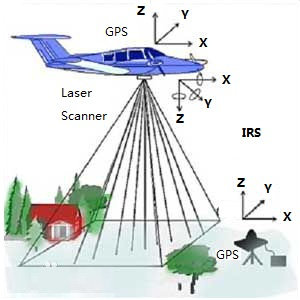
Key Components: A LiDAR system consists of:
- A laser that emits light pulses.
- A scanner that captures the reflected light.
- A GPS receiver that provides precise location data.
-
The Process:
- The laser sends out rapid pulses of light toward the ground.
- When the light hits the surface (like trees, buildings, or land), some of it reflects back to the sensor.
- The LiDAR system measures the time it takes for the light to return, allowing it to calculate how far away the ground is.
-
Data Collection:
- The data collected initially forms a "point cloud," which includes numerous points that represent the various surfaces on the Earth.
- Each point can reveal details about what the light hit, allowing researchers to differentiate between features like trees and structures.
-
Refining the Data:
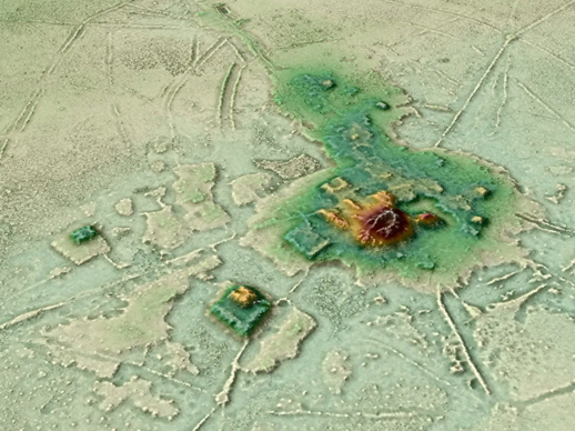
- Scientists can process the point cloud data to create what’s known as a “bare earth” Digital Elevation Model.
- This model shows the ground surface without any vegetation or buildings, making it easier to identify hidden structures.
Why LiDAR is Useful for Archaeology?
- LiDAR provides precise, 3-dimensional information about the Earth’s shape and surface features.
- This data is valuable not only for geographers and engineers but has become increasingly important for archaeologists.
- Efficiency:
- Traditional archaeological work often involved labor-intensive methods, where researchers had to walk through dense vegetation, clearing paths to find potential sites.
- This could take a long time and require a lot of effort.
- LiDAR changes this by allowing researchers to analyze large areas quickly and from a distance, making it much easier to identify sites of interest.
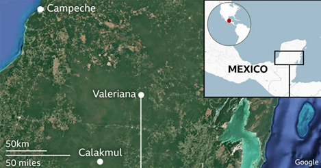
The Discovery of Valeriana:
- The lead researcher in this recent study used publicly available LiDAR data collected in 2013 as part of a forest monitoring project.
- This data helped them identify the previously unknown city, which they named Valeriana.
- Key Features of Valeriana:
- The city includes several important characteristics of a Classic Maya political center:
- Enclosed plazas connected by wide pathways.
- Temple pyramids that serve as important ceremonial structures.
- A ballcourt for games that were significant in Maya culture.
- A reservoir, which was likely created by damming a seasonal watercourse, providing water for the inhabitants.
- The city includes several important characteristics of a Classic Maya political center:
- The researchers believe this city dates back to before 150 CE, marking it as an important site in Maya history.
Future Implications:
- The researcher hopes that discovering Valeriana will lead to more findings about hidden Mayan cities and settlements.
- Interestingly, this city is situated near a major highway and close to a town where people have been farming for years.
- Despite this proximity, it was unknown to both the local government and the scientific community until now.
- This discovery emphasizes the potential for using LiDAR technology to uncover more of the ancient Maya civilization, suggesting that there are still many hidden sites waiting to be discovered.
Conclusion
The discovery of the lost Mayan city Valeriana showcases how LiDAR technology can transform archaeological research. By revealing hidden structures beneath thick vegetation, LiDAR allows researchers to explore and understand the rich history of ancient civilizations like the Maya. As more studies utilize this technology, we can expect to uncover even more about our past and the remarkable societies that once thrived.

Must Check: Best IAS Coaching In Delhi
UPSC Prelims Result 2024 Out: Expected Cut Off & Other Details, UPSC Prelims 2024 Answer with Explanation, Daily Prelims Quiz, Daily Current Affairs, MONTHLY CURRENT AFFAIRS TOTAL (CAT) MAGAZINE, Best IAS Coaching Institute in Karol Bagh, Best IAS Coaching Institute in Delhi, Daily Mains Question Answer Practice, ENSURE IAS UPSC Toppers, UPSC Toppers Marksheet, Previous Year Interview Questions, UPSC Syllabus

India-UK Ties Deepen: From Trade to Terror Fight
India’s EV Mission: Progress Delayed, Not Denied

Delays And Problems Are Hurting Ayushman Bharat In Jharkhand
Karol Bagh Metro Pillar No. 112, Above Domino's, 22B, First Floor, New Delhi - 110060
Very Important Instruction For Any Issue, Student Must Produce His/Her Fee Receipt. Without Fee Receipt, It Will Not Be Possible To Track Your Details. If You Have Been Given Any Special Consideration, You Must Keep That In Writing And Produce In Case Of Conflict.
Copyright © 2024-2026 ENSURE IAS. All rights reserved.