- Courses
- GS Full Course 1 Year
- GS Full Course 2 Year
- GS Full Course 3 Year
- GS Full Course Till Selection
- Online Program
- GS Recorded Course
- NCERT (Recorded 500+ Hours)
- Polity Recorded Course
- Geography Recorded Course
- Economy Recorded Course
- AMAC Recorded Course
- Modern India, Post Independence & World History
- Environment Recoded Course
- Governance Recoded Course
- Science & Tech. Recoded Course
- International Relations and Internal Security Recorded Course
- Disaster Management Module Course
- Ethics Recoded Course
- Essay Recoded Course
- Current Affairs Recoded Course
- CSAT
- 5 LAYERED ARJUNA Mentorship
- Public Administration Optional
- ABOUT US
- OUR TOPPERS
- TEST SERIES
- FREE STUDY MATERIAL
- VIDEOS
- CONTACT US
Helicopter Navigation with GAGAN Satellite Technology
Helicopter Navigation with GAGAN Satellite Technology
Latest Context
By conducting Asia's first demonstration of performance-based navigation for helicopters, India achieved a significant milestone in the aviation sector. It utilised the state-of-the-art GAGAN satellite technology. The flight took off from Juhu in Mumbai to Pune.
Performance-Based Navigation (PBN): It is a new concept of air navigation which permits an aircraft to fly exactly as per the predetermined route using advanced onboard navigation systems and satellite signals. PBN increases the efficiency, safety, and capacity of air traffic management by decreasing the reliance on ground-based navigation support and permitting more flexible flight paths.
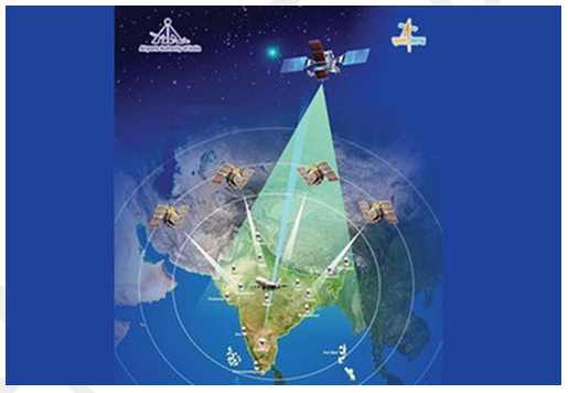
GAGAN Satellite Technology
- Introduction: GAGAN is the acronym used for GPS Aided GEO Augmented Navigation. Indian Space Research Organisation (ISRO) and the Airports Authority of India (AAI) jointly developed this technology which is a space-based augmentation system.
- Features
- It enhances its accuracy up to a higher level corresponding to the output of GPS navigation by providing local geographical positioning which in turn, improves the precision of aircraft location for more efficient traffic management.
- It increases the exactness and integrity of the GPS signals by rectifying the mistakes caused by atmospheric disturbances, orbital deviations, and clock drifts.
- It also supports aircraft/helicopters’ guided landing at airports which do not have instrument landing systems for low-visibility operations.
Benefits:
-
Improved efficiency: GAGAN enables more efficient use of airspace and fuel, resulting in lower emissions and operational costs by permitting optimal flight paths and reduced separation standards.
-
Enhanced safety: GAGAN reduces the risk of collisions, human errors, terrain strikes, and controlled flight into terrain (CFIT) accidents by providing accurate and reliable navigation information. In addition, it also enhances situational awareness and emergency response capabilities for pilots and air traffic controllers.
-
Increased capacity: GAGAN increases the capacity and connectivity of the aviation network by increasing the number of flights that can be accommodated in a given airspace. It also improves its access to remote and underserved areas that lack conventional navigation infrastructure or have challenging terrain. Furthermore, GAGAN will offer benefits beyond aviation to all modes of transportation, comprising highways, maritime, and railroads.
![]()
Q.1 Which one of the following countries has its own Satellite Navigation System? (2023)
a. Australia
b. Canada
c. Israel
d. Japan
Ans: (d)
Q.2 With reference to the Indian Regional Navigation Satellite System (IRNSS), consider the following statements: (2018)
1. IRNSS has three satellites in geostationary and four satellites in geosynchronous orbits.
2. IRNSS covers entire India and about 5500 sq. Km beyond its borders.
3. India will have its own satellite navigation system with full global coverage by the middle of 2019.
Which of the statements given above is/are correct?
(a) 1 only
(b) 1 and 2 only
(c) 2 and 3 only
(d) None
Ans: (a)
Mains
Q.1 Why is Indian Regional Navigational Satellite System (IRNSS) needed? How does it help in navigation? (2018)
Must Check: Best IAS Coaching Centre In Delhi

World’s First Baby Treated with Personalized CRISPR Gene Editing
China’s 1st Attempt To Survey And Sample an Asteroid : China’s Space Mission Tianwen-2

India Assumes Chairmanship of Asian Productivity Organisation (APO) – 2025-26
Karol Bagh Metro Pillar No. 112, Above Domino's, 22B, First Floor, New Delhi - 110060
Very Important Instruction For Any Issue, Student Must Produce His/Her Fee Receipt. Without Fee Receipt, It Will Not Be Possible To Track Your Details. If You Have Been Given Any Special Consideration, You Must Keep That In Writing And Produce In Case Of Conflict.
Copyright © 2024-2026 ENSURE IAS. All rights reserved.