- Courses
- GS Full Course 1 Year
- GS Full Course 2 Year
- GS Full Course 3 Year
- GS Full Course Till Selection
- Answer Alpha: Mains 2025 Mentorship
- MEP (Mains Enrichment Programme) Data, Facts
- Essay Target – 150+ Marks
- Online Program
- GS Recorded Course
- Polity
- Geography
- Economy
- Ancient, Medieval and Art & Culture AMAC
- Modern India, Post Independence & World History
- Environment
- Governance
- Science & Technology
- International Relations and Internal Security
- Disaster Management
- Ethics
- NCERT Current Affairs
- Indian Society and Social Issue
- NCERT- Science and Technology
- NCERT - Geography
- NCERT - Ancient History
- NCERT- World History
- NCERT Modern History
- CSAT
- 5 LAYERED ARJUNA Mentorship
- Public Administration Optional
- ABOUT US
- OUR TOPPERS
- TEST SERIES
- FREE STUDY MATERIAL
- VIDEOS
- CONTACT US
PLACES IN NEWS 1st APRIL 2025
PLACES IN NEWS 1st APRIL 2025
01-04-2025

Bodh Gaya Temple
Why in news?
- Since February 2024, Buddhist monks under the All India Buddhist Forum (AIBF) have been protesting, demanding the repeal of the Bodh Gaya Temple Act (BTA), 1949.
About Bodh Gaya Temple:
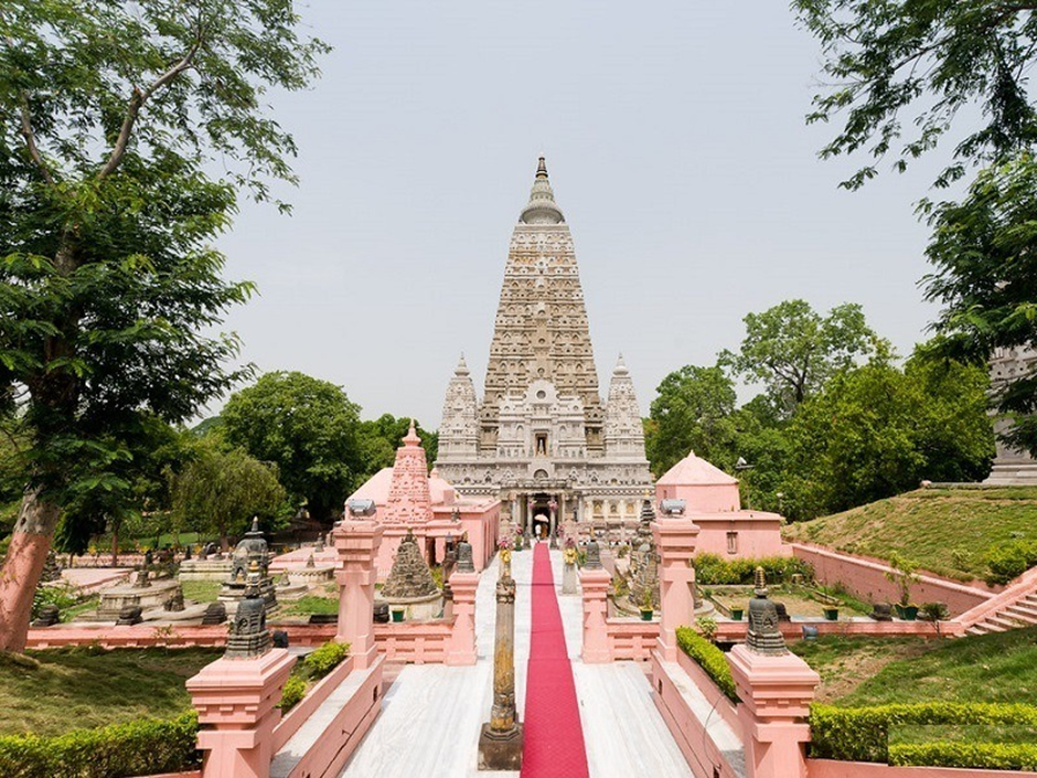
- Location:
- The Bodh Gaya Temple is located in Bodh Gaya, Bihar, India, on the banks of the Niranjana River.
- It is one of the four most sacred Buddhist sites, along with Lumbini (Buddha’s birthplace), Sarnath (Buddha’s first sermon), and Kushinagar (Buddha’s parinirvana).
- Establishment and Historical Significance:
- Emperor Ashoka built the original temple in the 3rd century BCE, marking the site where Gautama Buddha attained enlightenment under the Bodhi Tree.
- The present structure dates to the 5th–6th centuries CE and is one of the oldest surviving brick structures in India.
- Over centuries, the temple remained a centre of Buddhist learning, especially during the Pala Dynasty, but declined after Bakhtiyar Khilji’s invasion in the 13th century.
- In 1590, a Hindu monk established the Bodh Gaya Mutt, leading to Hindu control over the temple.
- The British-era records continued to refer to Bodh Gaya as a Hindu-controlled site until India’s independence.
- The temple complex was designated a UNESCO World Heritage Site in 2002.
- Architectural Features:
- Grand Temple: A 50-metre-high pyramidal shikhara (tower) with intricate carvings and motifs.
- Four smaller towers surround the main temple, each topped with an umbrella-like dome.
- Sacred Bodhi Tree: Believed to be a direct descendant of the original tree under which Buddha attained enlightenment.
- Vajrasana (Diamond Throne): A stone slab marking the exact meditation spot of Buddha.
- Temple Shrine: Houses a yellow sandstone statue of Buddha, encased in glass.
- The 4.8-hectare complex includes ancient shrines and modern Buddhist structures built by devotees.
- The Bodh Gaya Temple Act (BTA), 1949:
- Passed by the Bihar Assembly, the Act aimed to formalise temple management, transferring control to a management committee instead of a single Hindu authority.
- The Act established an eight-member management committee with equal representation for Hindus and Buddhists, but the District Magistrate (DM) was made the ex-officio chairperson.
- Historically, since the DM was often a Hindu, it created a perceived Hindu majority in temple administration.
- Protests Against the Act:
- Buddhist organisations, including the All India Buddhist Forum (AIBF), have long demanded full control over the temple, calling it Bodh Gaya Mahavihara.
- Since February 2024, Buddhist monks have been protesting, seeking repeal of the BTA, 1949, arguing that the temple should be administered solely by Buddhists.
- In the early 1990s, Bihar CM Lalu Prasad Yadav draughted the Bodh Gaya Mahavihara Bill to transfer temple management to Buddhists, but the bill was never passed.
- The 2013 amendment allowed the ex-officio chairman (DM) to be from any faith, but Buddhist groups continue to demand full control.
Karimpuzha Wildlife Sanctuary
Why in news?
- A Forest Department survey discovered 63 new species of odonates, butterflies, and birds in Karimpuzha Wildlife Sanctuary.
About Karimpuzha Wildlife Sanctuary:
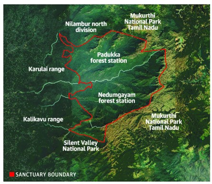
- Geography:
- Karimpuzha Wildlife Sanctuary is located in the Malappuram district of Kerala, spanning 227.97 sq. km on the western slopes of the Nilgiri Hills.
- It forms part of the Nilgiri Biosphere Reserve (NBR), recognised under UNESCO’s Man and Biosphere Programme.
- The sanctuary shares its boundary with Mukurthi National Park (Tamil Nadu) to the east and Silent Valley National Park (Kerala) to the south.
- The Karimpuzha River, a tributary of the Chaliyar River, flows through the sanctuary, contributing to its rich biodiversity.
- The landscape includes steep hills, deep valleys, marshlands, grasslands, and shola forests, with altitudes ranging from 40 m to 2550 m, creating diverse habitats.
- Flora and Fauna:
- The sanctuary is unique as it hosts all seven forest types found in Kerala, including evergreen rainforest, semi-evergreen forest, moist deciduous forest, sub-tropical hill forest, montane wet grasslands, and montane wet temperate forest.
- It is home to endemic species of the Western Ghats, such as the Nilgiri Tahr, Lion-tailed Macaque, Slender Loris, Tiger, and Gaur.
- The sanctuary supports nomadic Cholanaikan tribes, classified as Particularly Vulnerable Tribal Groups (PVTGs) by the Government of India.
- The diverse ecosystem, coupled with perennial water sources, makes it an ideal habitat for a wide variety of species, including newly recorded odonates, butterflies, and birds.
Tonga
Why in news?
- A powerful 7.1 magnitude earthquake struck near Tonga, triggering a tsunami warning for the region.
About Tonga:
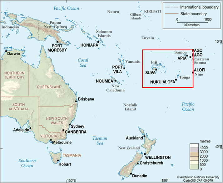
- Location:
- Tonga, officially the Kingdom of Tonga, is an archipelago of 169 islands, with only 36 inhabited.
- It is located in the South Pacific Ocean, south of Samoa, east of Fiji, and just north of the Tropic of Capricorn.
- The three largest islands are Tongatapu, Ha'apai, and Vava'u, with Nuku‘alofa as the capital on Tongatapu.
- Geophysical Characteristics:
- Tonga’s western islands are volcanic, with four active volcanoes, while its eastern islands are low-lying coral formations.
- The nation is part of the Pacific Ring of Fire, a seismically active region prone to earthquakes and volcanic eruptions.
- Due to its tectonic setting, Tonga frequently experiences seismic activity, tsunamis, and volcanic eruptions.
- Reason Behind the Earthquake:
- Tonga is located near the Tonga Trench, a subduction zone where the Pacific Plate is forced under the Indo-Australian Plate.
- This subduction results in intense seismic activity, leading to frequent earthquakes and tsunamis.
- The recent 7.1 magnitude earthquake was caused by tectonic stress release along this subduction zone.
- Impact of the Earthquake:
- The earthquake triggered a tsunami warning, raising concerns for coastal communities.
- It caused infrastructure damage and disrupted communication and transportation networks.
- Local authorities advised evacuations in vulnerable areas due to the risk of aftershocks and potential tsunamis.
Netravati River
Why in news?
- Sewage inflow into the Netravati River in Mangaluru has raised environmental concerns, highlighting ongoing water pollution issues and ecosystem threats.
About Netravati River:
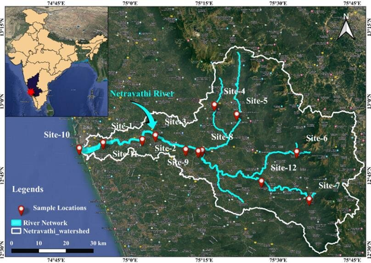
- Origin and Course:
- The Netravati River originates in the Bangrabalige Valley, Yelaneeru Ghat, in the Kudremukha range of Chikkamagaluru district, Karnataka.
- It flows through Dharmasthala, a famous pilgrimage site, before merging with the Kumaradhara River at Uppinangadi.
- The river ultimately drains into the Arabian Sea, south of Mangalore.
- It covers a drainage area of 1,353 square miles, with over 100 TMC of water flowing annually to the sea.
- Historical and Geographical Significance:
- Earlier known as the Bantwal River, it played a crucial role in the trade and economy of the region.
- The 1855 Gazetteer of Southern India described it as an unfordable river during the South-West Monsoon.
- The riverbed consists of hornblende rock, mica, garnets, and pegmatite fragments.
- It is navigable by small country boats for several miles.
- The river supports agriculture and fishing, providing water for irrigation during non-monsoon periods.
- The riverbed is a source of fine sand used in construction.
- Environmental Concerns:
- Flooding is a recurring problem, with major floods recorded in 1928 and 1974, submerging Bantwal town.
- Several mini hydroelectric and river diversion projects threaten the ecological balance of the region.
- Experts warn that altering the river’s course could impact marine biodiversity and rainforest continuity in the Western Ghats.
- Opposition has risen against hydroelectric projects due to potential environmental damage.
Similipal Biosphere Reserve
Why in news?
-
- A new wild ginger species has been discovered in Odisha's Similipal Biosphere Reserve.
About Similipal Biosphere Reserve:
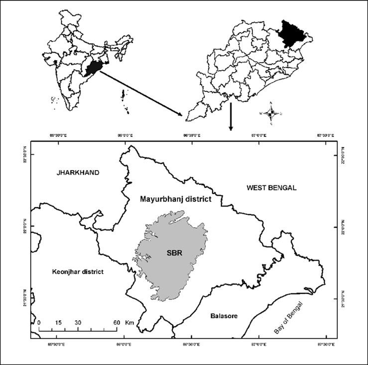
- Location and Geography:
- Similipal Biosphere Reserve is located in the Mayurbhanj district of Odisha, India.
- It covers an area of 5,569 sq. km, with Similipal National Park forming its core.
- The reserve is part of the Eastern Ghats and is characterised by hills, valleys, plateaus, and dense forests.
- Several rivers, like Budhabalanga, Khairi, and Salandi, originate from Similipal, providing water to the region.
- The region experiences a tropical monsoon climate, with heavy rainfall and dense vegetation.
- Flora and Fauna:
- Similipal is home to tropical moist deciduous forests, dry deciduous forests, grasslands, and savannahs.
- It supports over 1,000 species of plants, including medicinal and rare tree species.
- The reserve is famous for its rich biodiversity, including elephants, tigers, leopards, deer, gaur, and wild boars.
- It is also a habitat for mugger crocodiles, reptiles, and over 200 species of birds.
- Recent discoveries, like new wild ginger species, highlight its botanical richness.
- Other Protected Areas within Similipal Biosphere Reserve:
- Similipal National Park: The core area of the biosphere, known for its diverse wildlife and dense forests.
- Hadgarh Wildlife Sanctuary: Located in Keonjhar district, known for its water bodies and bird species.
- Kuldiha Wildlife Sanctuary: Situated in Balasore district, an important corridor for elephants.

|
Also Read |
|
| FREE NIOS Books | |

PLACES IN NEWS 3rd JULY 2025

PLACES IN NEWS 2nd JULY 2025

PLACES IN NEWS 1st JULY 2025
Karol Bagh Metro Pillar No. 112, Above Domino's, 22B, First Floor, New Delhi - 110060
Very Important Instruction For Any Issue, Student Must Produce His/Her Fee Receipt. Without Fee Receipt, It Will Not Be Possible To Track Your Details. If You Have Been Given Any Special Consideration, You Must Keep That In Writing And Produce In Case Of Conflict.
Copyright © 2024-2026 ENSURE IAS. All rights reserved.