- Courses
- GS Full Course 1 Year
- GS Full Course 2 Year
- GS Full Course 3 Year
- GS Full Course Till Selection
- Answer Alpha: Mains 2025 Mentorship
- MEP (Mains Enrichment Programme) Data, Facts
- Essay Target – 150+ Marks
- Online Program
- GS Recorded Course
- Polity
- Geography
- Economy
- Ancient, Medieval and Art & Culture AMAC
- Modern India, Post Independence & World History
- Environment
- Governance
- Science & Technology
- International Relations and Internal Security
- Disaster Management
- Ethics
- NCERT Current Affairs
- Indian Society and Social Issue
- NCERT- Science and Technology
- NCERT - Geography
- NCERT - Ancient History
- NCERT- World History
- NCERT Modern History
- CSAT
- 5 LAYERED ARJUNA Mentorship
- Public Administration Optional
- ABOUT US
- OUR TOPPERS
- TEST SERIES
- FREE STUDY MATERIAL
- VIDEOS
- CONTACT US
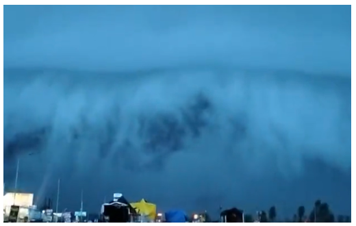
SHELF CLOUDS FORMATION
SHELF CLOUDS FORMATION
14-07-2023
Latest Context
In Haridwar, Uttarakhand, a massive Shelf Cloud formation was recently seen.

Facts about Shelf Clouds
- Shelf clouds - also known as Arcus clouds - are often associated with powerful storm systems, and many times they are reported as wall clouds, funnel clouds, or rotation.
- Sometimes these clouds may be observed behind cumulonimbus clouds, which are dense, vertical, and produce heavy rain.
- They frequently occur before large thunderstorms that produce hail, tornadoes, torrential rain, high winds, and other severe weather.
-
Formation:
- When a cumulonimbus cloud's frigid downdraft hits the ground, it may spread quickly and push already-existing warm, moist air upward.
- When a cumulonimbus cloud's frigid downdraft hits the ground, the cold air may spread quickly and push already-existing warm, moist air upward.
- Warm air is forced upward while the cold air falls, resulting in condensation and cloud formation. This procedure gives a shelf cloud its distinctive horizontal form and look.
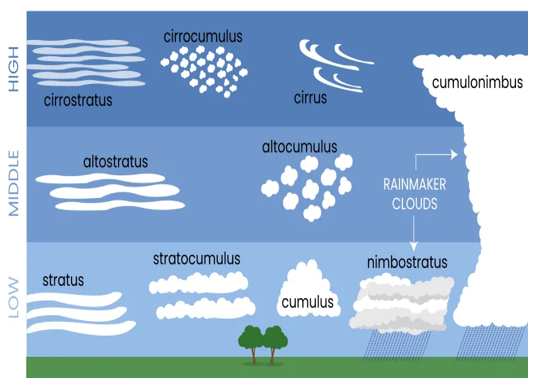
Types of Clouds
-
High Clouds:
- Cirrus Clouds: High-altitude clouds called cirrus have a wispy, feathery, and white appearance. They are made of ice crystals and are frequently related to pleasant weather. A ring around the sun or moon called a halo can be caused by cirrus clouds.
- Cirrocumulus Clouds: clouds at high altitude that resemble white, fluffy, small cloud patches. They frequently have an irregular or honeycomb-like appearance.
- Cirrostratus Clouds: High-altitude clouds that form a thin, whitish veil covering the sky. Around the sun or moon, they can create halos.
-
Middle Clouds:
- Altocumulus Clouds: clouds in mid-levels that appear as white or grey layers or patches. They frequently seem wavy or lumpy.
- Altostratus Clouds: mid-level clouds that create the sky in a consistent coating of grey or bluish-gray. They can produce light precipitation because they are denser and thicker than cirrostratus clouds.
-
Low Clouds:
- Cumulus Clouds: White, fluffy clouds with a flat base and circular tops are known as cumulus clouds. On bright days, you may frequently observe them. They are generally generated by rising warm air currents. When cumulus clouds grow, they might become cumulonimbus clouds, which are connected to thunderstorms.
- Stratus Clouds: Low-level stratus clouds give the sky a uniform coating of greyish colour. They frequently bring drizzle or light precipitation and can give the sky a dull, overcast appearance.
- Stratocumulus Clouds: Low-level clouds that have a patchy appearance and frequently take the form of spherical masses. They might be white or grey and cover a sizable area of the sky.
- Nimbostratus Clouds: clouds that cover the sky and are thick, dark, and featureless. Continuous precipitation that frequently lasts for a long time is brought on by them.
-
Clouds that exhibit Significant Vertical Development:
- Cumulonimbus Clouds: Thunderstorms are often linked with huge, towering clouds. They have a dark base and may ascend to great heights, bringing with them torrential rain, lightning, and powerful winds.
Must Check: IAS Coaching Centre In Delhi

India's AI Future Needs Strategy First

Zero Police Convictions in Custodial Deaths

Restructuring Global Development Finance
Karol Bagh Metro Pillar No. 112, Above Domino's, 22B, First Floor, New Delhi - 110060
Very Important Instruction For Any Issue, Student Must Produce His/Her Fee Receipt. Without Fee Receipt, It Will Not Be Possible To Track Your Details. If You Have Been Given Any Special Consideration, You Must Keep That In Writing And Produce In Case Of Conflict.
Copyright © 2024-2026 ENSURE IAS. All rights reserved.