- Courses
- GS Full Course 1 Year
- GS Full Course 2 Year
- GS Full Course 3 Year
- GS Full Course Till Selection
- Answer Alpha: Mains 2025 Mentorship
- MEP (Mains Enrichment Programme) Data, Facts
- Essay Target – 150+ Marks
- Online Program
- GS Recorded Course
- Polity
- Geography
- Economy
- Ancient, Medieval and Art & Culture AMAC
- Modern India, Post Independence & World History
- Environment
- Governance
- Science & Technology
- International Relations and Internal Security
- Disaster Management
- Ethics
- NCERT Current Affairs
- Indian Society and Social Issue
- NCERT- Science and Technology
- NCERT - Geography
- NCERT - Ancient History
- NCERT- World History
- NCERT Modern History
- CSAT
- 5 LAYERED ARJUNA Mentorship
- Public Administration Optional
- ABOUT US
- OUR TOPPERS
- TEST SERIES
- FREE STUDY MATERIAL
- VIDEOS
- CONTACT US
PLACES IN NEWS 3rd JULY 2025
PLACES IN NEWS 3rd JULY 2025
03-07-2025
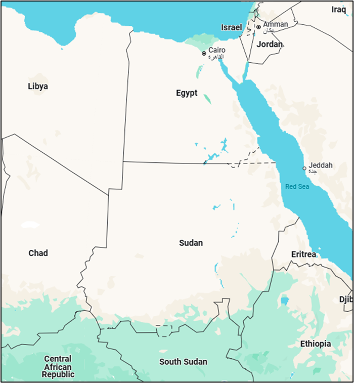
1. SUDAN
Why in the News?
- Millions of people are suffering because of the war in Sudan.
- The United Nations World Food Programme (WFP) has warned that food aid is running out. If help does not come soon, many people may face hunger and even famine.
- A UN meeting is happening in Spain this week to ask countries for more help.
What are the Key Highlights?
- Sudan, officially the Republic of Sudan, is located in Northeast Africa.
- Geographical Coordinates and Borders:
- Coordinates: Approximately centered at 15°N, 30°E.
- Borders:
- North: Egypt
- Northeast: Borders the Red Sea
- East: Eritrea and Ethiopia
- South: South Sudan
- Southwest: Central African Republic
- West: Chad
- Northwest: Libya
- Area: Approximately 1,861,484 km², making it the 15th largest country in the world by land area.
- Coastline: Sudan has a Red Sea coast (providing a coastline of about 853 km)
- Topography and Physical Features:
- Landscape: Sudan features diverse terrain:
- Deserts: The Nubian Desert in the northeast and parts of the Sahara Desert in the northwest dominate much of the country.
- Nile River: The White Nile and Blue Nile converge in Khartoum, the capital, forming the main Nile River, which is a lifeline for agriculture and settlement.
- Mountains: The Nuba Mountains in the south-central region and the Jebel Marra plateau in Darfur (western Sudan) are significant highland areas.
- Savanna and Grasslands: Southern and western regions transition into savanna, supporting agriculture and pastoralism.
- Landscape: Sudan features diverse terrain:
- Highest Point: Mount Kinyeti (3,187 meters) in the Imatong Mountains, though this is now in South Sudan after the 2011 split.
- Climate: Predominantly arid and semi-arid, with tropical climates in the south. Rainfall varies from nearly zero in the northern deserts to 500–1,000 mm annually in the south.
- Political and Administrative Divisions:
- Capital: Khartoum (though Giza has served as a temporary administrative capital during recent conflicts).
- States: Sudan is divided into 18 states (wilayat), including Khartoum, North Kordofan, South Darfur, and Red Sea, among others.
- Population and Demographics:
- Population: Approximately 47 million (based on recent estimates).
- Ethnic Groups: Diverse, including Sudanese Arabs, Nubians, Beja, Fur, Zaghawa, and others.
- Languages: Arabic (official), English (co-official), and numerous indigenous languages like Nubian, Beja, and Fur.
- Religion: Predominantly Sunni Islam, with small Christian and animist minorities.
- History and Political Context:
- Historical Background: Sudan was under Anglo-Egyptian rule until gaining independence in 1956.
- It has faced internal conflicts, notably the Darfur conflict and the civil war that led to South Sudan's secession in 2011.
- Recent Developments:
- Since April 2023, Sudan has been embroiled in a civil war between the Sudanese Armed Forces (SAF) and the Rapid Support Forces (RSF), causing widespread displacement and a humanitarian crisis.
- Over 7.7 million people have been displaced, with 2.2 million fleeing to neighboring countries like Chad and Egypt.
- Economy
- Main Sectors: Agriculture (cotton, sorghum, millet), oil (though production declined after South Sudan’s secession), and livestock.
- Challenges: Economic instability due to conflict, sanctions, and reliance on agriculture in a largely arid environment.
- Currency: Sudanese Pound (SDG).
- Humanitarian Situation:
- Crisis: The ongoing conflict has led to severe food insecurity, with millions facing famine risks. Infrastructure, including hospitals and schools, has been heavily damaged.
- Refugees: Sudan hosts refugees from neighboring countries (e.g., Ethiopia, Eritrea) while also producing millions of internally displaced persons (IDPs) and refugees.
- Cultural and Historical Significance
- Archaeological Sites: Sudan is home to ancient Nubian and Kushite civilizations, with UNESCO sites like the Pyramids of Meroë and Jebel Barkal.
- Cultural Diversity: A blend of Arab, African, and indigenous traditions shapes Sudan’s music, dance, and cuisine.
- Geopolitical Importance:
- Strategic Location: Sudan’s Red Sea coast makes it a key player in regional trade and geopolitics, with Port Sudan serving as a vital hub.
- Regional Influence: Sudan is a member of the African Union, Arab League, and Organization of Islamic Cooperation, though its role has been limited by internal instability.
- Environmental Challenges:
- Desertification: Northern regions face encroaching desertification due to climate change.
- Water Resources: Dependence on the Nile River creates tensions with downstream countries like Egypt over water rights (e.g., disputes over Ethiopia’s Grand Ethiopian Renaissance Dam).
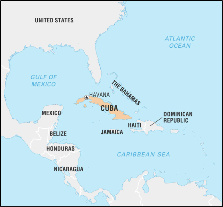
2. CUBA
Why in the News?
- Cuba is going through a very tough time. There are serious shortages of food, fuel, and medicines. People face long power cuts, and many parts of the country do not have working factories or services.
- In the past, Cuba often got help from Russia. But now, many of Russia’s promises have not been fulfilled.
- Instead, China has quietly started helping Cuba in important ways. In 2025, China is building 55 solar power plants in Cuba. One of them, a 21 MW solar park, has already started working near a small town called Jatibonico.
- This shows that China is becoming a strong partner for Cuba, especially through its Belt and Road Initiative.
What are the Key Highlights?
- Cuba, officially known as the Republic of Cuba, is an island nation located in the Caribbean, at the intersection of the Gulf of Mexico, the Caribbean Sea, and the Atlantic Ocean.
- Geographical Coordinates and Location:
- Coordinates: Approximately 21.5°N latitude and 80°W longitude.
- Bordering Nations of Cuba:
- North: United States (Florida): Approximately 150 km (90 miles) across the Straits of Florida. The closest point is between Key West, Florida, and Havana, Cuba.
- West: Mexico: The Yucatán Peninsula is about 210 km (130 miles) from Cuba’s western tip across the Yucatán Channel.
- South: Jamaica: Roughly 140 km (87 miles) south of Cuba’s southern coast across the Caribbean Sea.
- Cayman Islands (United Kingdom territory): Approximately 150 km (93 miles) southwest of Cuba.
- East:
- Haiti: About 77 km (48 miles) east of Cuba’s eastern tip (near Guantanamo Bay) across the Windward Passage.
- Dominican Republic: Further east, beyond Haiti, sharing maritime boundaries indirectly via the Caribbean Sea.
- Northeast:
- The Bahamas: Approximately 100 km (62 miles) north of Cuba’s northern coast, particularly near the eastern provinces.
- Area: Total land area of approximately 109,884 km², including the main island and smaller islets like the Isle of Youth (Isla de la Juventud).
- Coastline: About 5,746 km, with numerous beaches, bays, and coral reefs.
- Topography and Physical Features:
- Landscape:
- Main Island: The island of Cuba is long and narrow, stretching about 1,250 km east to west and 191 km at its widest point.
- Mountains: The Sierra Maestra in the southeast is the highest range, with Pico Turquino (1,974 meters) as the highest peak.
- Other ranges include the Sierra de los Órganos in the west and the Escambray Mountains in the central region.
- Plains and Valleys: Fertile plains, such as the Cauto River Valley, support agriculture (e.g., sugarcane, tobacco).
- Coastal Features: Cuba has over 200 bays and 289 beaches, with notable areas like Varadero Beach and the Zapata Peninsula (a UNESCO Biosphere Reserve).
- Climate:
- Tropical, with a wet season (May–October) and a dry season (November–April).
- Average temperatures range from 21°C (70°F) in winter to 27°C (81°F) in summer.
- Cuba is prone to hurricanes, especially from August to November.
- Rivers: The Cauto River (343 km) is the longest, flowing through the eastern provinces.
- Landscape:
- Political and Administrative Divisions:
- Capital: Havana (La Habana), the largest city and economic hub.
- Provinces: Cuba is divided into 15 provinces and one special municipality (Isle of Youth).
- Key provinces include Havana, Santiago de Cuba, and Pinar del Río.
- Population and Demographics:
- Population: Approximately 11.2 million (based on recent estimates).
- Languages: Spanish (official).
- Religion: Predominantly Christian (Catholic and Protestant), with Afro-Cuban religions like Santería widely practiced.
- Cultural Significance:
- Cultural Heritage: Cuba is known for its vibrant music (salsa, son, rumba), dance (mambo, cha-cha), and literature.
- Landmarks: Old Havana (UNESCO site), Viñales Valley (UNESCO site), and the Che Guevara Mausoleum in Santa Clara.
- Cuisine: Features dishes like ropa vieja, arroz con pollo, and mojitos.
- Economy Main Sectors:
- Agriculture: Sugarcane, tobacco, coffee, and citrus fruits.
- Tourism: A major revenue source, with attractions like Havana’s historic district (a UNESCO World Heritage Site) and Varadero’s beaches.
- Other Industries: Biotechnology, pharmaceuticals, and nickel mining (Cuba has one of the world’s largest nickel reserves).
- Environmental Issues:
- Environmental Challenges: Deforestation, soil degradation, and vulnerability to hurricanes and climate change (e.g., rising sea levels threaten coastal areas).

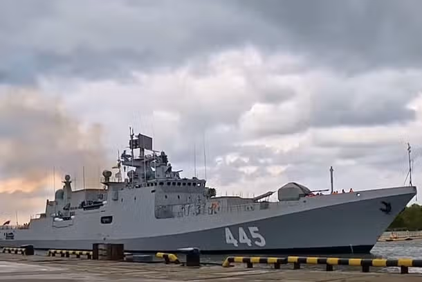
Sailing into Self-Reliance: The Legacy of INS Tamal
Socialism and Secularism: Foundational Pillars of the Indian Constitution
Forest Clearance for Puri Airport Deferred Over Wildlife Concerns
Karol Bagh Metro Pillar No. 112, Above Domino's, 22B, First Floor, New Delhi - 110060
Very Important Instruction For Any Issue, Student Must Produce His/Her Fee Receipt. Without Fee Receipt, It Will Not Be Possible To Track Your Details. If You Have Been Given Any Special Consideration, You Must Keep That In Writing And Produce In Case Of Conflict.
Copyright © 2024-2026 ENSURE IAS. All rights reserved.