- Courses
- GS Full Course 1 Year
- GS Full Course 2 Year
- GS Full Course 3 Year
- GS Full Course Till Selection
- Answer Alpha: Mains 2025 Mentorship
- MEP (Mains Enrichment Programme) Data, Facts
- Essay Target – 150+ Marks
- Online Program
- GS Recorded Course
- Polity
- Geography
- Economy
- Ancient, Medieval and Art & Culture AMAC
- Modern India, Post Independence & World History
- Environment
- Governance
- Science & Technology
- International Relations and Internal Security
- Disaster Management
- Ethics
- NCERT Current Affairs
- Indian Society and Social Issue
- NCERT- Science and Technology
- NCERT - Geography
- NCERT - Ancient History
- NCERT- World History
- NCERT Modern History
- CSAT
- 5 LAYERED ARJUNA Mentorship
- Public Administration Optional
- ABOUT US
- OUR TOPPERS
- TEST SERIES
- FREE STUDY MATERIAL
- VIDEOS
- CONTACT US
PLACES IN NEWS 21st MARCH 2025
PLACES IN NEWS 21st MARCH 2025

Türkiye
Why in news?
- Ekrem İmamoğlu, Istanbul’s opposition mayor, was arrested amid rising political tensions in Türkiye. His detention sparked mass protests, reflecting broader concerns over democracy and President Erdoğan’s crackdown on political rivals.
About Türkiye:
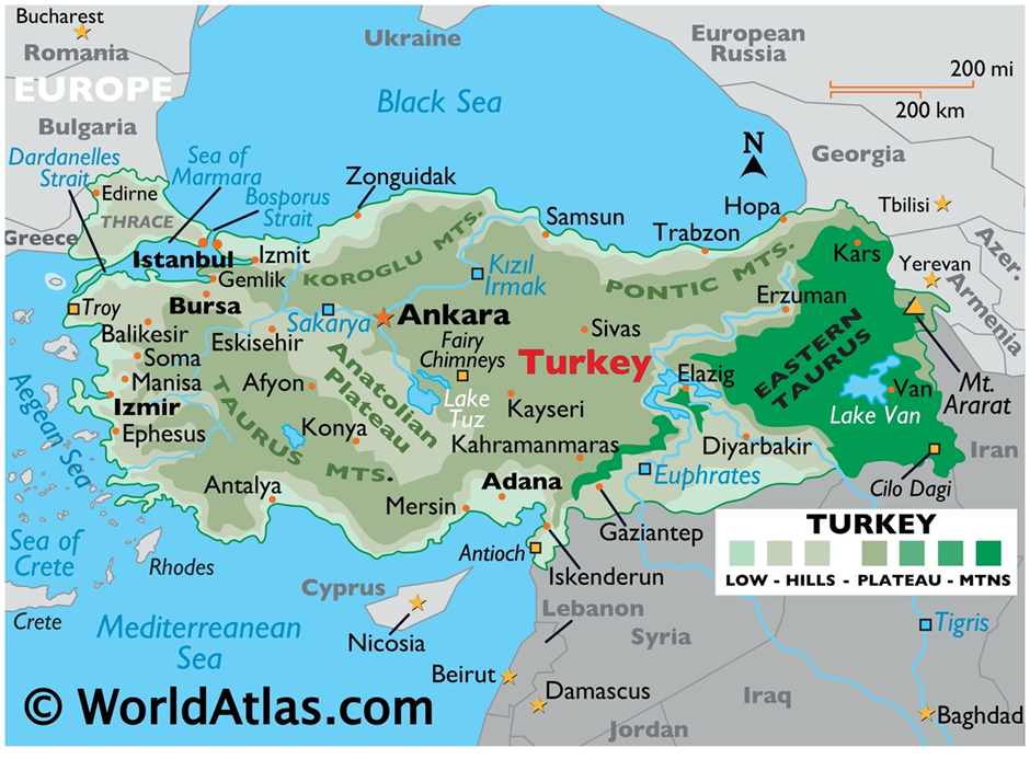
- Location and Geography:
- Türkiye is a transcontinental country located mainly in Anatolia (Asia) and partially in Thrace (Europe). It shares borders with Greece, Bulgaria, Georgia, Armenia, Iran, Iraq, and Syria, with the Mediterranean, Aegean, and Black Seas surrounding it.
- The country's diverse terrain includes coastal plains, plateaus, and mountain ranges such as the Taurus and Pontic Mountains. The Anatolian Plateau dominates the interior, providing a mix of arid and fertile lands.
- Major rivers like the Tigris and Euphrates flow through Türkiye, influencing its agriculture and settlement patterns.
- Türkiye experiences varied climatic conditions—Mediterranean climate along the coast, continental climate in the interior, and oceanic conditions in the Black Sea region.
- Recent Civil Protests:
- Thousands of demonstrators flooded Istanbul’s streets following the arrest of Mayor Ekrem İmamoğlu, a key opposition leader and potential challenger to President Recep Tayyip Erdoğan.
- Protesters gathered outside Istanbul’s police headquarters, City Hall, and the Republican People’s Party (CHP) office, denouncing the allegations as unlawful and politically motivated.
- Authorities imposed strict measures, including shutting down roads, restricting social media, and enforcing a four-day demonstration ban, but protests persisted.
- Riot police blocked access to the Vatan Security Department, where İmamoğlu was detained alongside 100 others on charges of corruption, extortion, and alleged links to the PKK.
- Regions Associated with Protests:
- Istanbul, Türkiye’s largest city and economic hub, was the epicentre of protests, particularly in Taksim Square, City Hall, and CHP offices.
- Other major cities, including Ankara and Izmir, also saw demonstrations as opposition supporters condemned the government’s crackdown on political rivals.
- Kurdish-dominated regions in south-eastern Türkiye have also been sensitive to political crackdowns, as İmamoğlu’s arrest involved alleged links to the PKK.
- The unrest reflects Türkiye’s broader political divide, with opposition strongholds mobilising against Erdoğan’s administration ahead of upcoming elections.
Suhelwa Wildlife Sanctuary
Why in news?
- Uttar Pradesh CM Yogi Adityanath announced renaming Suhelwa Wildlife Sanctuary to Suheldev Sanctuary, honoring King Suheldev’s legacy in India's history.
About Suhelwa Wildlife Sanctuary:
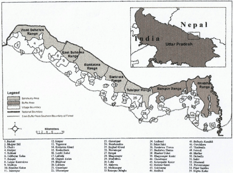
- Location:
- Suhelwa Wildlife Sanctuary is situated in the Shravasti, Balrampur, and Gonda districts of Uttar Pradesh.
- It was formerly part of the Balrampur Estate, owned by the Maharaja of Balrampur before the Zamindari Abolition Act of 1952.
- The sanctuary was officially declared a wildlife sanctuary in 1988.
- The Sohelwa Wildlife Division lies along the Indo-Nepal International Border, making it a vital part of the Bhabar-Tarai Eco-System, known for its rich biodiversity.
- The Tharu tribe, known for their Mongoloid features, has resided in this region for centuries.
- The sanctuary consists of deciduous and semi-evergreen woodlands, creating a diverse habitat for wildlife.
- Flora and Fauna:
- The sanctuary is home to Bahera, Phaldu, Sal, Teak, Dhamina, Jamun, Shisham, Jigna, Haldu, Asna, and Khair trees. These species support the ecosystem by providing food and shelter to various animals and birds.
- Suhelwa Wildlife Sanctuary hosts a variety of wildlife, including tigers, leopards, cheetals, bears, wolves, hares, jackals, wild boars, sambars, monkeys, langurs, pythons, and otters.
- It is also home to numerous bird species such as black partridges, quails, peacocks, kingfishers, bulbuls, mynahs, eagles, nightingales, cuckoos, and owls.
About King Suheldev:
- King Suheldev was a legendary ruler from Shravasti, known for his valiant resistance against Ghaznavid forces.
- He is widely remembered for defeating and killing Ghazi Saiyyad Salar Masud, the general of Mahmud of Ghazni, in the Battle of Bahraich in 1034 CE.
- Suheldev was the eldest son of King Mordhwaj and is mentioned in Persian chronicles like Mirat-i-Masudi, written during the Mughal era.
- His army united local rulers and successfully repelled foreign invaders.
- Though he emerged victorious in battle, Suheldev was later killed by Syed Ibrahim, a commander of Masud.
- His legacy remains significant in Indian history, symbolising Hindu resistance against foreign invasions.
Pulicat Lake
Why in news?
- Worm poaching in Pulicat Lake disrupts the wetland ecosystem, depleting food for birds and fish. Unregulated harvesting threatens biodiversity, endangering migratory birds and impacting local livelihoods dependent on sustainable fishing practices.
About Pulicat Lake:
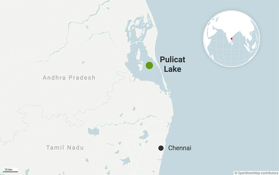
- Location:
- Pulicat Lake is the second-largest brackish water lagoon in India, covering 759 sq km.
- It is situated along the Andhra Pradesh-Tamil Nadu border, with most of it in the Tirupati district, Andhra Pradesh.
- The lake is separated from the Bay of Bengal by Sriharikota Island, which houses the Satish Dhawan Space Centre.
- Major settlements around the lake include Pulicat, Dugarajupatnam, and Sullurpeta.
- The lake receives water from the Arani and Kalangi rivers and is connected to the Buckingham Canal.
- Key Features:
- Pulicat Lake is a vital wetland ecosystem that fluctuates in size with tides and monsoons, spanning 450 sq km during high tide and 250 sq km during low tide.
- It serves as a natural flood buffer, absorbing excess rainwater before draining into the sea.
- The Pulicat Lake Bird Sanctuary, established in 1976, is located within the lagoon, attracting thousands of migratory birds.
- The lake plays a crucial role in local livelihoods, with over 12,000 fishermen depending on its fishery resources.
- Ecological Significance:
- Pulicat Lake is home to a rich variety of flora and fauna. The lake supports commercial fisheries, including prawns, crabs, and mullets, sustaining local economies.
- The bird diversity in Pulicat is remarkable, with species such as flamingos, pelicans, herons, spoonbills, ducks, and kingfishers.
- Every year, around 15,000 flamingos visit the lagoon during migration seasons. The lake’s aquatic vegetation is abundant, supporting diverse fish populations and benthic biodiversity.
- The Sriharikota beaches along the lake are also nesting grounds for endangered sea turtles.
- Worm Poaching in the Region:
- Illegal worm poaching has emerged as a serious ecological threat to Pulicat Lake.
- Fishermen harvest annelid worms, an essential part of the lake’s food chain, for use as bait in commercial fishing.
- The unsustainable extraction of these worms disrupts the lake’s ecosystem, affecting plankton, fish populations, and migratory birds.
- Overharvesting of worms reduces the natural aeration of the lakebed, leading to deoxygenation and increased water pollution.
- It threatens fish reproduction cycles and reduces food availability for migratory birds, ultimately weakening the biodiversity of Pulicat Lake.
- If left unchecked, worm poaching could lead to long-term ecological damage, affecting both wildlife and fishing-dependent communities in the region.
Nigeria
Why in news?
- Nigeria declares a state of emergency in Rivers State as escalating pipeline vandalism causes severe fuel shortages and threatens energy security, prompting urgent government intervention.
About Nigeria:
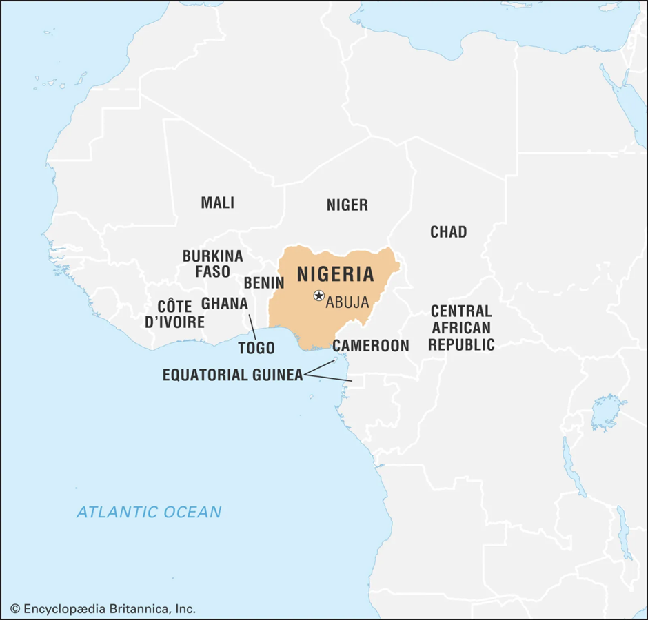
- Location
- Nigeria, located in West Africa, is the most populous country on the continent. It shares land borders with Benin to the west, Niger to the north, Chad to the northeast, and Cameroon to the east.
- The country is bordered by the Atlantic Ocean to the south, with the Gulf of Guinea forming its coastline.
- The Niger River and Benue River are major water bodies that define the country's geography.
- Abuja is Nigeria's capital, while Lagos, the largest city, serves as an economic hub.
- Potential Natural Resources
- Nigeria is rich in natural resources, particularly oil and gas, making it one of the top crude oil producers in Africa.
- The Niger Delta region houses significant petroleum reserves. Other key resources include:
- Natural Gas: Nigeria has the largest gas reserves in Africa, with the potential for LNG exports.
- Solid Minerals: Deposits of gold, limestone, coal, tin, iron ore, lead, and zinc are found in various regions.
- Agricultural Resources: The country produces cocoa, palm oil, groundnuts, rubber, and cotton.
- Renewable Energy Potential: Abundant solar, wind, and hydroelectric energy sources remain underutilized.
- Pipeline Vandalism and Recent Developments
- Pipeline vandalism is a major threat to Nigeria’s oil production and economy. The Niger Delta region, particularly Rivers State, has witnessed frequent attacks on oil infrastructure.
- Criminal groups and militants illegally tap pipelines, causing oil spills, explosions, and economic losses.
- Recently, President Bola Tinubu declared a state of emergency in Rivers State due to increasing pipeline attacks. Key developments include:
- Suspension of the state governor, deputy governor, and lawmakers for alleged inaction.
- Federal takeover of state administration, appointing a retired vice admiral as caretaker.
- Security forces mobilized to address vandalism and restore order.
- Investigation into a Trans Niger Pipeline explosion, which affected crude exports from the Bonny terminal.
- The crisis highlights governance challenges, political instability, and economic risks in Nigeria’s oil sector. Addressing security issues and energy theft remains crucial for stability.
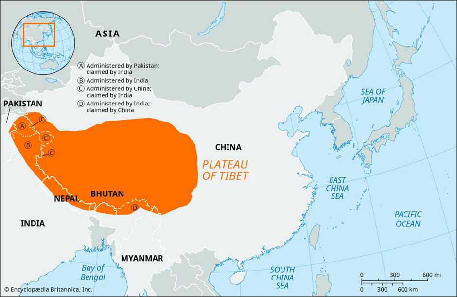
Qinghai-Tibet Plateau
Why in news?
- Recent research by Chinese scientists highlights the significant effects of global climate change over the past 36 years on the lakes of the Qinghai-Tibet Plateau, including expansion, increased water temperature, and greater transparency.
About Qinghai-Tibet Plateau:
-
- Geography and Climate
- Geography and Climate
- The Qinghai-Tibet Plateau, often referred to as the "Roof of the World", is the highest and largest plateau on Earth, covering approximately 2.5 million square kilometres.
- It spans across China, India, Nepal, and Bhutan. The plateau's average elevation exceeds 4,500 meters, making it a unique geographical and ecological region.
- It is home to several major river systems, including the Yangtze, Yellow, Mekong, and Indus Rivers, earning it the title "Asian Water Tower".
- The climate of the plateau is harsh, with long, cold winters and short, cool summers. Temperatures vary significantly between day and night, often dropping below freezing even in summer.
- The plateau experiences a combination of monsoon and westerly wind influences, leading to variable precipitation patterns.
- While some areas receive abundant snowfall, others remain arid, creating diverse ecosystems.
- Formation of the Plateau
- Formation of the Plateau
- The Qinghai-Tibet Plateau was formed around 50 million years ago due to the collision of the Indian and Eurasian tectonic plates.
- This ongoing geological process continues to uplift the region, making it one of the most seismically active zones on Earth.
- The plateau's formation has led to the development of unique landscapes, including high-altitude lakes, glaciers, permafrost regions, and vast grasslands.
- Impact of Climate Change on Plateau Lakes
- Impact of Climate Change on Plateau Lakes
- Recent scientific studies highlight that climate change is significantly altering the lakes of the Qinghai-Tibet Plateau.
- A study published in Nature Reviews Earth & Environment by the Tibetan Plateau Research Institute of the Chinese Academy of Sciences provides critical insights into these changes:
- Expansion of Lakes
- Over the past 36 years, the total area of plateau lakes has expanded by 26%, growing from 37,000 sq km to 47,000 sq km.
- The water volume has increased by 170 cubic kilometres, equivalent to 3.8 times the capacity of the Three Gorges Reservoir.
- Changes in Water Chemistry and Ecology
- Salinity levels have decreased, affecting aquatic biodiversity and ecosystem balance.
- Chlorophyll-a levels, an indicator of primary productivity, have declined, impacting food chains in the lakes.
- Microbial diversity and nutrient content have increased, leading to complex ecological shifts.
- Impact on Regional Climate and Water Security
- Lake expansion has led to increased regional precipitation, affecting local climate patterns.
- The Qinghai-Tibet Plateau's lakes store about 70% of the liquid freshwater in the region, influencing the water supply of major Asian rivers.
- Rising water temperatures have altered carbon exchange patterns, with lakes shifting between carbon sinks and sources.
- Risks to Infrastructure and Livelihoods
- The expansion of lakes poses a threat of overflow and breaching, endangering infrastructure such as the Qinghai-Tibet Railway.
- The potential reduction in salinity could alter carbon cycling, increasing greenhouse gas emissions from the region.
-
- Future Outlook and Mitigation Measures
- Future Outlook and Mitigation Measures
- Scientists predict that if industrial CO₂ emissions remain high, the plateau’s lakes could expand by an additional 8,000–9,000 sq km by 2050.
- This expansion could further destabilise the region's ecological and climatic balance.
- Researchers recommend developing advanced monitoring systems using drones, satellite remote sensing, and real-time ecological early warning mechanisms to mitigate risks and ensure sustainable water management.
|
UPSC CSE PYQs
Q. Consider the following pairs:
How many pairs given above are correctly matched?
Answer: Option B Q2. Considered the following statements:
Which of the statements given above is/are correct?
Answer: Option B |
|
Also Read |
|
UPSC Foundation Course |
|
| UPSC Monthly Magazine | CSAT Foundation Course |


Sailing into Self-Reliance: The Legacy of INS Tamal

Socialism and Secularism: Foundational Pillars of the Indian Constitution

Forest Clearance for Puri Airport Deferred Over Wildlife Concerns
Karol Bagh Metro Pillar No. 112, Above Domino's, 22B, First Floor, New Delhi - 110060
Very Important Instruction For Any Issue, Student Must Produce His/Her Fee Receipt. Without Fee Receipt, It Will Not Be Possible To Track Your Details. If You Have Been Given Any Special Consideration, You Must Keep That In Writing And Produce In Case Of Conflict.
Copyright © 2024-2026 ENSURE IAS. All rights reserved.