- Courses
- GS Full Course 1 Year
- GS Full Course 2 Year
- GS Full Course 3 Year
- GS Full Course Till Selection
- Answer Alpha: Mains 2025 Mentorship
- MEP (Mains Enrichment Programme) Data, Facts
- Essay Target – 150+ Marks
- Online Program
- GS Recorded Course
- Polity
- Geography
- Economy
- Ancient, Medieval and Art & Culture AMAC
- Modern India, Post Independence & World History
- Environment
- Governance
- Science & Technology
- International Relations and Internal Security
- Disaster Management
- Ethics
- NCERT Current Affairs
- Indian Society and Social Issue
- NCERT- Science and Technology
- NCERT - Geography
- NCERT - Ancient History
- NCERT- World History
- NCERT Modern History
- CSAT
- 5 LAYERED ARJUNA Mentorship
- Public Administration Optional
- ABOUT US
- OUR TOPPERS
- TEST SERIES
- FREE STUDY MATERIAL
- VIDEOS
- CONTACT US
PLACES IN NEWS 21st FEBRUARY 2025
PLACES IN NEWS 21st FEBRUARY 2025
21-02-2025
Nauru
Why in news?
- Nauru plans to sell citizenships to fund the relocation of approximately 10,000 residents from low-lying areas threatened by rising sea levels and floods in the remote Pacific island nation.
About Nauru:
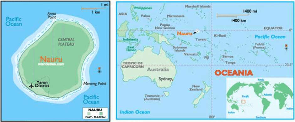
- Location and Geography:
- Nauru is a small island nation in Oceania, situated in the southwestern Pacific Ocean. It is the smallest republic in the world, covering just 8 square miles, with a population of approximately 12,500.
- The island lies 1,300 km northeast of the Solomon Islands, and its closest neighbour is Banaba Island in Kiribati, about 300 km to the east.
- Nauru is a raised coral atoll, primarily composed of fossilised coral and phosphate rock. A central phosphate plateau, surrounded by coral cliffs, dominates the island’s landscape.
- Extensive phosphate mining has severely degraded the interior, rendering about 80% of the land uninhabitable and barren. Despite this, the coastal belt remains habitable, with most of the population residing there.
- Unlike most nations, Nauru has no official capital, though Yaren serves as its de facto capital.
- The country’s official language is Nauruan, but English is widely spoken, particularly in governance and commerce. Nauru follows a Westminster-style parliamentary system, established through its 1968 constitution upon gaining independence.
- Rising Sea level:
- Rising sea levels pose a significant existential threat to Nauru. With an average elevation of just 10 meters above sea level, coastal areas are highly vulnerable to flooding and erosion.
- According to climate studies, sea levels in the Pacific have been rising at a rate of 4-5 mm per year, which is twice the global average. If this trend continues, Nauru’s low-lying settlements could face severe inundation in the coming decades, forcing mass displacement.
- The government is actively seeking solutions, including selling citizenships to fund relocation efforts, as the nation grapples with the pressing reality of climate-induced displacement.
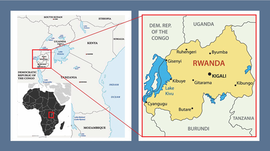
Lake Kivu
Why in news?
- Traffic on Lake Kivu resumes after being suspended on February 7 due to escalating M23 rebel advances in DR Congo, where intensified clashes near the Rwandan border have displaced thousands and heightened instability.
About Lake Kivu:
-
- Location:
- Location:
- Lake Kivu is one of the African Great Lakes, located on the border between Rwanda and the Democratic Republic of the Congo (DRC).
- It lies in the Albertine Rift, a western branch of the East African Rift system. Covering an area of 2,700 square kilometres, the lake sits at an elevation of 1,460 meters above sea level.
- It is surrounded by volcanic mountains, including Mount Nyiragongo and Mount Karisimbi, making it a tectonically active region.
- The lake is deep and stratified, with its maximum depth reaching 485 meters.
- Potential Resources:
- Potential Resources:
- Lake Kivu holds immense resource potential, particularly in its methane gas reserves. The lake contains an estimated 60 billion cubic meters of methane and 300 billion cubic meters of carbon dioxide, trapped in its deep waters.
- If harnessed efficiently, methane extraction could provide a sustainable energy source for Rwanda and the DRC, reducing reliance on fossil fuels and enhancing regional energy security.
- Rwanda has already initiated methane extraction projects for electricity generation, showcasing the lake's economic potential.
- Additionally, fishing remains an important livelihood for local communities, with species like sambaza (small fish) and tilapia being commonly harvested.
- Challenges in the region:
- Challenges in the region:
- The risk of limnic eruptions, where dissolved gases could suddenly escape, poses a potential disaster for millions of people living around the lake. Earthquakes or volcanic activity could trigger gas release, suffocating nearby populations.
- Additionally, pollution, overfishing, and climate change threaten the lake's ecosystem.
- The ongoing conflict in eastern DRC, particularly with M23 rebel activity, disrupts economic activities and endangers local communities.
- Sustainable resource management and regional cooperation are essential to balancing economic development with environmental and human safety.
Palar River
Why in news?
- The Palar River in Tamil Nadu faces severe pollution from tannery waste, leading to contaminated groundwater and environmental degradation.
About Palar River:
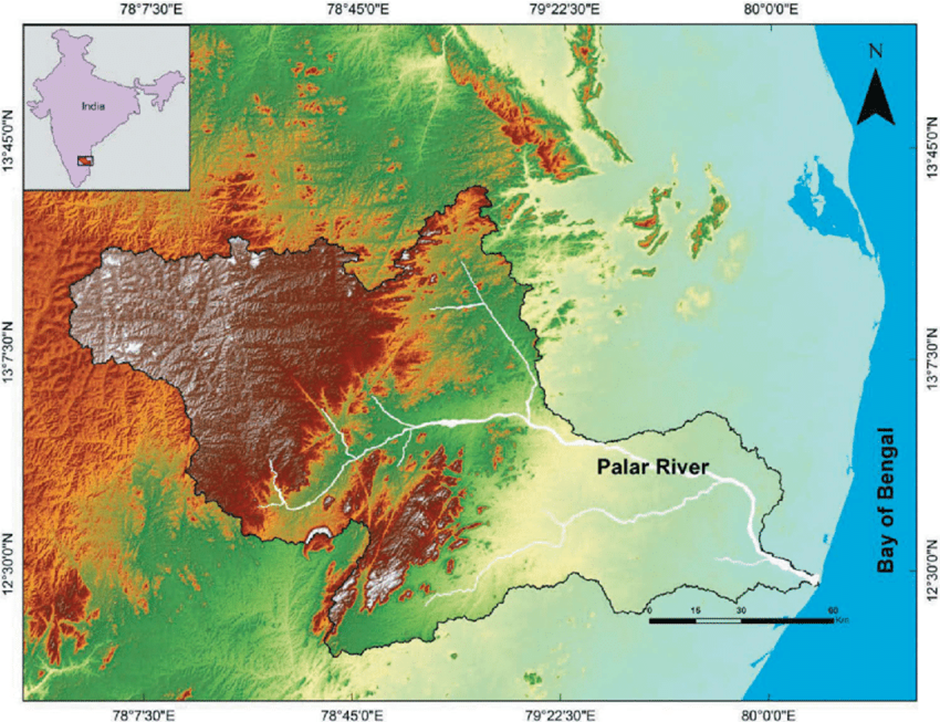
- Origin and Path:
- The Palar River originates in the Nandi Hills of Karnataka, flowing through Andhra Pradesh and Tamil Nadu before emptying into the Bay of Bengal.
- Covering a distance of approximately 348 km, it serves as a crucial water source for irrigation and drinking water in its basin.
- However, seasonal fluctuations and over-extraction have led to a decline in water levels, making it highly dependent on rainfall.
- Tannery Pollution in the Region:
- The river has suffered extensive pollution due to tannery waste, particularly in the Vellore district of Tamil Nadu, a major hub for leather industries.
- Tanneries in this region discharge toxic chemicals such as chromium, sulphides, and acids directly into the river, contaminating the surface and groundwater.
- The lack of effective waste treatment facilities and unchecked industrial expansion have exacerbated the problem.
- Impact of Pollution:
- The impact of tannery pollution on the Palar River is severe. Groundwater contamination has made drinking water unsafe, affecting the health of local communities.
- Agricultural lands irrigated with polluted water have shown declining soil fertility, leading to lower crop yields.
- The high chromium content poses serious health risks, including skin diseases and organ damage. Additionally, the pollution threatens aquatic life, leading to biodiversity loss.
- Urgent measures such as strict environmental regulations, improved waste treatment, and sustainable industrial practices are needed to restore the ecological balance of the Palar River and protect livelihoods.
Pench Tiger Reserve
Why in news?
- A sound-and-light-proof highway near Madhya Pradesh’s Pench Tiger Reserve helps reduce wildlife accidents by minimizing noise and light disturbances, ensuring safer movement for tigers and other animals.
About Pench Tiger Reserve:
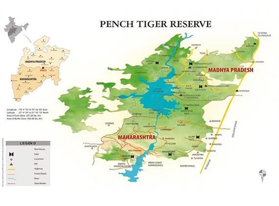
- Location:
- Pench Tiger Reserve is located in Madhya Pradesh and Maharashtra, named after the Pench River, which flows through it.
- Spread over 758 sq km, it is one of India’s most significant tiger habitats and is a part of Project Tiger.
- The Pench River, originating from Madhya Pradesh, is the lifeline of the reserve, providing water to the region's diverse flora and fauna before merging with the Kanhan River.
- Flora and Fauna:
- The flora of Pench Tiger Reserve consists of dry deciduous forests, with dominant tree species such as teak, mahua, tendu, and dhaora.
- The forest is interspersed with grasslands and shrubs, creating an ideal habitat for herbivores and predators.
- The fauna of the reserve is rich and includes around 40 species of mammals, 210 species of birds, 50 species of reptiles, and numerous amphibians and insects.
- It is home to Royal Bengal tigers, Indian leopards, wild dogs (dholes), sloth bears, and striped hyenas.
- Herbivores like spotted deer (chital), sambar deer, and Indian gaur (bison) are commonly found.
- The Pench River and its water bodies support aquatic species, including mugger crocodiles and freshwater turtles.
- Wildlife accidents in protected areas and measures taken:
- Wildlife accidents are a growing concern in protected areas like Pench. The construction of highways, railways, and human encroachments has led to frequent roadkills, endangering species like tigers, leopards, deer, and smaller mammals.
- The NH-44 highway, which passes through the reserve, has been particularly dangerous, causing numerous animal fatalities due to speeding vehicles and light disturbances.
- To address these threats, several measures have been implemented and proposed:
- Sound-and-light-proof highways have been developed to minimise noise and glare, reducing stress and road accidents for wildlife.
- Eco-bridges (wildlife corridors) and underpasses facilitate the safe movement of animals across highways.
- Speed limits and signage are enforced to warn drivers about wildlife crossings.
- Fencing along highways helps prevent animals from straying onto roads.
- Community awareness programs educate local populations and tourists about the importance of wildlife conservation and responsible driving in protected areas.
- While these measures have helped reduce accidents, continued efforts, including better enforcement of wildlife protection laws, habitat conservation, and sustainable development planning, are crucial to ensuring coexistence between humans and wildlife in Pench Tiger Reserve.
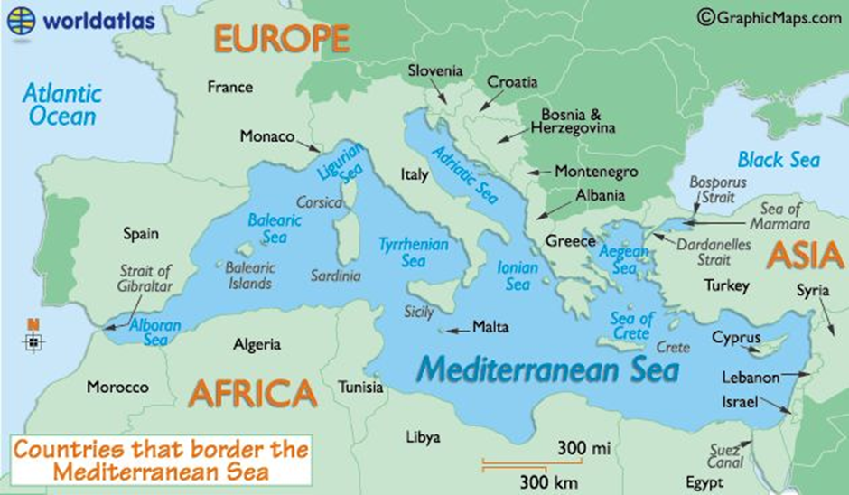
Mediterranean Sea
Why in news?
- Germany is increasing its military and diplomatic presence in the Mediterranean Sea, focusing on maritime security, NATO operations, and migrant crisis management, reflecting its broader European and global strategic commitments.
About Mediterranean Sea:
-
-
- Location and Geography:
- Location and Geography:
-
- The Mediterranean Sea is a semi-enclosed sea connected to the Atlantic Ocean through the Strait of Gibraltar. It is surrounded by Europe to the north, Africa to the south, and Asia to the east, covering approximately 2.5 million square kilometres.
- The sea borders 21 countries, including Spain, France, Italy, Greece, Turkey, Egypt, Libya, Algeria, and Israel.
- It connects to the Black Sea via the Bosporus Strait and to the Red Sea through the Suez Canal, making it a crucial maritime route.
- The geography of the Mediterranean is diverse, with numerous islands, including Sicily, Cyprus, Crete, and Sardinia.
- It features several peninsulas, such as the Iberian, Italian, and Balkan Peninsulas, and has varied coastlines, ranging from sandy beaches to rugged cliffs.
- The Mediterranean Basin is tectonically active, with regions prone to earthquakes and volcanic activity, especially near Italy and Greece.
- The climate of the Mediterranean is classified as Mediterranean climate, characterised by hot, dry summers and mild, wet winters.
- The region experiences seasonal winds, such as the Mistral in France and the Sirocco from North Africa, which influence local weather patterns.
- In recent years, the Mediterranean has witnessed Medicanes (Mediterranean hurricanes)—intense storms with tropical characteristics—posing risks to coastal communities.
- Climate change has exacerbated rising sea levels, extreme heat, and reduced rainfall, impacting agriculture and water resources.
-
- Strategic importance and challenges:
- Strategic importance and challenges:
-
- The sea serves as a vital maritime trade route, connecting Europe, Africa, and Asia. The Suez Canal, a key chokepoint, facilitates global trade by shortening the route between Europe and Asia, making it crucial for energy and goods transportation.
- The region also holds vast energy reserves, with major offshore oil and gas fields in the Eastern Mediterranean near Cyprus, Israel, and Egypt, fuelling geopolitical tensions.
- The Mediterranean is also central to global security and military operations. NATO maintains a strong presence, conducting naval patrols and counterterrorism operations.
- The region has seen ongoing migrant crises, with thousands crossing from North Africa to Europe, prompting EU nations to enhance border security and humanitarian efforts.
- Additionally, territorial disputes, such as those between Turkey, Greece, and Cyprus over maritime boundaries, contribute to regional instability.
- As global dynamics shift, the Mediterranean remains a key geopolitical hotspot, requiring cooperation between nations for security, economic growth, and environmental sustainability.
|
UPSC CSE PYQs
Q1. Mediterranean Sea is a border of which of the following countries? (2017)
Select the correct answer using the code given below:
Answer: Option C
|
|
Also Read |
|
Democracy Demands Clarity: Onus on the Election Commission
Operation Sindhu: India Begins Evacuation from Conflict-Hit Iran

Revising GDP Base Year
Karol Bagh Metro Pillar No. 112, Above Domino's, 22B, First Floor, New Delhi - 110060
Very Important Instruction For Any Issue, Student Must Produce His/Her Fee Receipt. Without Fee Receipt, It Will Not Be Possible To Track Your Details. If You Have Been Given Any Special Consideration, You Must Keep That In Writing And Produce In Case Of Conflict.
Copyright © 2024-2026 ENSURE IAS. All rights reserved.