- Courses
- GS Full Course 1 Year
- GS Full Course 2 Year
- GS Full Course 3 Year
- GS Full Course Till Selection
- Answer Alpha: Mains 2025 Mentorship
- MEP (Mains Enrichment Programme) Data, Facts
- Essay Target – 150+ Marks
- Online Program
- GS Recorded Course
- Polity
- Geography
- Economy
- Ancient, Medieval and Art & Culture AMAC
- Modern India, Post Independence & World History
- Environment
- Governance
- Science & Technology
- International Relations and Internal Security
- Disaster Management
- Ethics
- NCERT Current Affairs
- Indian Society and Social Issue
- NCERT- Science and Technology
- NCERT - Geography
- NCERT - Ancient History
- NCERT- World History
- NCERT Modern History
- CSAT
- 5 LAYERED ARJUNA Mentorship
- Public Administration Optional
- ABOUT US
- OUR TOPPERS
- TEST SERIES
- FREE STUDY MATERIAL
- VIDEOS
- CONTACT US
PLACES IN NEWS 02 DECEMBER 2024
PLACES IN NEWS 02 DECEMBER 2024
Vadhavan Port
Why in news?
The Vadhavan greenfield port near Dahanu, Maharashtra, set for completion by 2034, is projected to double India’s container trade and rank among the world's top 10 ports.
About Vadhavan Port:
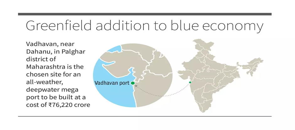
- Vadhavan Port is a proposed deep-sea port located in Vadhavan, Palghar district, Maharashtra, along the Arabian Sea coast.
- It will be India’s first offshore port, constructed on an artificial island, and the second Mother Port after Vizhinjam International Seaport in Thiruvananthapuram.
- The port's construction cost is estimated at ₹76,220 crore (US$9.1 billion).
- The project will be implemented by Vadhavan Port Project Limited, a special purpose vehicle with 74% stake by Jawaharlal Nehru Port Authority (JNPA) and 26% by Maharashtra Maritime Board under a public-private partnership model.
- The port will feature an artificial harbour, with berths and an inner navigable channel surrounded by breakwaters, while the outer navigable channel will remain open to the sea.
- It will include container berths, liquid berths, ro-ro berths, and multipurpose cargo berths, catering to diverse cargo types.
- The location, 10 km from Vadhaban Point, has a natural depth of 20 metres (66 ft), enabling it to handle large vessels.
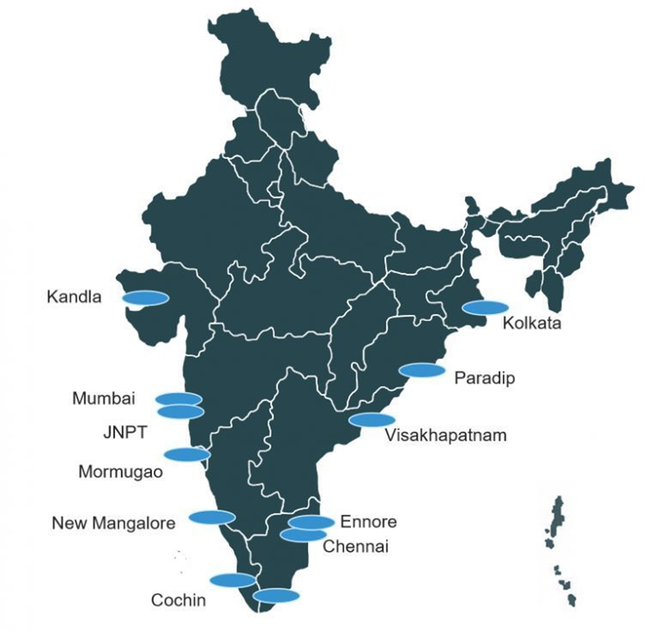
major ports in India:
|
Port |
Location |
Key features |
|
Kolkata (Syama Prasad Mookerjee) |
West Bengal |
|
|
Paradip |
Odisha |
|
|
Visakhapatnam |
Andhra Pradesh |
|
|
Chennai |
Tamil Nadu |
|
|
Tuticorin (V.O. Chidambaranar) |
Tamil Nadu |
|
|
Cochin |
Kerala |
|
|
Marmagao |
Goa |
|
|
Mumbai |
Maharashtra |
|
|
Jawaharlal Nehru (Nhava Sheva) |
Maharashtra |
|
|
Kandla (Deendayal) |
Gujarat |
|
|
Ennore (Kamarajar) |
Tamil Nadu |
|
|
Mangalore |
Karnataka |
|
Taiwan
Why in news?
- Taiwanese President Lai Ching-te, during a U.S. stopover on his Pacific tour, emphasized the need to "fight together to prevent war," highlighting Taiwan's reliance on U.S. support amid China's military threats.
- Lai's trip includes visits to Taiwan’s Pacific allies and U.S. territories, aiming to deepen democratic and economic ties.
- China's Foreign Ministry condemned Lai’s U.S. stopover, vowing to defend its sovereignty, while its military reiterated opposition to Taiwan’s independence.
- The tour coincides with U.S. arms sales to Taiwan and President-elect Trump’s forthcoming term.
About Taiwan:
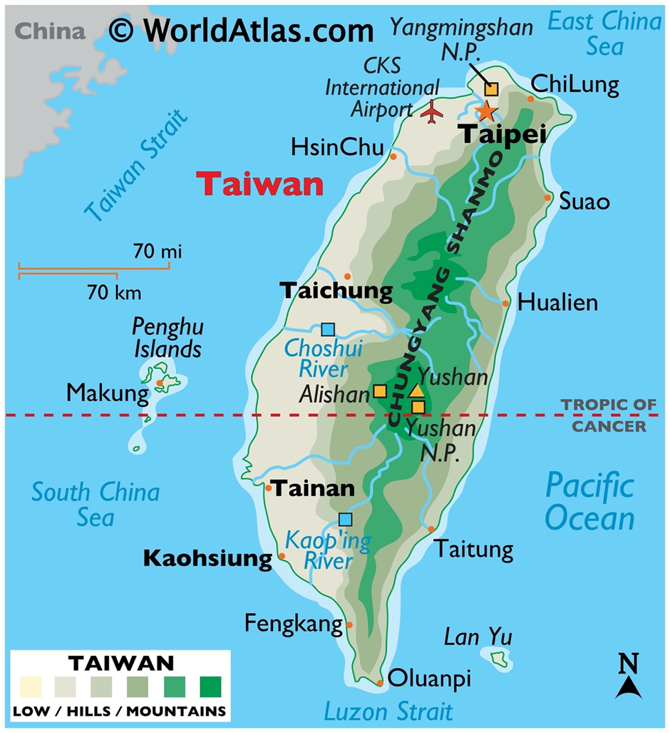
Geographical location:
- The Taiwan (or Republic of China) controls 168 islands spanning 36,193 sq km (13,974 sq mi), with the main island, Formosa, comprising 99% of the area.
- The main island, 35,808 sq km (13,826 sq mi), lies 180 km (112 mi) from mainland China across the Taiwan Strait.
- It is bordered by the East China Sea (north), Philippine Sea (east), Luzon Strait (south), and South China Sea (southwest).
- Smaller islands include Penghu, Kinmen, Matsu, Wuqiu, and some in the South China Sea.
- The main island is a tilted fault block with rugged eastern mountains and western plains, home to most of the population.
- Taiwan is tectonically active, with frequent earthquakes and submarine volcanoes.
- Four ecoregions span forests and rainforests, with intensive land use in the west.
International status:
- The political and legal status of Taiwan is highly debated. The People’s Republic of China (or China) claims Taiwan as part of its territory and views itself as the successor to the Republic of China (ROC) since 1949.
- Taiwan operates independently with its own currency, passport, postage stamps, military, constitution, and an elected president.
- After 1928, the Kuomintang (KMT) unified China under the ROC, gaining diplomatic recognition. Following the Kuomintang’s retreat to Taiwan, many countries initially recognized the ROC but shifted to the PRC in the 1970s.
- United Nations Resolution 2758 in 1971 recognized the PRC as the sole representative of China in the United Nations. The ROC lost its UN membership and now has formal relations with only 11 countries.
- The PRC opposes any nation having formal ties with Taiwan. The ROC maintains unofficial relations through entities like Taipei Economic and Cultural Representative Offices, which handle diplomatic and consular functions.
- From 1954 to 1979, Taiwan and the United States were partners in a defence treaty. The United States still supports Taiwan through the Taiwan Relations Act, selling arms and providing military training while discouraging PRC aggression.
- Taiwan has pursued closer economic ties with South and Southeast Asian countries through its New Southbound Policy, although some issues of exploitation of workers and students have created challenges.
- The PRC promotes its One China principle, claiming both Taiwan and mainland China as part of one country under its governance. Taiwan opposes this and rejects the "one country, two systems" model used in Hong Kong.
- Cross-strait relations are managed by the Mainland Affairs Council (Taiwan) and the Taiwan Affairs Office (China), with private organizations facilitating exchanges. The 1992 Consensus suggested one China but with differing interpretations by both sides.
- Taiwan, originally a founding member of the United Nations, was expelled in 1971. It participates in international organizations like the World Health Organization and the World Trade Organization under the name "Chinese Taipei".
- Taiwan has been part of the Unrepresented Nations and Peoples Organization since 1991, representing itself as Taiwan and working to preserve its identity on the global stage despite limited recognition.
Senegal
Why in news?
- On December 1st, 2024, Senegal commemorated the 80th anniversary of the Thiaroye massacre, where French troops killed African soldiers demanding fair treatment after World War II.
- French President Emmanuel Macron acknowledged the killings as a "massacre" in a letter to Faye, marking a step toward honouring victims.
- The ceremony included a visit to the Thiaroye military cemetery to honour the victims.
About Senegal:
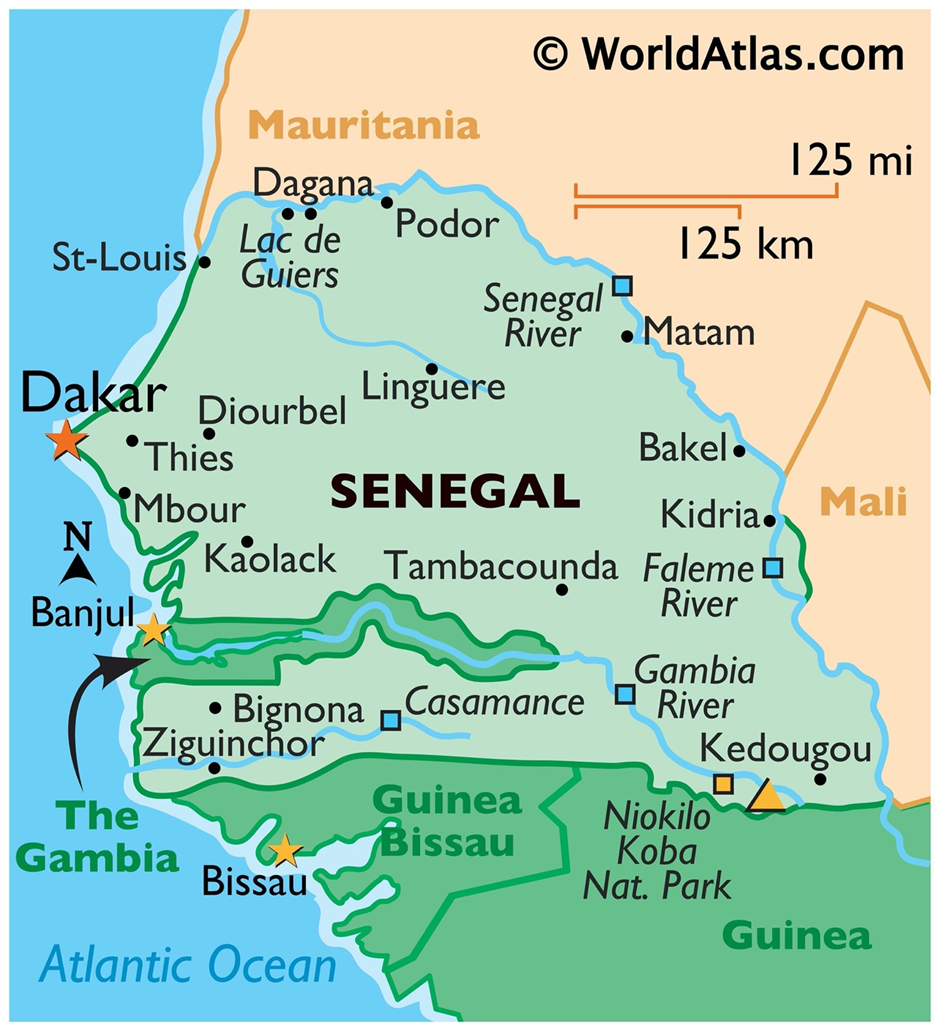
Geography:
- Senegal is located in West Africa, bordered by the Atlantic Ocean to the west, with a coastline of about 530 kilometres.
- It shares borders with Mauritania to the north and east, Mali to the east, and Guinea and Guinea-Bissau to the south.
- The country has a mostly flat landscape, with savannas and forests in the south and semi-desert regions in the north.
- The Senegal River forms the northern border, while the Gambia River runs through the country, dividing it into two parts.
- The climate is tropical, with a rainy season from May to October and a dry season from November to April.
- The country is home to diverse ecosystems, including coastal wetlands, mangrove swamps, and savanna grasslands, supporting a variety of wildlife.
- Senegal has several national parks and reserves, such as Niokolo-Koba National Park, a UNESCO World Heritage Site.
Colonial history and independence:
- In the mid-15th century, Portuguese traders landed on Senegal's coast, followed by the French, British, and Dutch.
- In 1677, France gained control of Gorée Island, a key point in the Atlantic slave trade.
- The French expanded onto the mainland in the 1850s, abolishing slavery and annexing local kingdoms, except for the Serer Kingdoms of Sine and Saloum.
- Senegalese resistance was led by figures like Lat-Dior and the King of Sine, leading to battles such as the Battle of Logandème.
- In 1915, over 300 Senegalese fought under Australian command in the Middle East.
- In 1944, the Thiaroye massacre occurred when Senegalese soldiers, who had fought for France during World War II, demanded compensation upon returning home. The French military responded by surrounding and gunning them down, killing dozens, with some estimates suggesting hundreds of deaths.
- Senegal became an autonomous republic in 1958 and, in 1959, merged with French Sudan to form the Mali Federation, which dissolved in 1960.
- Senegal gained independence on 20 June 1960, with Léopold Sédar Senghor as the first president.
- Senghor’s government allowed limited opposition and oversaw a peaceful transition to a multi-party system in 1975.
Jim Corbett National Park
Why in news?
- Camera traps, initially intended for wildlife monitoring, have been used to secretly observe women in villages near Jim Corbett National Park.
- These women previously found solace in the forest, a man-free space where they could gather, talk, and sing. However, with the introduction of surveillance, this space has become unsafe, as the women are now aware of being watched by men.
- This surveillance has made them vulnerable to both human and animal predators, with tragic results. The situation highlights the deeper issue of gender inequality in India, where women's safety, freedom, and privacy are compromised.
About Jim Corbett National Park:
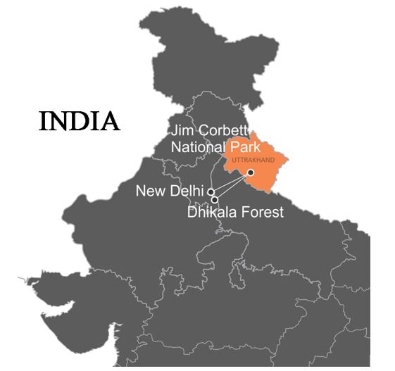
- Jim Corbett National Park, located in Nainital district, Uttarakhand, is India's first national park, established in 1936 and initially called Hailey National Park.
- It was renamed Corbett National Park in 1956 after Jim Corbett, a famous hunter and naturalist who helped establish the park.
- The park spans an area of 520.8 km², with an elevation range from 1,300 ft to 4,000 ft and diverse geographical features like hills, riverine belts, marshy depressions, and grasslands.
- It is a sub-Himalayan region with dense moist deciduous forests, including trees like sal, haldu, peepal, and mango. About 73% of the park is forested, and 10% consists of grasslands.
- The park is home to 50 species of mammals, including the Bengal tiger, Indian elephant, and Indian leopard. Over 580 bird species and 25 reptile species are also found here.
- The park is a part of the Project Tiger initiative, launched in 1974 to conserve tiger populations, and it forms part of the Terai Arc Landscape program aimed at linking protected areas for wildlife migration.
- The Ramganga River flows through the park, with several other smaller streams and ravines contributing to its water resources.
- The park's climate is temperate with temperatures ranging from 5°C to 30°C in winter, and summer temperatures reaching up to 40°C. It experiences heavy rainfall during the monsoon season (July to September).
- Flora includes 617 species of plants, with significant trees like Sal, jamun, and mallotus. Fauna includes species like barking deer, sambar deer, chital, and sloth bears.
- Ecotourism has become a significant part of the park's economy, but it also presents challenges for maintaining the ecological balance.

Must Check: Best IAS Coaching In Delhi
UPSC Prelims Result 2024 Out: Expected Cut Off & Other Details, UPSC Prelims 2024 Answer with Explanation, Daily Prelims Quiz, Daily Current Affairs, MONTHLY CURRENT AFFAIRS TOTAL (CAT) MAGAZINE, Best IAS Coaching Institute in Karol Bagh, Best IAS Coaching Institute in Delhi, Daily Mains Question Answer Practice, ENSURE IAS UPSC Toppers, UPSC Toppers Marksheet, Previous Year Interview Questions, UPSC Syllabus
ECI to Verify Voter List in Bihar
India Opens Doors to Foreign Universities

Coordination Between Fiscal and Monetary Policy
Karol Bagh Metro Pillar No. 112, Above Domino's, 22B, First Floor, New Delhi - 110060
Very Important Instruction For Any Issue, Student Must Produce His/Her Fee Receipt. Without Fee Receipt, It Will Not Be Possible To Track Your Details. If You Have Been Given Any Special Consideration, You Must Keep That In Writing And Produce In Case Of Conflict.
Copyright © 2024-2026 ENSURE IAS. All rights reserved.