- Courses
- GS Full Course 1 Year
- GS Full Course 2 Year
- GS Full Course 3 Year
- GS Full Course Till Selection
- Answer Alpha: Mains 2025 Mentorship
- MEP (Mains Enrichment Programme) Data, Facts
- Essay Target – 150+ Marks
- Online Program
- GS Recorded Course
- Polity
- Geography
- Economy
- Ancient, Medieval and Art & Culture AMAC
- Modern India, Post Independence & World History
- Environment
- Governance
- Science & Technology
- International Relations and Internal Security
- Disaster Management
- Ethics
- NCERT Current Affairs
- Indian Society and Social Issue
- NCERT- Science and Technology
- NCERT - Geography
- NCERT - Ancient History
- NCERT- World History
- NCERT Modern History
- CSAT
- 5 LAYERED ARJUNA Mentorship
- Public Administration Optional
- ABOUT US
- OUR TOPPERS
- TEST SERIES
- FREE STUDY MATERIAL
- VIDEOS
- CONTACT US
Mullaperiyar dam case: T.N. rejects Survey of India report
Mullaperiyar dam case: T.N. rejects Survey of India report
On Monday, the Supreme Court fixed July 10 to hear and finalize the legal issues in the original suit filed by Tamil Nadu against neighboring state Kerala over the construction of a mega parking project near Mullaperiyar Dam.
- A Bench recorded Tamil Nadu’s objection to the findings of the Survey of India report on the parking project.
- The case concerns the construction of a mega parking project near the Mullaperiyar dam.
- Tamil Nadu objects to the Survey of India report, claiming it incorrectly states the project is outside the leased area.
- The court directed the Survey of India to demarcate the leased area and ascertain if the project encroaches on it.
- Tamil Nadu argues the would environmentally affect the catchment area, the water spread area of the dam and consequently the waters of the reservoir, used for drinking and irrigation purposes by the people of five districts of Tamil Nadu.
- Kerala denies the allegations and claims that the 1886 lease agreement does not grant exclusive property rights to Tamil Nadu.
What is the Mullaperiyar Dam issue?
- Mullaperiyar Dam is a source of dispute between the states of Tamil Nadu and Kerala.
- The dam is located in Kerala on the upper reaches of the Periyar River, which originates in Tamil Nadu.
- Tamil Nadu owns, operates and maintains this dam, which was built between 1887 and 1895.
- The controversy centers on the structural stability of the dam and the threat it poses to the safety of the people of Kerala in the event of a dam breach.
- A UN report said the dam has major structural flaws and if the dam collapses, 5 million people will be at risk.
- Kerala has also challenged the validity of the 1886 lease agreement.
- This controversy has arisen again after the recent rains.
- The Supreme Court has ordered both the states to follow the recommendation of the court-appointed supervisory committee, which had suggested a permissible level of 139.50 feet.
- Tamil Nadu wanted the level set by the Supreme Court in 2014 to be raised to 142 feet, while Kerala wanted it within 139 feet.
What is Mullaperiyar 886 lease agreement?
Although the dam is located in Kerala, it is operated by Tamil Nadu following an 1886 lease indenture for 999 years that was signed between the Maharaja of Travancore and the Secretary of State for India for the Periyar Irrigation works.
About Survey of India:
The Survey of India (SOI) is the national survey and mapping organization of India, operating under the Department of Science and Technology.
- Established in 1767, it is the oldest scientific department of the Government of India and has a rich history of providing accurate mapping data for various purposes.
Key Responsibilities and Duties of the SoI:
- Geodetic Control and Surveys: Conducting geodetic surveys, geodetic control, and geophysical surveys.
- Topographical Control, Surveys, and Mapping: Performing topographical control, surveys, and mapping within India.
- Map Production: Creating and publishing geographical maps and aeronautical charts.
- Surveys for Development Projects: Conducting surveys for developmental projects.
- Specialized Surveys: Surveying forests, cantonments, cities, cadastral areas, and other specific areas.
- Special Map Surveys: Creating and publishing special maps.
- Geographical Name Spellings: Ensuring the correct spelling of geographical names.
- Boundary Demarcation: Demarcating India's external boundaries, depicting them on maps, and advising on interstate boundary demarcation.
- Research and Development: Conducting research and development in cartography, printing, geodesy, photogrammetry, topographical surveys, and indigenization.
- Tide Prediction and Publication: Predicting tides at various ports, including foreign ports, and publishing tide tables one year in advance to aid navigational activities.
- External Boundary Scrutiny and Certification: Scrutinizing and certifying the external boundaries of India and the coastline on maps published by other agencies, including private publishers.
Significance of the SoI:
- National Mapping Agency: The SoI serves as the principal mapping agency of India, ensuring that the country's domain is explored and mapped accurately to provide base maps for integrated development.
- Technology and Expertise: The SoI utilizes advanced technology to meet the needs of defense forces, planners, and scientists in various fields.
- Expert Advice: The SoI provides expert advice to various ministries and undertakings of the Indian government on survey matters, including international borders, state boundaries, and planned development of underdeveloped areas.
- Scientific Collaboration: The SoI assists in scientific programs related to geo-physics, remote sensing, and digital data transfers.
- Advisory Role: The SoI acts as an advisor to the Government of India on all survey matters, including geodesy, photogrammetry, mapping, and map reproduction.
FAQs:
Q: What is Cartography?

Cartography is the study and practice of making and using maps. Combining science, aesthetics and technique, cartography builds on the premise that reality can be modeled in ways that communicate spatial information effectively.
Q: What is geodetic survey
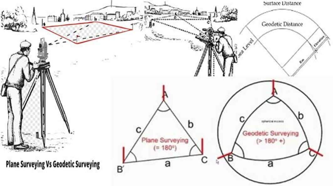
A geodetic survey is a survey of a large land area that takes into account the curvature of the Earth's surface. It uses a reference system, such as the World Geodetic System 1984 (WGS84), to define the coordinates and elevations of points on the Earth.
Geodetic surveys are used in civil construction and structural monitoring to:
- Determine the precise position of distant points on the Earth's surface
- Get reconnaissance information and preliminary data required by engineers for selecting suitable routes and sites
- Prepare efficient structural designs
Must Check: Best IAS Coaching In Delhi
HAL-ISRO Deal on SSLVs

India’s EV Surge: Manufacturing for the Future

PLACES IN NEWS 21st June 2025
Karol Bagh Metro Pillar No. 112, Above Domino's, 22B, First Floor, New Delhi - 110060
Very Important Instruction For Any Issue, Student Must Produce His/Her Fee Receipt. Without Fee Receipt, It Will Not Be Possible To Track Your Details. If You Have Been Given Any Special Consideration, You Must Keep That In Writing And Produce In Case Of Conflict.
Copyright © 2024-2026 ENSURE IAS. All rights reserved.