- Courses
- GS Full Course 1 Year
- GS Full Course 2 Year
- GS Full Course 3 Year
- GS Full Course Till Selection
- Answer Alpha: Mains 2025 Mentorship
- MEP (Mains Enrichment Programme) Data, Facts
- Essay Target – 150+ Marks
- Online Program
- GS Recorded Course
- Polity
- Geography
- Economy
- Ancient, Medieval and Art & Culture AMAC
- Modern India, Post Independence & World History
- Environment
- Governance
- Science & Technology
- International Relations and Internal Security
- Disaster Management
- Ethics
- NCERT Current Affairs
- Indian Society and Social Issue
- NCERT- Science and Technology
- NCERT - Geography
- NCERT - Ancient History
- NCERT- World History
- NCERT Modern History
- CSAT
- 5 LAYERED ARJUNA Mentorship
- Public Administration Optional
- ABOUT US
- OUR TOPPERS
- TEST SERIES
- FREE STUDY MATERIAL
- VIDEOS
- CONTACT US
Magellan Mission
Magellan Mission
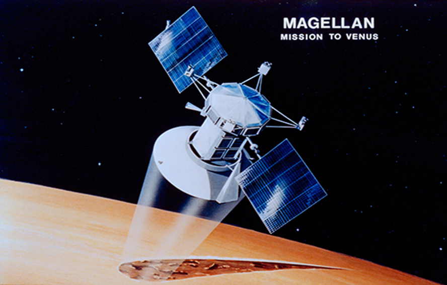
Scientists analysed archived data from NASA's Magellan mission and observed new lava flows on Venus, indicating volcanic activity between 1990 and 1992.
About Magellan Mission:
- Mission Launch: Magellan was a NASA deep space mission launched on May 4, 1989, to explore Venus.
- Launch Details: It was launched from Cape Canaveral aboard the space shuttle Atlantis, marking the first interplanetary mission launched from the Space Shuttle and the first spacecraft to use the Inertial Upper Stage booster.
- Mission Name: The mission was named after Ferdinand Magellan, the Portuguese explorer who was the first to circumnavigate the Earth.
- Mission Goal: The primary goal of the Magellan mission was to map the surface of Venus using radar imaging due to the planet's thick atmosphere, which obstructed visual observation.
- Major Achievements: The Magellan spacecraft arrived at Venus in 1990 and achieved several significant accomplishments:
a. It created the first global map of the surface of Venus using radar imaging.
b. It produced global maps of the planet's gravity field. - Surprising Findings: Magellan's mission revealed surprising discoveries about Venus, including a relatively young planetary surface possibly formed by volcanic eruptions.
- Mission Conclusion: In October 1994, the Magellan spacecraft intentionally crashed into Venus's surface to gather atmospheric data before ceasing operations.
- This marked the first time an operating planetary spacecraft had been intentionally crashed.
What is Radar Imaging?
Radar imaging is a technology that uses radar systems to create detailed images of objects or landscapes. It works by transmitting radio waves and analysing the echoes that bounce back from the target. These echoes contain information about the distance, shape, and other characteristics of the object being observed.
How Radar Imaging Works
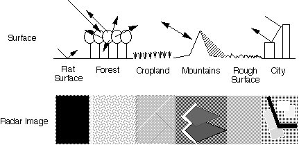
- Transmission: A radar system emits radio waves in pulses or continuous waves. These waves travel through the air at the speed of light.
- Reflection: When the radio waves encounter an object, they are scattered in various directions. Some of the waves are reflected back towards the radar system.
- Reception: The radar system's antenna receives the reflected waves, which are then amplified and processed.
- Signal Processing: The received signals are analysed to extract information about the target's distance, angle, and other characteristics. This information is used to create a radar image.
Types of Radar Imaging
- Real Aperture Radar (RAR): This is the most basic type of radar imaging, where the resolution of the image depends on the size of the antenna. Larger antennas produce higher resolution images.
- Synthetic Aperture Radar (SAR): This advanced technique uses the motion of the radar system to synthesise a larger antenna aperture, resulting in much higher resolution images than RAR.
- Inverse Synthetic Aperture Radar (ISAR): This technique is used to image moving targets. It exploits the target's motion to create a synthetic aperture and generate a high-resolution image.
Applications of Radar Imaging
Radar imaging has a wide range of applications in various fields:
- Remote Sensing: Radar imaging is used to map the Earth's surface, monitor environmental changes, and track weather patterns.
- Military: Radar imaging is used for surveillance, target tracking, and missile guidance.
- Aviation: Radar imaging is used for air traffic control, navigation, and terrain avoidance.
- Space Exploration: Radar imaging is used to map the surfaces of planets, moons, and asteroids.
- Autonomous Vehicles: Radar imaging is used for object detection and obstacle avoidance in self-driving cars.
Advantages of Radar Imaging
Radar imaging offers several advantages over other imaging technologies:
- All-Weather Capability: Radar imaging can penetrate clouds, fog, and smoke, making it suitable for all-weather conditions.
- Day/Night Operation: Radar imaging does not rely on sunlight, allowing it to operate day and night.
- Long Range: Radar imaging can be used to image objects at long distances.
- Penetration: Radar imaging can penetrate some materials, such as soil and vegetation, revealing hidden objects.
Limitations of Radar Imaging
Radar imaging also has some limitations:
- Lower Resolution: Compared to optical imaging, radar imaging generally has lower resolution.
- Speckle: Radar images often suffer from speckle, a granular noise pattern that can degrade image quality.
- Complex Processing: Radar image processing can be complex and computationally intensive.
Future of Radar Imaging
Radar imaging technology is continuously evolving, with ongoing research and development in areas such as:
- Higher Resolution: Scientists are developing new techniques to achieve higher resolution radar images.
- 3D Imaging: Radar imaging is being extended to create three-dimensional images of objects and landscapes.
- Polarimetric Imaging: This technique measures the polarization of the reflected waves, providing additional information about the target's properties.
Radar imaging is a powerful tool with diverse applications. Its unique capabilities make it invaluable for remote sensing, military, aviation, space exploration, and autonomous vehicles. With continued advancements, radar imaging is expected to play an even more significant role in the future.
Must Check: UPSC Coaching Institute In Delhi

ECI to Verify Voter List in Bihar

India Opens Doors to Foreign Universities

Coordination Between Fiscal and Monetary Policy
Karol Bagh Metro Pillar No. 112, Above Domino's, 22B, First Floor, New Delhi - 110060
Very Important Instruction For Any Issue, Student Must Produce His/Her Fee Receipt. Without Fee Receipt, It Will Not Be Possible To Track Your Details. If You Have Been Given Any Special Consideration, You Must Keep That In Writing And Produce In Case Of Conflict.
Copyright © 2024-2026 ENSURE IAS. All rights reserved.