- Courses
- GS Full Course 1 Year
- GS Full Course 2 Year
- GS Full Course 3 Year
- GS Full Course Till Selection
- Answer Alpha: Mains 2025 Mentorship
- MEP (Mains Enrichment Programme) Data, Facts
- Essay Target – 150+ Marks
- Online Program
- GS Recorded Course
- Polity
- Geography
- Economy
- Ancient, Medieval and Art & Culture AMAC
- Modern India, Post Independence & World History
- Environment
- Governance
- Science & Technology
- International Relations and Internal Security
- Disaster Management
- Ethics
- NCERT Current Affairs
- Indian Society and Social Issue
- NCERT- Science and Technology
- NCERT - Geography
- NCERT - Ancient History
- NCERT- World History
- NCERT Modern History
- CSAT
- 5 LAYERED ARJUNA Mentorship
- Public Administration Optional
- ABOUT US
- OUR TOPPERS
- TEST SERIES
- FREE STUDY MATERIAL
- VIDEOS
- CONTACT US
ISRO Scientists Create First Undersea Mapping of Ram Setu
ISRO Scientists Create First Undersea Mapping of Ram Setu
Recently, scientists from the Indian Space Research Organisation (ISRO) have successfully mapped the submerged structure of Adam's Bridge, also known as Ram Setu, between India and Sri Lanka.
NASA's ICESat-2 satellite.
- This achievement is significant as it provides new insights into the region's history and the formation of this ancient structure.
- The study's findings have sparked interest among historians, archaeologists, and scientists, as they shed light on the origins of the bridge and its connection to the Indian subcontinent.
Background
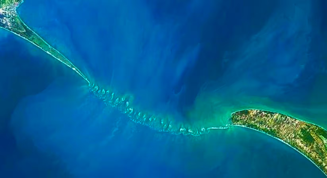
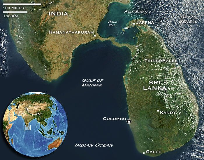
- Adam's Bridge, also known as Ram Setu, is an ancient bridge mentioned in Indian religious texts that connects Rameswaram Island, off the southeast coast of India, to Mannar Island, off the northwest coast of Sri Lanka.
- The bridge is a 48 km long chain of natural limestone shoals that separates the Gulf of Mannar from the Palk Strait.
What is a Strait?
- A strait is a narrow waterway that connects two larger bodies of water.
- Straits are often formed by the erosion of land by water and can be found at the mouth of rivers, between islands, or between continents.
- Examples of straits include the Bosphorus, which connects the Black Sea to the Mediterranean Sea, and the Strait of Malacca, which connects the Indian Ocean to the South China Sea.
About Adam's Bridge
- Adam's Bridge is a submerged ridge that connects India and Sri Lanka.
- It is believed to be a natural formation, created by the accumulation of coral reefs and sandbanks over thousands of years.
- The bridge has been mentioned in Indian religious texts, including the Ramayana, and is considered a sacred site by many Hindus.
Key Points
- ISRO scientists used NASA's ICESat-2 satellite to map the submerged structure of Adam's Bridge.
- The study reveals the bridge's continuity from Dhanushkodi to Talaimannar, with 99.98 per cent of it submerged in shallow waters.
- The research team discovered 11 narrow channels that allowed water to flow between the Gulf of Mannar and Palk Strait.
- The study confirms the origins of Adam's Bridge or Ram Setu, which was once a land connection between India and Sri Lanka.
Methodology
- ISRO scientists used advanced laser technology from NASA's ICESat-2 satellite to create a high-resolution map of the entire length of the submerged ridge.
- The green laser of the NASA satellite helped researchers to go as much as 40 meters deep.
- The researchers used NASA's ICESat-2 data from October 2018 to October 2023 to generate a 10-meter resolution map of the full length of the submerged ridge.
Findings
- The detailed underwater map reveals the bridge's continuity from Dhanushkodi to Talaimannar, with a staggering 99.98 percent of it submerged in shallow waters.
- The research team, led by Giribabu Dandabathula, discovered 11 narrow channels that allowed water to flow between the Gulf of Mannar and Palk Strait, playing a crucial role in preserving the structure from sea waves.
Implications
- The study confirms the origins of Adam's Bridge or Ram Setu, which was once a land connection between India and Sri Lanka.
- The findings provide new insights into the region's history and the formation of this ancient structure.
History of Adam's Bridge
- The submerged structure was named Adam's Bridge by an East India Company mapper.
- The structure described by Indians as Ram Setu is mentioned in the Ramayana as a bridge constructed by Ram's army to help him reach Sri Lanka, Ravana's kingdom, to rescue his wife Sita.
- Persian navigators in the ninth century AD referred to the bridge as Sethu Bandhai or a bridge over the sea.
- Temple records from Rameswaram indicate that the bridge was above sea level until 1480 when it was demolished by a powerful storm.
Must Check: Best IAS Coaching In Delhi
UPSC Prelims Result 2024 Out: Expected Cut Off & Other Details, UPSC Prelims 2024 Answer with Explanation, Daily Prelims Quiz, Daily Current Affairs, MONTHLY CURRENT AFFAIRS TOTAL (CAT) MAGAZINE, Best IAS Coaching Institute in Karol Bagh, Best IAS Coaching Institute in Delhi, Daily Mains Question Answer Practice, ENSURE IAS UPSC Toppers, UPSC Toppers Marksheet, Previous Year Interview Questions, UPSC Syllabus

Sailing into Self-Reliance: The Legacy of INS Tamal

Socialism and Secularism: Foundational Pillars of the Indian Constitution

Forest Clearance for Puri Airport Deferred Over Wildlife Concerns
Karol Bagh Metro Pillar No. 112, Above Domino's, 22B, First Floor, New Delhi - 110060
Very Important Instruction For Any Issue, Student Must Produce His/Her Fee Receipt. Without Fee Receipt, It Will Not Be Possible To Track Your Details. If You Have Been Given Any Special Consideration, You Must Keep That In Writing And Produce In Case Of Conflict.
Copyright © 2024-2026 ENSURE IAS. All rights reserved.