- Courses
- GS Full Course 1 Year
- GS Full Course 2 Year
- GS Full Course 3 Year
- GS Full Course Till Selection
- Answer Alpha: Mains 2025 Mentorship
- MEP (Mains Enrichment Programme) Data, Facts
- Essay Target – 150+ Marks
- Online Program
- GS Recorded Course
- Polity
- Geography
- Economy
- Ancient, Medieval and Art & Culture AMAC
- Modern India, Post Independence & World History
- Environment
- Governance
- Science & Technology
- International Relations and Internal Security
- Disaster Management
- Ethics
- NCERT Current Affairs
- Indian Society and Social Issue
- NCERT- Science and Technology
- NCERT - Geography
- NCERT - Ancient History
- NCERT- World History
- NCERT Modern History
- CSAT
- 5 LAYERED ARJUNA Mentorship
- Public Administration Optional
- ABOUT US
- OUR TOPPERS
- TEST SERIES
- FREE STUDY MATERIAL
- VIDEOS
- CONTACT US
ESA’s Biomass Mission: Monitoring Forests from Space
ESA’s Biomass Mission: Monitoring Forests from Space
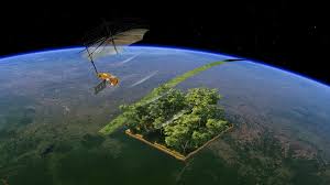
- The European Space Agency (ESA) is launching a ground-breaking Earth Observation mission called “Biomass” on 29 April 2025.
- This mission is crucial in the fight against climate change, monitoring carbon stocks, and understanding the Earth’s carbon cycle
What is the Biomass Mission?
- The Biomass mission is one of ESA’s Earth Explorer Missions, developed under its Living Planet Program.
- Its primary goal is to monitor forest biomass (forest biomass refers to the total mass of living trees and vegetation in a given area.)
- This is the first satellite mission that will use P-band synthetic aperture radar (SAR) to penetrate forest canopies and measure the amount of biomass accurately.
- Mission duration: 5 years, covering all forested regions globally.
- Key Features
|
Feature |
Details |
|
Launched |
April 2025 |
|
Launch Site |
Guiana Space Centre, French Guiana with rocket named Vega-C |
|
Orbit |
Sun-synchronous, ~666 km altitude |
|
Satellite Mass |
~1,260 kg |
|
Instrument |
P-band SAR, using radar waves ~70 cm in wavelength |
|
Revisit Time |
Every 6 months |
|
Coverage |
All forested regions of Earth |
Forest biomass- refers to the total mass of living organic matter in trees and vegetation in a forest ecosystem. It includes- Above-ground biomass: Trunks, branches, leaves, etc., Below-ground biomass: Roots, Deadwood and litter.
Paris Agreement and NDCs-
The Paris Agreement is a legally binding international treaty on climate change adopted in 2015 at the COP21 in Paris.
Its key goals-
- Limit global warming to well below 2°C, aiming for 1.5°C
- Achieve net-zero emissions by the second half of the century
- Enhance climate resilience and low-carbon development
Countries commit to:
- Submit and update their NDCs
- Track progress through transparency mechanisms
- Support developing nations with finance and technology
NDCs (Nationally Determined Contributions)
NDCs are climate action plans submitted by each country under the Paris Agreement.
They outline how a country plans to, Reduce greenhouse gas emissions, Adapt to climate impacts, Achieve national climate goals
It is updated every 5 years, NDCs reflect each country’s level of ambition in the global fight against climate change.
Technology and Instruments Involved-
- P-Band Synthetic Aperture Radar (SAR)
- Frequency: 435 MHz (P-band) longest radar wavelength used in space (~70 cm)
- Capability: Penetrates through forest canopies to reach trunks and branches.
- Provides 3D imaging of forests using interferometric techniques.
- SAR Tomography & Polarimetry
- SAR Tomography helps create 3D maps of forest structure.
- Polarimetry helps determine the type and condition of vegetation.
- Satellite Details
- Mass: ~1,260 kg
- Orbit: Sun-synchronous, altitude ~666 km
- Revisit cycle: Every 6 months
Earth Explorer Programme: A Brief Overview
The Earth Explorers Programme is a flagship scientific mission series by the European Space Agency (ESA) under its Living Planet Programme.
Its goal is to study the Earth’s environment using advanced satellite missions that address key scientific questions related to- Climate change, Earth systems (atmosphere, oceans, land, biosphere), Natural resources & ecosystem changes, Human impact on Earth.
Biomass mission is the seventh in the series.
List of Earth Explorer Missions (with details)
|
# |
Mission |
Year |
Focus Area |
|
1️ |
GOCE (Gravity field and steady-state Ocean Circulation Explorer) |
2009–2013 |
Earth’s gravity field |
|
2️ |
SMOS (Soil Moisture and Ocean Salinity) |
2009 |
Soil moisture, ocean salinity |
|
3️ |
CryoSat-2 |
2010 |
Polar ice thickness, glaciers |
|
4 |
Swarm |
2013–present |
Earth’s magnetic field |
|
5️ |
Aeolus |
2018–2023 |
Global wind profiles |
|
6️ |
EarthCARE |
2024 (launch expected) |
Clouds, aerosols, radiation balance |
|
7️ |
BIOMASS |
2025 (launching) |
Forest biomass, carbon storage |
|
8️ |
FORUM (Far-infrared Outgoing Radiation Understanding and Monitoring) |
2027 (planned) |
Earth radiation budget |
|
Partner of ESA Biomass mission-
Technical Partner |
UK (Airbus), Germany, France |
|
Data Sharing Partner |
NASA, FAO, INPE (Brazil) |
|
Scientific Community |
Universities, space agencies, research institutions |
|
Developing Nations Beneficiary |
India, Brazil, Indonesia, Congo, etc. |
India is not a funder of ESA Biomass mission but is beneficiary. So,
- Can access open-source biomass data
- Will benefit in forest-rich regions (Northeast, Western Ghats, Central India)
- Uses it to complement ISRO missions (e.g., RISAT, Cartosat)
- Can integrate Biomass data in climate reports, REDD+ strategies, Green India Mission, and NDCs
Expected Benefits of the Biomass Mission
Environmental
- Better understanding of global carbon cycle
- Improved knowledge of tropical deforestation
- Assessment of forest degradation vs regeneration
Policy & Climate Finance
- Countries can quantify emissions from land-use change.
- Supports REDD+ mechanisms (Reducing Emissions from Deforestation and Forest Degradation) under UNFCCC.
- Helps in designing Carbon Credit Markets.
Scientific
- Helps climate models by offering real data on carbon sinks
- Enhances understanding of ecosystem dynamics
Challenges and Limitations
- Signal Interference: P-band is prone to radio-frequency interference (RFI) from Earth based communications.
- Data Volume: Massive data collection requires high storage & processing capacity.
- Limited Ground Validation: Field verification in dense forests like Amazon or Congo is difficult.
- Cloud Penetration: Although radar can penetrate clouds, extreme weather may affect clarity.
India’s Role and Related Programs
India's Observation & Forest Programs
India is not directly involved in ESA’s Biomass mission but has its own remote sensing satellites and forest monitoring efforts, including:
1. Forest Survey of India (FSI)
- Publishes India State of Forest Report (ISFR) every 2 years.
- Uses satellite imagery (mainly from ISRO).
2. Indian Forest Satellite Missions (e.g., RISAT)
- RISAT-1 and 2B use radar for agriculture and forest monitoring.
3. CartoSAT Series
- High-resolution optical imagery used for mapping forest cover and urban planning.
4. ISRO-FAO Collaboration
- Working with Food and Agriculture Organization (FAO) to improve forest carbon estimation.
Similar Missions by Other Countries
|
Country/Agency |
Mission |
Purpose |
|
USA (NASA) |
GEDI (Global Ecosystem Dynamics Investigation) |
Uses laser (LiDAR) to measure forest height and biomass on ISS |
|
Germany (DLR) |
Tandem-X |
Radar interferometry for 3D Earth surface mapping |
|
Japan (JAXA) |
ALOS-2 |
L-band radar for forest and disaster mapping |
|
Brazil |
Amazon Deforestation Monitoring (DETER/PRODES) |
Real-time monitoring of Amazon forest loss |
|
Global |
Copernicus Programme (EU) |
Free and open satellite data for environment monitoring |

India's 2027 Digital Census Notified
India’s Nuclear Liability Law Debate
Balancing Power and Trust in the Bay of Bengal
Karol Bagh Metro Pillar No. 112, Above Domino's, 22B, First Floor, New Delhi - 110060
Very Important Instruction For Any Issue, Student Must Produce His/Her Fee Receipt. Without Fee Receipt, It Will Not Be Possible To Track Your Details. If You Have Been Given Any Special Consideration, You Must Keep That In Writing And Produce In Case Of Conflict.
Copyright © 2024-2026 ENSURE IAS. All rights reserved.